
FCCInfo.com
A Service of Cavell, Mertz & Associates, Inc.
(855) FCC-INFO
|
|
WWFX from 12/01/1980 |
|  |
|
|||||||||||||||
|
|
WWFX Channel: 261A 100.1 MHz Southbridge, Massachusetts Service: FM - A full-service FM station or application. Facility ID: 18310 Fac. Service: FM Status: License 73.215 Station Application Accepted: 02/09/1999 Application Granted: 03/25/1999 File Number: BLH-19990209KB License Expires: 00/00/0000 Prefix Type: This is a license for a commercial FM station Application Type: License To Cover FCC Website Links: LMS Facility Details This Application CDBS Application Other WWFX Applications Other WWFX Applications in CDBS Including Superseded Applications Mailing Address Correspondence for WWFX Correspondence related to application BLH-19990209KB Service Contour - Open Street Map or USGS Map (60 dBu) Service Contour - KML / Google Earth (60 dBu) Public Inspection Files History Cards for WWFX Facility Type: FM STATION Class: A, A Zone I; I-A; or II station; with 0.1kW-6kW ERP and a class contour distance <=28km Site Location: 42-13-28.3 N 71-52-49.3 W (NAD 83) Site Location: 42-13-28.0 N 71-52-51.0 W (Converted to NAD 27) Effective Radiated Power: 2.85 kW Antenna Center HAAT: 146 m (479 ft.) Antenna Center AMSL: 359 m (1178 ft.) Antenna Center HAG: 101 m (331 ft.) Calculated Site Elevation: 258 m. (846 ft.) Height Overall*: 105 m (344 ft.) (* As Filed In This Application, may differ from ASR Data, Below.) Directional Antenna Antenna Make/Model: Oddball; usually designed by Applicant ODD980120IH Antenna ID: 15478 Polarization: | ||||||||||||||||||
| Antenna Data for Antenna Id: 15478 WWFX FM File: BLH-19990209KB Oddball; usually designed by Applicant - ODD980120IH Service: FM | 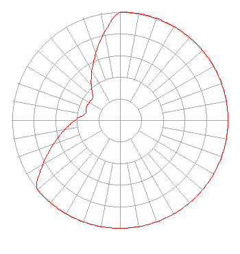 | ||||||||||||||||||
| Azimuth | Ratio | Azimuth | Ratio | Azimuth | Ratio | Azimuth | Ratio | ||||||||||||
| 0 | 1.000 | 10 | 1.000 | 20 | 1.000 | 30 | 1.000 | ||||||||||||
| 40 | 1.000 | 50 | 1.000 | 60 | 1.000 | 70 | 1.000 | ||||||||||||
| 80 | 1.000 | 90 | 1.000 | 100 | 1.000 | 110 | 1.000 | ||||||||||||
| 120 | 1.000 | 130 | 1.000 | 140 | 1.000 | 150 | 1.000 | ||||||||||||
| 160 | 1.000 | 170 | 1.000 | 180 | 1.000 | 190 | 1.000 | ||||||||||||
| 200 | 1.000 | 210 | 1.000 | 220 | 1.000 | 230 | 1.000 | ||||||||||||
| 240 | 0.826 | 250 | 0.656 | 260 | 0.521 | 270 | 0.414 | ||||||||||||
| 280 | 0.329 | 290 | 0.332 | 300 | 0.329 | 310 | 0.329 | ||||||||||||
| 320 | 0.414 | 330 | 0.521 | 340 | 0.656 | 350 | 0.826 | ||||||||||||
Structure Registration Number 1013603 Structure Type: GTOWER Registered To: American Towers LLC Structure Address: Auburn St Leicester, MA County Name: Worcester County ASR Issued: 01/05/2021 Date Built: 01/01/1982 Site Elevation: 258.5 m (848 ft.) Structure Height: 103.9 m (341 ft.) Height Overall: 104.8 m (344 ft.) Overall Height AMSL: 363.3 m (1192 ft.) FAA Determination: 06/27/2014 FAA Study #: 2014-ANE-212-OE FAA Circular #: 70/7460-1K Paint & Light FAA Chapters: 4, 8, 12 PRIOR STUDY 1996-ANE-555-OE 42-13-28.0 N 71-52-49.0 W (NAD 83) 42-13-27.7 N 71-52-50.7 W (Converted to NAD 27) |
780 Johnson Ferry Road Suite 500 Atlanta, GA 30342 Phone: 404-949-0700 Limited Liability Company | Date: 02/09/1999 Application Certifier WBA, INC. Southbridge Radio Corporation 295 Bridle Trail Road Needham, MA 02192 Applicant | |||||||||||||||||
| |||||||||||||||||||