
FCCInfo.com
A Service of Cavell, Mertz & Associates, Inc.
(855) FCC-INFO
|
|
WFNK from 12/06/1989 |
|  |
|
||||||||||||||||||||||||
|
|
WFNK Channel: 298C1 107.5 MHz Lewiston, Maine Service: FS - A full service FM station auxiliary transmitting antenna or application. Facility ID: 65675 Fac. Service: FM Status: License Application Accepted: 11/25/2008 Application Granted: 12/03/2008 File Number: BXLH-20081125ATZ License Expires: 00/00/0000 Prefix Type: This is BXLH Application Type: License To Cover FCC Website Links: LMS Facility Details This Application CDBS Application Other WFNK Applications Other WFNK Applications in CDBS Including Superseded Applications Mailing Address Correspondence for WFNK Correspondence related to application BXLH-20081125ATZ Service Contour - Open Street Map or USGS Map (60 dBu) Service Contour - KML / Google Earth (60 dBu) Public Inspection Files History Cards for WFNK Facility Type: FM STATION Class: C1, A Zone II station; with 50kW-100kW ERP and a class contour distance 52km-72km Site Location: 43-50-44.3 N 70-45-41.2 W (NAD 83) Site Location: 43-50-44.0 N 70-45-43.0 W (Converted to NAD 27) Effective Radiated Power: 15.5 kW Transmitter Output Power: 11.6 kW Antenna Center HAAT: 576.2 m (1890 ft.) Antenna Center AMSL: 730.8 m (2398 ft.) Antenna Center HAG: 461.8 m (1515 ft.) Calculated Site Elevation: 269 m. (883 ft.) Height Overall*: 508 m (1667 ft.) (* As Filed In This Application, may differ from ASR Data, Below.) Directional Antenna Antenna Make/Model: Shivley 6810-2R-DA Antenna ID: 74328 Polarization: | |||||||||||||||||||||||||||
| Antenna Data for Antenna Id: 74328 WFNK FS File: BXLH-20081125ATZ Shivley - 6810-2R-DA Service: FS | 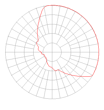 | |||||||||||||||||||||||||||
| Azimuth | Ratio | Azimuth | Ratio | Azimuth | Ratio | Azimuth | Ratio | |||||||||||||||||||||
| 0 | 1.000 | 10 | 1.000 | 20 | 1.000 | 30 | 1.000 | |||||||||||||||||||||
| 40 | 1.000 | 50 | 1.000 | 60 | 1.000 | 70 | 1.000 | |||||||||||||||||||||
| 80 | 1.000 | 90 | 1.000 | 100 | 1.000 | 110 | 1.000 | |||||||||||||||||||||
| 120 | 1.000 | 130 | 0.809 | 140 | 0.643 | 150 | 0.511 | |||||||||||||||||||||
| 160 | 0.406 | 170 | 0.405 | 180 | 0.332 | 190 | 0.313 | |||||||||||||||||||||
| 200 | 0.270 | 210 | 0.230 | 220 | 0.190 | 230 | 0.178 | |||||||||||||||||||||
| 240 | 0.178 | 250 | 0.178 | 260 | 0.220 | 270 | 0.237 | |||||||||||||||||||||
| 280 | 0.298 | 290 | 0.310 | 300 | 0.381 | 310 | 0.385 | |||||||||||||||||||||
| 320 | 0.484 | 330 | 0.609 | 340 | 0.766 | 350 | 0.964 | |||||||||||||||||||||
Structure Registration Number 1045602 Structure Type: TOWER Registered To: Hearst Properties Inc. Structure Address: Western Peak Of Bald Mountain Baldwin, ME County Name: Cumberland County ASR Issued: 08/27/2015 Date Built: 02/01/2003 Site Elevation: 269 m (883 ft.) Structure Height: 474 m (1555 ft.) Height Overall: 508 m (1667 ft.) Overall Height AMSL: 777 m (2549 ft.) FAA Determination: 03/30/1998 FAA Study #: 98-ANE-0062-OE FAA Circular #: 70/7460-1J Paint & Light FAA Chapters: 3, 4, 9, 13 SUPPLEMENTAL NOTICE STATES STRUCTURE REACHED GREATEST HEIGHT ON 09/12/2001 43-50-44.0 N 70-45-41.0 W (NAD 83) 43-50-43.7 N 70-45-42.8 W (Converted to NAD 27) |
126 Daniel Street Suite 200 Portsmouth, NH 03801 Phone: 603-431-0000 Corporation | Date: 11/25/2008 Application Certifier NASSAU BROADCASTING III, L.L.C. 619 Alexander Road Third Floor Princeton, NJ 08540-6003 Applicant DANIEL G. RYSON Cavell, Mertz & Associates, Inc. 7839 Ashton Avenue Manassas, VA 20109-2883 CONSULTANT STEPHEN DIAZ GAVIN Patton Boggs Llp | ||||||||||||||||||||||||||
|
| |||||||||||||||||||||||||||