
FCCInfo.com
A Service of Cavell, Mertz & Associates, Inc.
(855) FCC-INFO
|
|
|
|  |
|
|||||||||||||||
|
|
WSUL Channel: 252A 98.3 MHz Monticello, New York Service: FM - A full-service FM station or application. Facility ID: 56075 Fac. Service: FM Status: License 73.215 Station Application Accepted: 03/27/2000 Application Granted: 05/10/2000 File Number: BLH-20000314ABK License Expires: 00/00/0000 Prefix Type: This is a license for a commercial FM station Application Type: License To Cover FCC Website Links: LMS Facility Details This Application CDBS Application Other WSUL Applications Other WSUL Applications in CDBS Including Superseded Applications Mailing Address Correspondence for WSUL Correspondence related to application BLH-20000314ABK Service Contour - Open Street Map or USGS Map (60 dBu) Service Contour - KML / Google Earth (60 dBu) Public Inspection Files History Cards for WSUL Facility Type: FM STATION Class: A, A Zone I; I-A; or II station; with 0.1kW-6kW ERP and a class contour distance <=28km Site Location: 41-39-38.3 N 74-41-12.6 W (NAD 83) Site Location: 41-39-38.0 N 74-41-14.0 W (Converted to NAD 27) Effective Radiated Power: 2.2 kW Transmitter Output Power: 2.36 kW Antenna Center HAAT: 163 m (535 ft.) Antenna Center AMSL: 579 m (1900 ft.) Antenna Center HAG: 88 m (289 ft.) Calculated Site Elevation: 491 m. (1611 ft.) Height Overall*: 92 m (302 ft.) (* As Filed In This Application, may differ from ASR Data, Below.) Directional Antenna Antenna Make/Model: Shivley 6810-2R-SS-DA Antenna ID: 15078 Polarization: | ||||||||||||||||||
| Antenna Data for Antenna Id: 15078 WSUL FM File: BLH-20000314ABK Shivley - 6810-2R-SS-DA Service: FM | 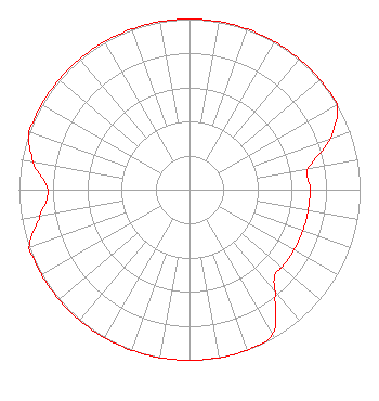 | ||||||||||||||||||
| Azimuth | Ratio | Azimuth | Ratio | Azimuth | Ratio | Azimuth | Ratio | ||||||||||||
| 0 | 1.000 | 10 | 1.000 | 20 | 1.000 | 30 | 1.000 | ||||||||||||
| 40 | 1.000 | 50 | 1.000 | 60 | 1.000 | 70 | 0.880 | ||||||||||||
| 80 | 0.707 | 90 | 0.707 | 100 | 0.707 | 110 | 0.707 | ||||||||||||
| 120 | 0.707 | 130 | 0.707 | 135 | 0.707 | 140 | 0.783 | ||||||||||||
| 150 | 0.975 | 160 | 1.000 | 170 | 1.000 | 180 | 1.000 | ||||||||||||
| 190 | 1.000 | 200 | 1.000 | 210 | 1.000 | 220 | 1.000 | ||||||||||||
| 230 | 1.000 | 240 | 1.000 | 250 | 1.000 | 260 | 0.890 | ||||||||||||
| 270 | 0.830 | 280 | 0.931 | 290 | 1.000 | 300 | 1.000 | ||||||||||||
| 310 | 1.000 | 320 | 1.000 | 330 | 1.000 | 340 | 1.000 | ||||||||||||
| 350 | 1.000 | ||||||||||||||||||
Structure Registration Number 1004409 [ASR Heights Differ from WSUL Application] Structure Type: GTOWER Registered To: SBA Towers II LLC Structure Address: 18 Hillcrest Ave (ny12188-a) Monticello, NY County Name: Sullivan County ASR Issued: 02/03/2023 Date Built: 02/20/2006 Site Elevation: 489.8 m (1607 ft.) Structure Height: 85.3 m (280 ft.) Height Overall: 92.7 m (304 ft.) Overall Height AMSL: 582.5 m (1911 ft.) FAA Determination: 10/11/2022 FAA Study #: 2021-AEA-17320-OE FAA Circular #: 70/7460-1K Paint & Light FAA Chapters: 4, 8, 12 PRIOR STUDY 2009-AEA-3844-OE 41-39-37.6 N 74-41-13.4 W (NAD 83) 41-39-37.3 N 74-41-14.8 W (Converted to NAD 27) |
575 Grove Street Honesdale, PA 18431 Phone: 570-253-1616 | Date: 03/14/2000 Application Certifier REYNOLDS COMMUNICATIONS, INC. P.o. Box 983 Monticello, NY 12701 Applicant CONSULTING RADIO ENGINEER | |||||||||||||||||
| |||||||||||||||||||