
FCCInfo.com
A Service of Cavell, Mertz & Associates, Inc.
(855) FCC-INFO
|
|
|
|
|
||||||||||||||||
|
|
K230AL Channel: 230D 93.9 MHz Boerne, Texas Service: FX - A translator or application for a translator. Facility ID: 140657 Fac. Service: FX Programming Delivery Method: Unspecified Status: License Application Accepted: 06/22/2017 Application Granted: 07/03/2017 File Number: BLFT-20170622ACI License Expires: 00/00/0000 Prefix Type: This is a license for a translator Application Type: License To Cover FCC Website Links: LMS Facility Details This Application CDBS Application Other K230AL Applications Other K230AL Applications in CDBS Including Superseded Applications Mailing Address Correspondence for K230AL Correspondence related to application BLFT-20170622ACI Service Contour - Open Street Map or USGS Map (60 dBu) Service Contour - KML / Google Earth (60 dBu) Class: D, A Noncommercial educational operating with no more than 10W Site Location: 29-48-19.8 N 98-43-12.1 W (NAD 83) Site Location: 29-48-19.0 N 98-43-11.0 W (Converted to NAD 27) Effective Radiated Power: 0.25 kW Transmitter Output Power: 0.14 kW Antenna Center HAAT: 0 m Antenna Center AMSL: 525 m (1722 ft.) Antenna Center HAG: 88 m (289 ft.) Site Elevation: 437 m. (1434 ft.) Height Overall*: 95 m (312 ft.) (* As Filed In This Application, may differ from ASR Data, Below.) Directional Antenna Antenna Make/Model: None Antenna ID: 126514 Polarization:
| ||||||||||||||||||
| Antenna Data for Antenna Id: 126514 K230AL FX File: BLFT-20170622ACI None - Service: FX | 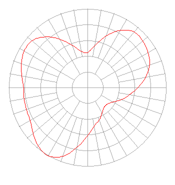 | ||||||||||||||||||
| Azimuth | Ratio | Azimuth | Ratio | Azimuth | Ratio | Azimuth | Ratio | ||||||||||||
| 0 | 0.444 | 10 | 0.541 | 20 | 0.697 | 30 | 0.839 | ||||||||||||
| 40 | 0.921 | 50 | 0.916 | 60 | 0.887 | 70 | 0.839 | ||||||||||||
| 80 | 0.750 | 90 | 0.641 | 100 | 0.540 | 110 | 0.457 | ||||||||||||
| 120 | 0.370 | 130 | 0.328 | 140 | 0.329 | 150 | 0.370 | ||||||||||||
| 160 | 0.439 | 170 | 0.498 | 180 | 0.612 | 190 | 0.772 | ||||||||||||
| 200 | 0.932 | 210 | 1.000 | 220 | 0.972 | 230 | 0.902 | ||||||||||||
| 240 | 0.841 | 250 | 0.826 | 260 | 0.818 | 270 | 0.812 | ||||||||||||
| 280 | 0.848 | 290 | 0.892 | 300 | 0.927 | 310 | 0.921 | ||||||||||||
| 320 | 0.839 | 330 | 0.710 | 340 | 0.572 | 350 | 0.467 | ||||||||||||
Structure Registration Number 1057283 [ASR Heights Differ from K230AL Application] Structure Type: GTOWER Registered To: Crown Communications LLC Structure Address: 926 Adler St Boerne, TX County Name: Kendall County ASR Issued: 12/09/2020 Date Built: 09/24/1998 Site Elevation: 436.5 m (1432 ft.) Structure Height: 91.7 m (301 ft.) Height Overall: 95.4 m (313 ft.) Overall Height AMSL: 531.9 m (1745 ft.) FAA Determination: 12/07/2020 FAA Study #: 2020-ASW-15973-OE FAA Circular #: 70/7460-1K Paint & Light FAA Chapters: 4, 8, 12 PRIOR STUDY 2016-ASW-10676-OE 29-48-23.2 N 98-43-11.6 W (NAD 83) 29-48-22.4 N 98-43-10.5 W (Converted to NAD 27) |
3505 Fredericksburg Road Kerrville, TX 78028 Phone: 830-777-9933 Limited Liability Company | Date: 06/22/2017 Application Certifier RADIO RANCH, LLC 3505 Fredericksburg Hwy 16, North Kerrville, TX 78028 Applicant BRET D. HUGGINS 24018 Middle Fork San Antonio, TX 78258 TECHNICAL CONSULTANT RADIO RANCH, LLC Radio Ranch, Llc 3505 Fredericksburg Hwy 16, North Kerrville, TX 78028 | |||||||||||||||||