
FCCInfo.com
A Service of Cavell, Mertz & Associates, Inc.
(855) FCC-INFO
|
|
K298CN from 11/26/2013 |
|
|
||||||||||||||||
|
|
K298CN Channel: 298D 107.5 MHz Boise, Idaho Service: FX - A translator or application for a translator. Facility ID: 142206 Fac. Service: FX Programming Delivery Method: Unspecified Status: License Application Accepted: 05/11/2017 Application Granted: 05/22/2017 File Number: BLFT-20170511ABQ License Expires: 00/00/0000 Prefix Type: This is a license for a translator Application Type: License To Cover FCC Website Links: LMS Facility Details This Application CDBS Application Other K298CN Applications Other K298CN Applications in CDBS Including Superseded Applications Mailing Address Correspondence for K298CN Correspondence related to application BLFT-20170511ABQ Service Contour - Open Street Map or USGS Map (60 dBu) Service Contour - KML / Google Earth (60 dBu) Class: D, A Noncommercial educational operating with no more than 10W Site Location: 43-45-17.6 N 116-05-55.4 W (NAD 83) Site Location: 43-45-18.0 N 116-05-52.0 W (Converted to NAD 27) Effective Radiated Power: 0.099 kW Transmitter Output Power: 0.139 kW Antenna Center HAAT: 0 m Antenna Center AMSL: 2163 m (7096 ft.) Antenna Center HAG: 17 m (56 ft.) Site Elevation: 2146 m. (7041 ft.) Height Overall*: 79 m (259 ft.) (* As Filed In This Application, may differ from ASR Data, Below.) Directional Antenna Antenna Make/Model: None Antenna ID: 127415 Polarization:
| ||||||||||||||||||
| Antenna Data for Antenna Id: 127415 K298CN FX File: BLFT-20170511ABQ None - Service: FX | 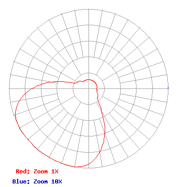 | ||||||||||||||||||
| Azimuth | Ratio | Azimuth | Ratio | Azimuth | Ratio | Azimuth | Ratio | ||||||||||||
| 0 | 0.110 | 10 | 0.110 | 20 | 0.110 | 30 | 0.110 | ||||||||||||
| 40 | 0.110 | 50 | 0.110 | 60 | 0.110 | 70 | 0.110 | ||||||||||||
| 80 | 0.110 | 90 | 0.100 | 100 | 0.110 | 110 | 0.110 | ||||||||||||
| 120 | 0.134 | 130 | 0.156 | 140 | 0.182 | 150 | 0.330 | ||||||||||||
| 160 | 0.600 | 170 | 0.810 | 180 | 0.950 | 190 | 1.000 | ||||||||||||
| 200 | 1.000 | 210 | 0.995 | 220 | 1.000 | 230 | 0.993 | ||||||||||||
| 240 | 1.000 | 250 | 0.975 | 260 | 0.880 | 270 | 0.705 | ||||||||||||
| 280 | 0.465 | 290 | 0.202 | 300 | 0.163 | 310 | 0.141 | ||||||||||||
| 320 | 0.110 | 330 | 0.110 | 340 | 0.110 | 350 | 0.110 | ||||||||||||
Structure Registration Number 1053967 Structure Type: TOWER Registered To: SUTRO CORPORATION Structure Address: Deer Point 10.75 Mi Nne Boise, ID County Name: Boise County ASR Issued: 08/03/1998 Date Built: 09/01/1975 Site Elevation: 2145.8 m (7040 ft.) Structure Height: 67 m (220 ft.) Height Overall: 79.2 m (260 ft.) Overall Height AMSL: 2225 m (7300 ft.) FAA Determination: 05/30/1997 FAA Study #: 97-ANM-0651-OE FAA Circular #: 70/7460-1J Paint & Light FAA Chapters: 3, 4, 5, 13 Removed expiration date from determination. Scenario 1./jjs/case#635066 43-45-18.0 N 116-05-55.0 W (NAD 83) 43-45-18.4 N 116-05-51.6 W (Converted to NAD 27) |
1 Manhattanville Road Suite 202 Purchase, NY 10577 Phone: 203-861-0900 Limited Liability Company | Date: 05/11/2017 Application Certifier TOWNSQUARE MEDIA BOISE LICENSE, LLC 240 Greenwich Avenue Greenwich, CT 06830 Applicant MARTIN STABBERT 240 Greenwich Ave. Greenwich, CT 06830 VP/ENGINEERING HOWARD M. LIBERMAN Wilkinson Barker Knauer, Llp 1800 M Street, N.w. Suite 800n Washington, DC 20036 | |||||||||||||||||