
FCCInfo.com
A Service of Cavell, Mertz & Associates, Inc.
(855) FCC-INFO
|
|
|
|  |
|
|||||||||||||||
|
|
WMHQ Channel: 211A 90.1 MHz Malone, New York Service: FM - A full-service FM station or application. Facility ID: 89863 Fac. Service: FM Status: License Application Accepted: 12/01/2003 Application Granted: 12/24/2003 File Number: BLED-20031201APH License Expires: 00/00/0000 Prefix Type: This is a license for a noncommercial educational FM station Application Type: License To Cover FCC Website Links: LMS Facility Details This Application CDBS Application Other WMHQ Applications Other WMHQ Applications in CDBS Including Superseded Applications Mailing Address Correspondence for WMHQ Correspondence related to application BLED-20031201APH Service Contour - Open Street Map or USGS Map (60 dBu) Service Contour - KML / Google Earth (60 dBu) Public Inspection Files Facility Type: NON-COMMERCIAL EDUC. FM Class: A, A Zone I; I-A; or II station; with 0.1kW-6kW ERP and a class contour distance <=28km Site Location: 44-49-41.2 N 74-22-41.6 W (NAD 83) Site Location: 44-49-41.0 N 74-22-43.0 W (Converted to NAD 27) Effective Radiated Power: 2.7 kW Transmitter Output Power: 0.849 kW Antenna Center HAAT: 108 m (354 ft.) Antenna Center AMSL: 356.1 m (1168 ft.) Antenna Center HAG: 30 m (98 ft.) Site Elevation: 326.1 m. (1070 ft.) Height Overall*: 36.6 m (120 ft.) (* As Filed In This Application, may differ from ASR Data, Below.) Directional Antenna Antenna Make/Model: Shivley 6810-4R-DA, four sections Antenna ID: 58990 Polarization:
| ||||||||||||||||||
| Antenna Data for Antenna Id: 58990 WMHQ FM File: BLED-20031201APH Shivley - 6810-4R-DA, four sections Service: FM | 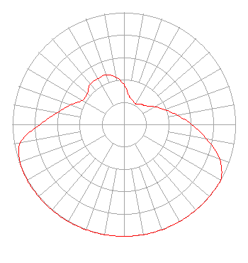 | ||||||||||||||||||
| Azimuth | Ratio | Azimuth | Ratio | Azimuth | Ratio | Azimuth | Ratio | ||||||||||||
| 0 | 0.354 | 10 | 0.258 | 20 | 0.228 | 30 | 0.211 | ||||||||||||
| 40 | 0.236 | 50 | 0.258 | 60 | 0.316 | 70 | 0.387 | ||||||||||||
| 80 | 0.483 | 90 | 0.606 | 100 | 0.753 | 110 | 0.913 | ||||||||||||
| 120 | 1.000 | 130 | 1.000 | 140 | 1.000 | 150 | 1.000 | ||||||||||||
| 160 | 1.000 | 170 | 1.000 | 180 | 1.000 | 190 | 1.000 | ||||||||||||
| 200 | 1.000 | 210 | 1.000 | 220 | 1.000 | 230 | 1.000 | ||||||||||||
| 240 | 1.000 | 250 | 0.991 | 260 | 0.943 | 270 | 0.753 | ||||||||||||
| 280 | 0.606 | 290 | 0.509 | 300 | 0.430 | 310 | 0.430 | ||||||||||||
| 320 | 0.471 | 330 | 0.471 | 340 | 0.471 | 350 | 0.430 | ||||||||||||
Structure Registration Number 1238331 Structure Type: TOWER Registered To: Mars Hill Broadcasting Co Inc Structure Address: Perry Hill Bangor, NY County Name: Franklin County ASR Issued: 10/11/2010 Date Built: 10/17/2003 Site Elevation: 326.1 m (1070 ft.) Structure Height: 36.6 m (120 ft.) Height Overall: 36.6 m (120 ft.) Overall Height AMSL: 362.7 m (1190 ft.) FAA Determination: 06/24/2003 FAA Study #: 2003-AEA-2002-OE FAA Circular #: Paint & Light FAA Chapters: NONE PRIOR STUDY 2002-AEA-3597-OE 44-49-41.2 N 74-22-41.6 W (NAD 83) 44-49-41.0 N 74-22-43.0 W (Converted to NAD 27) |
4044 Makyes Rd Syracuse, NY 13215 Phone: 315-469-5051 Not-for-Profit | Date: 12/01/2003 Application Certifier MARS HILL BROADCASTING CO. INC. 4044 Makyes Rd Syracuse, Ny, NY 13215 Applicant RONALD J ZORN JR Mars Hill Broadcasting Co Inc 4044 Makyes Rd Syracuse, Ny, NY 13215 CHIEF ENGINEER RONALD J ZORN JR Mars Hill Broadcasting Co Inc | |||||||||||||||||