
FCCInfo.com
A Service of Cavell, Mertz & Associates, Inc.
(855) FCC-INFO
|
|
WJKI-FM from 12/17/2004 WJKI-FM from 08/16/2000 WJKI-FM from 11/21/1997 WJKI-FM from 09/08/1995 WJKI-FM from 07/07/1995 WJKI-FM from 03/12/1993 |
|
|
||||||||||||||||
|
|
WJKI-FM Channel: 278A 103.5 MHz Bethany Beach, Delaware Service: FS - A full service FM station auxiliary transmitting antenna or application. Facility ID: 30858 Fac. Service: FM Status: License Application Accepted: 02/28/2019 Application Granted: 03/18/2019 File Number: BXLH-20190228AAD License Expires: 00/00/0000 Prefix Type: This is BXLH Application Type: License To Cover FCC Website Links: LMS Facility Details This Application CDBS Application Other WJKI-FM Applications Other WJKI-FM Applications in CDBS Including Superseded Applications Mailing Address Correspondence for WJKI-FM Correspondence related to application BXLH-20190228AAD Service Contour - Open Street Map or USGS Map (60 dBu) Service Contour - KML / Google Earth (60 dBu) Public Inspection Files Facility Type: FM STATION Class: A, A Zone I; I-A; or II station; with 0.1kW-6kW ERP and a class contour distance <=28km Site Location: 38-37-34.4 N 75-14-00.7 W (NAD 83) Site Location: 38-37-34.0 N 75-14-02.0 W (Converted to NAD 27) Effective Radiated Power: 3.2 kW Transmitter Output Power: 1.53 kW Antenna Center HAAT: 135.9 m (446 ft.) Antenna Center AMSL: 142.6 m (468 ft.) Antenna Center HAG: 135.6 m (445 ft.) Calculated Site Elevation: 7 m. (23 ft.) Height Overall*: 140 m (459 ft.) (* As Filed In This Application, may differ from ASR Data, Below.) Directional Antenna Antenna Make/Model: Propagation System Inc PSIFM-2C-DA Antenna ID: 132005 Polarization: | ||||||||||||||||||
| Antenna Data for Antenna Id: 132005 WJKI-FM FS File: BXLH-20190228AAD Propagation System Inc - PSIFM-2C-DA Service: FS Pattern and Field Values Include a 25° Clockwise Rotation | 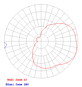 | ||||||||||||||||||
| Azimuth | Ratio | Azimuth | Ratio | Azimuth | Ratio | Azimuth | Ratio | ||||||||||||
| 5 | 0.262 | 15 | 0.349 | 25 | 0.474 | 35 | 0.552 | ||||||||||||
| 45 | 0.674 | 55 | 0.803 | 65 | 0.890 | 75 | 0.932 | ||||||||||||
| 85 | 0.945 | 95 | 0.966 | 105 | 1.000 | 115 | 0.992 | ||||||||||||
| 125 | 0.948 | 135 | 0.869 | 145 | 0.784 | 155 | 0.769 | ||||||||||||
| 165 | 0.756 | 175 | 0.731 | 185 | 0.688 | 195 | 0.646 | ||||||||||||
| 205 | 0.525 | 215 | 0.392 | 225 | 0.304 | 235 | 0.215 | ||||||||||||
| 245 | 0.165 | 255 | 0.116 | 265 | 0.094 | 275 | 0.128 | ||||||||||||
| 285 | 0.137 | 295 | 0.137 | 305 | 0.134 | 315 | 0.131 | ||||||||||||
| 325 | 0.120 | 335 | 0.120 | 345 | 0.114 | 355 | 0.156 | ||||||||||||
Structure Registration Number 1065742 Structure Type: TOWER Registered To: SUSSEX, COUNTY OF DBA = EMERGENCY OPERATIONS CENTER Structure Address: Sx 297 3km W Of De 24 Indian River Hundred, DE County Name: Sussex County ASR Issued: 06/25/1999 Date Built: 01/01/1991 Site Elevation: 7 m (23 ft.) Structure Height: 137 m (449 ft.) Height Overall: 140 m (459 ft.) Overall Height AMSL: 147 m (482 ft.) FAA Determination: 07/07/1989 FAA Study #: 89-AEA-0830-OE FAA Circular #: 70/7460-1G Paint & Light FAA Chapters: 3, 4, 5, 9 38-37-34.0 N 75-14-01.0 W (NAD 83) 38-37-33.6 N 75-14-02.3 W (Converted to NAD 27) |
20254 Dupont Blvd Georgetown, DE 19947 Phone: 302-858-5118 Limited Liability Company | Date: 02/28/2019 Application Certifier THE VOICE RADIO, LLC 17818 Cape Drive Lewes, DE 19958 Applicant S. K. KHANNA Smith Khanna & Guill, Inc. 1203 Woodlea Mill Ct Mc Lean, VA 22102-2313 CONSULTING ENGINEER JERROLD MILLER Miller And Neely, Pc | |||||||||||||||||
| |||||||||||||||||||