
FCCInfo.com
A Service of Cavell, Mertz & Associates, Inc.
(855) FCC-INFO
|
|
K278AN from 04/21/1987 K278AN from 08/08/1985 |
|
|
||||||||||||||||
|
|
K278AN Channel: 278D 103.5 MHz Rapid City, South Dakota Service: FX - A translator or application for a translator. Facility ID: 17677 Fac. Service: FX Programming Delivery Method: Unspecified Status: License Application Accepted: 01/07/2000 Application Granted: 06/19/2000 File Number: BLFT-19991105AAU License Expires: 00/00/0000 Prefix Type: This is a license for a translator Application Type: License To Cover FCC Website Links: LMS Facility Details This Application CDBS Application Other K278AN Applications Other K278AN Applications in CDBS Including Superseded Applications Mailing Address Correspondence for K278AN Correspondence related to application BLFT-19991105AAU Service Contour - Open Street Map or USGS Map (60 dBu) Service Contour - KML / Google Earth (60 dBu) Class: D, A Noncommercial educational operating with no more than 10W Site Location: 44-04-08.0 N 103-15-04.7 W (NAD 83) Site Location: 44-04-08.0 N 103-15-03.0 W (Converted to NAD 27) Effective Radiated Power: 0.28 kW Horiz. ; 0 kW Vert. Transmitter Output Power: 0.04 kW Antenna Center HAAT: 113.5 m Horiz.; 0 m Vert. Antenna Center AMSL: 1214 m Horiz.; 0 m Vert. Antenna Center HAG: 68 m Horiz.; 0 m Vert. Calculated Site Elevation: 1146 m. (3760 ft.) Height Overall*: 185 m (607 ft.) (* As Filed In This Application, may differ from ASR Data, Below.) Directional Antenna Antenna Make/Model: None Antenna ID: 16185 Polarization:
| ||||||||||||||||||
| Antenna Data for Antenna Id: 16185 K278AN FX File: BLFT-19991105AAU None - Service: FX Pattern and Field Values Include a 45° Clockwise Rotation | 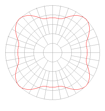 | ||||||||||||||||||
| Azimuth | Ratio | Azimuth | Ratio | Azimuth | Ratio | Azimuth | Ratio | ||||||||||||
| 5 | 0.734 | 15 | 0.739 | 25 | 0.840 | 35 | 0.953 | ||||||||||||
| 45 | 1.000 | 55 | 0.953 | 65 | 0.840 | 75 | 0.739 | ||||||||||||
| 85 | 0.734 | 95 | 0.734 | 105 | 0.739 | 115 | 0.840 | ||||||||||||
| 125 | 0.953 | 135 | 1.000 | 145 | 0.953 | 155 | 0.840 | ||||||||||||
| 165 | 0.739 | 175 | 0.734 | 185 | 0.734 | 195 | 0.739 | ||||||||||||
| 205 | 0.840 | 215 | 0.953 | 225 | 1.000 | 235 | 0.953 | ||||||||||||
| 245 | 0.840 | 255 | 0.739 | 265 | 0.734 | 275 | 0.734 | ||||||||||||
| 285 | 0.739 | 295 | 0.840 | 305 | 0.953 | 315 | 1.000 | ||||||||||||
| 325 | 0.953 | 335 | 0.840 | 345 | 0.739 | 355 | 0.734 | ||||||||||||
Structure Registration Number 1042359 Structure Type: TOWER Registered To: DUHAMEL BROADCASTING ENTERPRISES Structure Address: 1629 Skyline Dr Rapid City, SD County Name: Pennington County ASR Issued: 03/24/2010 Date Built: 05/01/1964 Site Elevation: 1146 m (3760 ft.) Structure Height: 152.4 m (500 ft.) Height Overall: 185 m (607 ft.) Overall Height AMSL: 1331 m (4367 ft.) FAA Determination: 06/16/1964 FAA Study #: CE-OE-5697 Paint & Light FAA Chapters: 1, 3, 5, 14, 21 RED LIGHTS/PAINT 44-04-08.0 N 103-15-05.0 W (NAD 83) 44-04-08.0 N 103-15-03.3 W (Converted to NAD 27) |
407 West 11th Street Yankton, SD 57078 Phone: 605-661-2393 Limited Liability Company | Date: 11/05/1999 Application Certifier DUHAMEL BROADCASTING ENTERPRISES 2001 Pennsylvania Avenue, N.w., Suite 40 Washington,, DC 20006 Applicant WILLIAM DUHAMEL | |||||||||||||||||