
FCCInfo.com
A Service of Cavell, Mertz & Associates, Inc.
(855) FCC-INFO
|
|
|
|  |
|
|||||||||||||||
|
|
WFBE Channel: 236B 95.1 MHz Flint, Michigan Service: FM - A full-service FM station or application. Facility ID: 21730 Fac. Service: FM Status: License Application Accepted: 04/01/2010 Application Granted: 04/27/2010 File Number: BLH-20100401ADX License Expires: 00/00/0000 Prefix Type: This is a license for a commercial FM station Application Type: License To Cover FCC Website Links: LMS Facility Details This Application CDBS Application Other WFBE Applications Other WFBE Applications in CDBS Including Superseded Applications Mailing Address Correspondence for WFBE Correspondence related to application BLH-20100401ADX Service Contour - Open Street Map or USGS Map (54 dBu) Service Contour - KML / Google Earth (54 dBu) Public Inspection Files History Cards for WFBE Facility Type: FM STATION Class: B, A Zone I or I-A station; with 25kW-50kW ERP and a class contour distance 39km-52km Site Location: 42-58-26.1 N 83-39-00.8 W (NAD 83) Site Location: 42-58-26.0 N 83-39-01.0 W (Converted to NAD 27) Effective Radiated Power: 34 kW Transmitter Output Power: 11.9 kW Antenna Center HAAT: 97 m (318 ft.) Antenna Center AMSL: 343 m (1125 ft.) Antenna Center HAG: 102 m (335 ft.) Calculated Site Elevation: 241 m. (791 ft.) Height Overall*: 112.7 m (370 ft.) (* As Filed In This Application, may differ from ASR Data, Below.) Directional Antenna Antenna Make/Model: Electronics Research Inc. MP-6E-DA-HW Antenna ID: 89994 Polarization: | ||||||||||||||||||
| Antenna Data for Antenna Id: 89994 WFBE FM File: BLH-20100401ADX Electronics Research Inc. - MP-6E-DA-HW Service: FM | 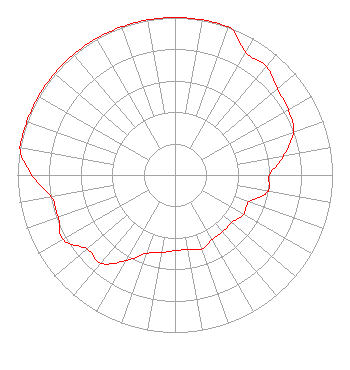 | ||||||||||||||||||
| Azimuth | Ratio | Azimuth | Ratio | Azimuth | Ratio | Azimuth | Ratio | ||||||||||||
| 0 | 1.000 | 10 | 1.000 | 20 | 1.000 | 30 | 0.900 | ||||||||||||
| 40 | 0.900 | 50 | 0.850 | 60 | 0.830 | 70 | 0.800 | ||||||||||||
| 80 | 0.700 | 90 | 0.600 | 100 | 0.600 | 110 | 0.500 | ||||||||||||
| 120 | 0.500 | 130 | 0.470 | 140 | 0.470 | 150 | 0.470 | ||||||||||||
| 160 | 0.500 | 170 | 0.480 | 180 | 0.480 | 190 | 0.500 | ||||||||||||
| 200 | 0.530 | 210 | 0.630 | 220 | 0.730 | 230 | 0.730 | ||||||||||||
| 240 | 0.820 | 250 | 0.790 | 260 | 0.800 | 270 | 0.910 | ||||||||||||
| 280 | 1.000 | 290 | 1.000 | 300 | 1.000 | 310 | 1.000 | ||||||||||||
| 320 | 1.000 | 330 | 1.000 | 340 | 1.000 | 350 | 1.000 | ||||||||||||
Structure Registration Number 1007357 Structure Type: 3LTA1 Registered To: VB Nimbus, LLC Structure Address: 3076 E Bristol (twr 1) Burton, MI County Name: Genesee County ASR Issued: 10/14/2020 Date Built: 01/01/1965 Site Elevation: 240.8 m (790 ft.) Structure Height: 111.9 m (367 ft.) Height Overall: 112.8 m (370 ft.) Overall Height AMSL: 353.6 m (1160 ft.) FAA Determination: 04/09/2020 FAA Study #: 2020-AGL-5895-OE FAA Circular #: 70/7460-1H Paint & Light FAA Chapters: 3, 4, 5, 13 PRIOR STUDY 1995-AGL-2983-OE 42-58-26.5 N 83-38-59.4 W (NAD 83) 42-58-26.4 N 83-38-59.6 W (Converted to NAD 27) |
780 Johnson Ferry Road Suite 500 Atlanta, GA 30342 Phone: 404-949-0700 Limited Liability Company | Date: 04/01/2010 Application Certifier CITADEL BROADCASTING COMPANY 7201 West Lake Mead Boulevard Suite 400 Las Vegas, NV 89128-8366 Applicant RUSSELL C. HARBAUGH, JR. 27451 Everett Street Southfield, MI 48076 CONSULTING ENGINEER CHRISTOPHER J. SOVA Citadel Broadcasting Company | |||||||||||||||||
|
| ||||||||||||||||||