
FCCInfo.com
A Service of Cavell, Mertz & Associates, Inc.
(855) FCC-INFO
|
|
W241CM from 04/10/1984 |
|
|
||||||||||||||||
|
|
W241CM Channel: 241D 96.1 MHz Cortland, New York Service: FX - A translator or application for a translator. Facility ID: 13971 Fac. Service: FX Programming Delivery Method: Unspecified Status: License Application Accepted: 01/22/2018 Application Granted: 02/06/2018 File Number: BLFT-20180122ABD License Expires: 00/00/0000 Prefix Type: This is a license for a translator Application Type: License To Cover FCC Website Links: LMS Facility Details This Application CDBS Application Other W241CM Applications Other W241CM Applications in CDBS Including Superseded Applications Mailing Address Correspondence for W241CM Correspondence related to application BLFT-20180122ABD Service Contour - Open Street Map or USGS Map (60 dBu) Service Contour - KML / Google Earth (60 dBu) Class: D, A Noncommercial educational operating with no more than 10W Site Location: 42-34-26.3 N 76-11-14.7 W (NAD 83) Site Location: 42-34-26.0 N 76-11-16.0 W (Converted to NAD 27) Effective Radiated Power: 0.05 kW Transmitter Output Power: 0.107 kW Antenna Center HAAT: 0 m Antenna Center AMSL: 480 m (1575 ft.) Antenna Center HAG: 9 m (30 ft.) Site Elevation: 471 m. (1545 ft.) Height Overall*: 11 m (36 ft.) (* As Filed In This Application, may differ from ASR Data, Below.) Directional Antenna Antenna Make/Model: None Antenna ID: 125399 Polarization:
| ||||||||||||||||||
| Antenna Data for Antenna Id: 125399 W241CM FX File: BLFT-20180122ABD None - Service: FX Pattern and Field Values Include a 40° Clockwise Rotation | 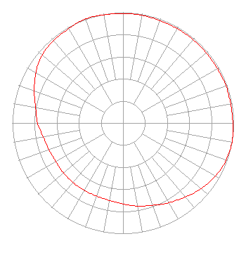 | ||||||||||||||||||
| Azimuth | Ratio | Azimuth | Ratio | Azimuth | Ratio | Azimuth | Ratio | ||||||||||||
| 0 | 0.988 | 10 | 0.988 | 20 | 0.983 | 30 | 0.983 | ||||||||||||
| 40 | 0.983 | 50 | 0.983 | 60 | 0.983 | 70 | 0.988 | ||||||||||||
| 80 | 0.988 | 90 | 0.992 | 100 | 1.000 | 110 | 0.991 | ||||||||||||
| 120 | 0.963 | 130 | 0.923 | 140 | 0.873 | 150 | 0.832 | ||||||||||||
| 160 | 0.792 | 170 | 0.762 | 180 | 0.732 | 190 | 0.710 | ||||||||||||
| 200 | 0.702 | 210 | 0.702 | 220 | 0.702 | 230 | 0.702 | ||||||||||||
| 240 | 0.702 | 250 | 0.712 | 260 | 0.732 | 270 | 0.772 | ||||||||||||
| 280 | 0.802 | 290 | 0.853 | 300 | 0.909 | 310 | 0.953 | ||||||||||||
| 320 | 0.973 | 330 | 0.983 | 340 | 1.000 | 350 | 0.992 | ||||||||||||
Structure Registration Number 1301206 Structure Type: POLE Registered To: Mars Hill Broadcasting Co. Inc. Structure Address: 0.4 Km E Of Owego St. (ny Rt 215), 1 Km S Of Starr Rd. Cortland, NY County Name: Cortland County ASR Issued: 01/05/2017 Site Elevation: 470.9 m (1545 ft.) Structure Height: 10.7 m (35 ft.) Height Overall: 10.7 m (35 ft.) Overall Height AMSL: 481.6 m (1580 ft.) FAA Determination: 08/26/2016 FAA Study #: 2016-AEA-7406-OE Paint & Light FAA Chapters: NONE 42-34-26.6 N 76-11-14.4 W (NAD 83) 42-34-26.3 N 76-11-15.7 W (Converted to NAD 27) |
4044 Makyes Road Syracuse, NY 13215 Phone: 315-469-5051 Not-for-Profit | Date: 01/22/2018 Application Certifier MARS HILL BROADCASTING CO., INC. 4044 Makyes Rd Syracuse, NY 13215 Applicant MICHAEL DWINELL 4044 Makyes Road Syracuse, NY 13215 CHIEF ENGINEER MATTHEW H. MCCORMICK Fletcher, Heald & Hildreth, Plc 1300 North 17th Street 11th Floor Arlington, VA 22209 | |||||||||||||||||