
FCCInfo.com
A Service of Cavell, Mertz & Associates, Inc.
(855) FCC-INFO
|
|
|
|
|
||||||||||||||||
|
|
WHMC-FM Channel: 211C1 90.1 MHz Conway, South Carolina Service: FM - A full-service FM station or application. Facility ID: 60998 Fac. Service: FM Status: License Application Accepted: 10/31/2013 Application Granted: 11/08/2013 File Number: BLED-20131031AFM License Expires: 00/00/0000 Prefix Type: This is a license for a noncommercial educational FM station Application Type: License To Cover FCC Website Links: LMS Facility Details This Application CDBS Application Other WHMC-FM Applications Other WHMC-FM Applications in CDBS Including Superseded Applications Mailing Address Correspondence for WHMC-FM Correspondence related to application BLED-20131031AFM Service Contour - Open Street Map or USGS Map (60 dBu) Service Contour - KML / Google Earth (60 dBu) Public Inspection Files Facility Type: NON-COMMERCIAL EDUC. FM Class: C1, A Zone II station; with 50kW-100kW ERP and a class contour distance 52km-72km Site Location: 33-56-58.6 N 79-06-30.1 W (NAD 83) Site Location: 33-56-58.0 N 79-06-31.0 W (Converted to NAD 27) Effective Radiated Power: 63 kW Transmitter Output Power: 11.1 kW Antenna Center HAAT: 213.4 m (700 ft.) Antenna Center AMSL: 233.3 m (765 ft.) Antenna Center HAG: 209 m (686 ft.) Calculated Site Elevation: 24.3 m. (80 ft.) Height Overall*: 249.2 m (818 ft.) (* As Filed In This Application, may differ from ASR Data, Below.) Directional Antenna Antenna Make/Model: Shivley 6810-8R-CF, eight sections Antenna ID: 96505 Polarization:
| ||||||||||||||||||
| Antenna Data for Antenna Id: 96505 WHMC-FM FM File: BLED-20131031AFM Shivley - 6810-8R-CF, eight sections Service: FM | 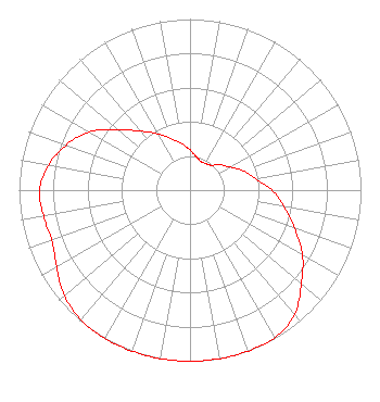 | ||||||||||||||||||
| Azimuth | Ratio | Azimuth | Ratio | Azimuth | Ratio | Azimuth | Ratio | ||||||||||||
| 0 | 0.235 | 10 | 0.200 | 20 | 0.180 | 30 | 0.180 | ||||||||||||
| 40 | 0.190 | 50 | 0.230 | 60 | 0.270 | 70 | 0.330 | ||||||||||||
| 80 | 0.390 | 90 | 0.480 | 100 | 0.560 | 110 | 0.650 | ||||||||||||
| 120 | 0.760 | 130 | 0.850 | 140 | 0.950 | 150 | 0.995 | ||||||||||||
| 160 | 1.000 | 170 | 1.000 | 180 | 1.000 | 190 | 1.000 | ||||||||||||
| 200 | 1.000 | 210 | 1.000 | 220 | 0.990 | 230 | 0.960 | ||||||||||||
| 240 | 0.900 | 250 | 0.860 | 260 | 0.870 | 270 | 0.880 | ||||||||||||
| 280 | 0.840 | 290 | 0.770 | 300 | 0.680 | 310 | 0.550 | ||||||||||||
| 320 | 0.450 | 330 | 0.380 | 340 | 0.320 | 350 | 0.275 | ||||||||||||
Structure Registration Number 1059179 Structure Type: TOWER Registered To: South Carolina Educational TV Commission Structure Address: Site Is Located 6.5 Miles Nnw Of Conway Conway, SC County Name: Horry County ASR Issued: 08/24/2018 Date Built: 08/17/2005 Site Elevation: 24.3 m (80 ft.) Structure Height: 233.4 m (766 ft.) Height Overall: 249.2 m (818 ft.) Overall Height AMSL: 273.5 m (897 ft.) FAA Determination: 07/19/2004 FAA Study #: 2004-ASO-3525-OE FAA Circular #: 70/7460-1J Paint & Light FAA Chapters: 3, 4, 5, 13 OM&L to remain the same as prior study = PAINT/RED LIGHTS 33-56-59.0 N 79-06-30.0 W (NAD 83) 33-56-58.4 N 79-06-30.9 W (Converted to NAD 27) |
1041 George Rogers Boulevard Columbia, SC 29201 Phone: 803-737-3500 Government Entity | Date: 10/31/2013 Application Certifier SOUTH CAROLINA EDUCATIONAL TELEVISION COMMISSION 1101 George Rogers Boulevard Columbia, SC 29201 Applicant WILLIAM T. GODFREY, JR. Kessler And Gehman Associates, Inc. 507-c Nw 60th Street Gainesville, FL 32607-2055 CONSULTING ENGINEERS MARGARET L. MILLER Dow Lohnes Pllc | |||||||||||||||||