
FCCInfo.com
A Service of Cavell, Mertz & Associates, Inc.
(855) FCC-INFO
|
|
|
|
|
||||||||||||||||
|
|
W217AS Channel: 217D 91.3 MHz Terre Haute, Indiana Service: FX - A translator or application for a translator. Facility ID: 86934 Fac. Service: FX Programming Delivery Method: Unspecified Status: License Application Accepted: 08/03/2004 Application Granted: 02/14/2005 File Number: BLFT-20040803AAL License Expires: 08/01/2028 Prefix Type: This is a license for a translator Application Type: License To Cover FCC Website Links: LMS Facility Details This Application CDBS Application Other W217AS Applications Other W217AS Applications in CDBS Including Superseded Applications Mailing Address Correspondence for W217AS Correspondence related to application BLFT-20040803AAL Service Contour - Open Street Map or USGS Map (60 dBu) Service Contour - KML / Google Earth (60 dBu) Class: D, A Noncommercial educational operating with no more than 10W Site Location: 39-30-14.1 N 87-26-37.1 W (NAD 83) Site Location: 39-30-14.0 N 87-26-37.0 W (Converted to NAD 27) Effective Radiated Power: 0 kW Horiz. ; 0.01 kW Vert. Transmitter Output Power: 0.004 kW Antenna Center HAAT: 0 m Horiz.; 94 m Vert. Antenna Center AMSL: 0 m Horiz.; 256 m Vert. Antenna Center HAG: 0 m Horiz.; 85 m Vert. Site Elevation: 171 m. (561 ft.) Height Overall*: 210 m (689 ft.) (* As Filed In This Application, may differ from ASR Data, Below.) Directional Antenna Antenna Make/Model: Scala CLFM(V) Antenna ID: 65587 Polarization: H
| ||||||||||||||||||
| Antenna Data for Antenna Id: 65587 W217AS FX File: BLFT-20040803AAL Scala - CLFM(V) Service: FX Pattern and Field Values Include a 120° Clockwise Rotation | 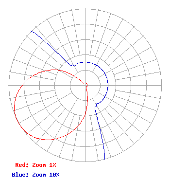 | ||||||||||||||||||
| Azimuth | Ratio | Azimuth | Ratio | Azimuth | Ratio | Azimuth | Ratio | ||||||||||||
| 0 | 0.030 | 10 | 0.030 | 20 | 0.030 | 30 | 0.030 | ||||||||||||
| 40 | 0.030 | 50 | 0.030 | 60 | 0.030 | 70 | 0.030 | ||||||||||||
| 80 | 0.030 | 90 | 0.030 | 100 | 0.030 | 110 | 0.030 | ||||||||||||
| 120 | 0.030 | 130 | 0.030 | 140 | 0.030 | 150 | 0.030 | ||||||||||||
| 160 | 0.050 | 170 | 0.190 | 180 | 0.390 | 190 | 0.544 | ||||||||||||
| 200 | 0.690 | 210 | 0.817 | 220 | 0.916 | 230 | 0.980 | ||||||||||||
| 240 | 1.000 | 250 | 0.980 | 260 | 0.916 | 270 | 0.817 | ||||||||||||
| 280 | 0.690 | 290 | 0.544 | 300 | 0.390 | 310 | 0.190 | ||||||||||||
| 320 | 0.050 | 330 | 0.030 | 340 | 0.030 | 350 | 0.030 | ||||||||||||
Structure Registration Number 1029491 Structure Type: TOWER Structure Address: 1647 W Mulberry Ave Terre Haute, IN County Name: Vigo County ASR Issued: 09/28/2004 Date Built: 05/01/1997 Site Elevation: 170.7 m (560 ft.) Structure Height: 210 m (689 ft.) Height Overall: 210 m (689 ft.) Overall Height AMSL: 380.7 m (1249 ft.) FAA Determination: 06/03/1997 FAA Study #: 97-AGL-2450-OE FAA Circular #: 70/7460-1J Paint & Light FAA Chapters: 3, 4, 5, 13 39-30-14.0 N 87-26-37.0 W (NAD 83) 39-30-13.9 N 87-26-36.9 W (Converted to NAD 27) |
4002 N. 3300 E. Twin Falls, ID 83301 Phone: 208-734-6633 Not-for-Profit | Date: 08/03/2004 Application Certifier PENSACOLA CHRISTIAN COLLEGE, INC. P.o. Box 18000 Pensacola, FL 32523-9160 Applicant DONALD A. DIPPEL 250 Brent Lane Pensacola, FL 32503 ENGINEER LEE W. SHUBERT, ESQ. Katten Muchin Zavis Rosenman 1025 Thomas Jefferson Street, N.w. East Lobby, Suite 700 Washington, DC 20007-5201 | |||||||||||||||||