
FCCInfo.com
A Service of Cavell, Mertz & Associates, Inc.
(855) FCC-INFO
|
|
|
|
|
||||||||||||||||
|
|
KQNY Channel: 220A 91.9 MHz Quincy, California Service: FM - A full-service FM station or application. Facility ID: 172610 Fac. Service: FM Status: License Application Accepted: 07/27/2010 Application Granted: 09/09/2010 File Number: BLED-20100727ACJ License Expires: 00/00/0000 Prefix Type: This is a license for a noncommercial educational FM station Application Type: License To Cover FCC Website Links: LMS Facility Details This Application CDBS Application Other KQNY Applications Other KQNY Applications in CDBS Including Superseded Applications Mailing Address Correspondence for KQNY Correspondence related to application BLED-20100727ACJ Service Contour - Open Street Map or USGS Map (60 dBu) Service Contour - KML / Google Earth (60 dBu) Public Inspection Files Facility Type: NON-COMMERCIAL EDUC. FM Class: A, A Zone I; I-A; or II station; with 0.1kW-6kW ERP and a class contour distance <=28km Site Location: 39-56-14.6 N 120-56-52.8 W (NAD 83) Site Location: 39-56-15.0 N 120-56-49.0 W (Converted to NAD 27) Effective Radiated Power: 2.7 kW Transmitter Output Power: 0.88 kW Antenna Center HAAT: -342 m Antenna Center AMSL: 1057 m (3468 ft.) Antenna Center HAG: 15 m (49 ft.) Calculated Site Elevation: 1042 m. (3419 ft.) Height Overall*: 16.2 m (53 ft.) (* As Filed In This Application, may differ from ASR Data, Below.) Directional Antenna Antenna Make/Model: Shivley 6810-3R-.925SS-DA,3 Sections.9wavelength spaced Antenna ID: 88140 Polarization: | ||||||||||||||||||
| Antenna Data for Antenna Id: 88140 KQNY FM File: BLED-20100727ACJ Shivley - 6810-3R-.925SS-DA,3 Sections.9wavelength spaced Service: FM | 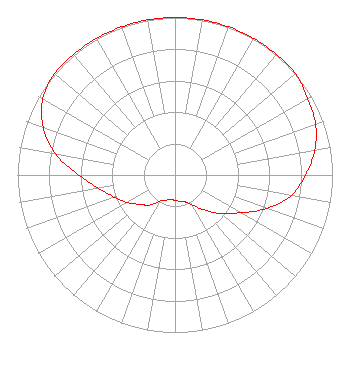 | ||||||||||||||||||
| Azimuth | Ratio | Azimuth | Ratio | Azimuth | Ratio | Azimuth | Ratio | ||||||||||||
| 0 | 1.000 | 10 | 1.000 | 20 | 1.000 | 30 | 1.000 | ||||||||||||
| 40 | 1.000 | 50 | 1.000 | 60 | 0.970 | 70 | 0.950 | ||||||||||||
| 80 | 0.900 | 90 | 0.830 | 100 | 0.750 | 110 | 0.620 | ||||||||||||
| 120 | 0.480 | 130 | 0.380 | 140 | 0.290 | 150 | 0.220 | ||||||||||||
| 160 | 0.180 | 170 | 0.170 | 180 | 0.160 | 190 | 0.160 | ||||||||||||
| 200 | 0.170 | 210 | 0.190 | 220 | 0.250 | 230 | 0.290 | ||||||||||||
| 240 | 0.350 | 250 | 0.410 | 260 | 0.490 | 270 | 0.610 | ||||||||||||
| 280 | 0.770 | 290 | 0.890 | 300 | 0.970 | 310 | 1.000 | ||||||||||||
| 320 | 1.000 | 330 | 1.000 | 340 | 1.000 | 350 | 1.000 | ||||||||||||
Structure Registration Number 1226942 Structure Type: TOWER Structure Address: 61 Bradley Street Quincy, CA County Name: Plumas County ASR Issued: 06/27/2005 Date Built: 07/01/2001 Site Elevation: 1042.3 m (3420 ft.) Structure Height: 16.2 m (53 ft.) Height Overall: 16.2 m (53 ft.) Overall Height AMSL: 1058.5 m (3473 ft.) FAA Determination: 06/14/2001 FAA Study #: 01-awp-1597-oe Paint & Light FAA Chapters: NONE Removed expiration date from determination. Scenario 1./jjs/case#635066 39-56-14.4 N 120-56-52.6 W (NAD 83) 39-56-14.8 N 120-56-48.8 W (Converted to NAD 27) |
Pob 350 Quincy, Ca, CA 95971 Phone: 530-283-0202 Not-for-Profit | Date: 07/27/2010 Application Certifier PLUMAS COMMUNITY RADIO Pob 350 Quincy, Ca, CA 95971 Applicant DONALD E. MUSSELL JR. NCE-CBT Broadcast Engineering Services P.o. Box 983 Kilauea, HI 96754 CONSULTING ENGINEER MICHAEL COUZENS Attorney At Law | |||||||||||||||||