
FCCInfo.com
A Service of Cavell, Mertz & Associates, Inc.
(855) FCC-INFO
|
|
W264CG from 06/25/2004 |
|
|
||||||||||||||||
|
|
W264CG Channel: 264D 100.7 MHz Wilkes-barre, Pennsylvania Service: FX - A translator or application for a translator. Facility ID: 141530 Fac. Service: FX Programming Delivery Method: Unspecified Status: License Application Accepted: 12/26/2012 Application Granted: 02/06/2013 File Number: BLFT-20121226AAI License Expires: 00/00/0000 Prefix Type: This is a license for a translator Application Type: License To Cover FCC Website Links: LMS Facility Details This Application CDBS Application Other W264CG Applications Other W264CG Applications in CDBS Including Superseded Applications Mailing Address Correspondence for W264CG Correspondence related to application BLFT-20121226AAI Service Contour - Open Street Map or USGS Map (60 dBu) Service Contour - KML / Google Earth (60 dBu) Facility Type: FM STATION Class: D, A Noncommercial educational operating with no more than 10W Site Location: 41-15-01.3 N 75-49-30.7 W (NAD 83) Site Location: 41-15-01.0 N 75-49-32.0 W (Converted to NAD 27) Effective Radiated Power: 0.099 kW Transmitter Output Power: 0.069 kW Antenna Center HAAT: -42.7 m Horiz.; 0 m Vert. Antenna Center AMSL: 338 m (1109 ft.) Antenna Center HAG: 58 m (190 ft.) Site Elevation: 280 m. (919 ft.) Height Overall*: 61 m (200 ft.) (* As Filed In This Application, may differ from ASR Data, Below.) Directional Antenna Antenna Make/Model: None Antenna ID: 16149 Polarization:
| ||||||||||||||||||
| Antenna Data for Antenna Id: 16149 W264CG FX File: BLFT-20121226AAI None - Service: FX Pattern and Field Values Include a 280° Clockwise Rotation | 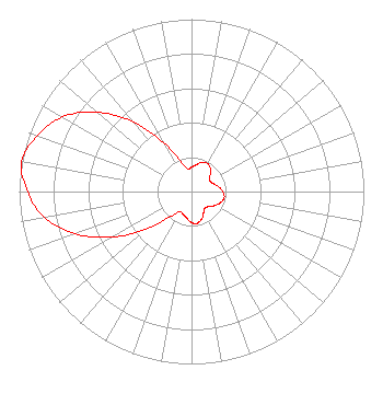 | ||||||||||||||||||
| Azimuth | Ratio | Azimuth | Ratio | Azimuth | Ratio | Azimuth | Ratio | ||||||||||||
| 0 | 0.142 | 10 | 0.157 | 20 | 0.181 | 30 | 0.187 | ||||||||||||
| 40 | 0.171 | 50 | 0.140 | 60 | 0.123 | 70 | 0.135 | ||||||||||||
| 80 | 0.160 | 90 | 0.182 | 100 | 0.193 | 110 | 0.182 | ||||||||||||
| 120 | 0.160 | 130 | 0.135 | 140 | 0.123 | 150 | 0.140 | ||||||||||||
| 160 | 0.171 | 170 | 0.187 | 180 | 0.181 | 190 | 0.157 | ||||||||||||
| 200 | 0.142 | 210 | 0.134 | 220 | 0.190 | 230 | 0.329 | ||||||||||||
| 240 | 0.528 | 250 | 0.718 | 260 | 0.866 | 270 | 0.952 | ||||||||||||
| 280 | 1.000 | 290 | 0.952 | 300 | 0.866 | 310 | 0.718 | ||||||||||||
| 320 | 0.528 | 330 | 0.329 | 340 | 0.190 | 350 | 0.134 | ||||||||||||
Structure Registration Number 1026617 Structure Type: TOWER Registered To: Bold Gold Media Group WBS, L.P. Structure Address: Sw Intersection Of Interstate 81 And Route 315 Wilkes-barre, PA County Name: Luzerne County ASR Issued: 03/01/2007 Date Built: 10/01/1994 Site Elevation: 279.8 m (918 ft.) Structure Height: 60.7 m (199 ft.) Height Overall: 60.7 m (199 ft.) Overall Height AMSL: 340.5 m (1117 ft.) FAA Determination: 08/03/1994 FAA Study #: 94-AEA-1034-OE Paint & Light FAA Chapters: NONE 41-15-01.0 N 75-49-31.0 W (NAD 83) 41-15-00.7 N 75-49-32.3 W (Converted to NAD 27) |
C/o Vince Benedetto 575 Grove Street Honesdale, PA 18431 Phone: 570-253-1616 | Date: 12/26/2012 Application Certifier BOLD GOLD MEDIA GROUP, L.P. C/o Vince Benedetto 575 Grove Street Honesdale, PA 18431 Applicant CRAIG R. SEELIG 34 Evans Rd Honesdale, PA 18431 CONTRACT ENGINEER ROBERT LEWIS THOMPSON Smithwick & Belendiuk, P.c. 5028 Wisconsin Ave., Nw Suite 301 Washington, DC 20016 | |||||||||||||||||