
FCCInfo.com
A Service of Cavell, Mertz & Associates, Inc.
(855) FCC-INFO
|
|
|
|
|
||||||||||||||||
|
|
W250AZ Channel: 250D 97.9 MHz Raleigh, North Carolina Service: FX - A translator or application for a translator. Facility ID: 146926 Fac. Service: FX Programming Delivery Method: Unspecified Status: License Application Accepted: 08/31/2017 Application Granted: 09/06/2017 File Number: BLFT-20170831BCC License Expires: 00/00/0000 Prefix Type: This is a license for a translator Application Type: License To Cover FCC Website Links: LMS Facility Details This Application CDBS Application Other W250AZ Applications Other W250AZ Applications in CDBS Including Superseded Applications Mailing Address Correspondence for W250AZ Correspondence related to application BLFT-20170831BCC Service Contour - Open Street Map or USGS Map (60 dBu) Service Contour - KML / Google Earth (60 dBu) Class: D, A Noncommercial educational operating with no more than 10W Site Location: 35-48-13.5 N 78-37-26.0 W (NAD 83) Site Location: 35-48-13.0 N 78-37-27.0 W (Converted to NAD 27) Effective Radiated Power: 0.2 kW Horiz. ; 0.084 kW Vert. Transmitter Output Power: 0.23 kW Antenna Center HAAT: 0 m Antenna Center AMSL: 189 m (620 ft.) Antenna Center HAG: 118 m (387 ft.) Site Elevation: 71 m. (233 ft.) Height Overall*: 128 m (420 ft.) (* As Filed In This Application, may differ from ASR Data, Below.) Directional Antenna Antenna Make/Model: None Antenna ID: 127136 Polarization:
| ||||||||||||||||||
| Antenna Data for Antenna Id: 127136 W250AZ FX File: BLFT-20170831BCC None - Service: FX | 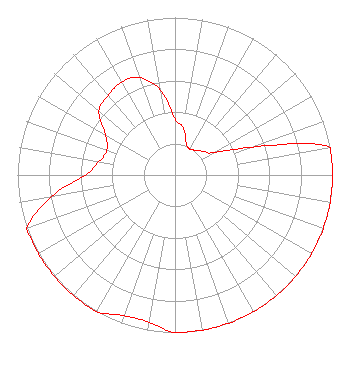 | ||||||||||||||||||
| Azimuth | Ratio | Azimuth | Ratio | Azimuth | Ratio | Azimuth | Ratio | ||||||||||||
| 0 | 0.360 | 10 | 0.305 | 20 | 0.210 | 30 | 0.190 | ||||||||||||
| 40 | 0.205 | 50 | 0.235 | 60 | 0.285 | 70 | 0.515 | ||||||||||||
| 80 | 1.000 | 90 | 1.000 | 100 | 1.000 | 110 | 1.000 | ||||||||||||
| 120 | 1.000 | 130 | 1.000 | 140 | 1.000 | 150 | 1.000 | ||||||||||||
| 160 | 1.000 | 170 | 1.000 | 180 | 1.000 | 190 | 0.950 | ||||||||||||
| 200 | 0.950 | 210 | 1.000 | 220 | 1.000 | 230 | 1.000 | ||||||||||||
| 240 | 1.000 | 250 | 1.000 | 260 | 0.795 | 270 | 0.570 | ||||||||||||
| 280 | 0.490 | 290 | 0.460 | 300 | 0.510 | 310 | 0.630 | ||||||||||||
| 320 | 0.660 | 330 | 0.680 | 340 | 0.660 | 350 | 0.550 | ||||||||||||
Structure Registration Number 1005746 Structure Type: LTOWER Registered To: TowerCo V Holdings LLC Structure Address: 1615 Old Louisburg Rd Raleigh, NC County Name: Wake County ASR Issued: 12/14/2023 Date Built: 01/01/1986 Site Elevation: 71.3 m (234 ft.) Structure Height: 121.9 m (400 ft.) Height Overall: 127.7 m (419 ft.) Overall Height AMSL: 199 m (653 ft.) FAA Determination: 06/05/2023 FAA Study #: 2022-ASO-41245-OE FAA Circular #: 70/7460-1J Paint & Light FAA Chapters: 4, 6, 13 OM&L to remain the same as prior study = 24-HR MED-STROBES 35-48-12.9 N 78-37-26.0 W (NAD 83) 35-48-12.4 N 78-37-27.0 W (Converted to NAD 27) |
1420 Brookside Dr. Raleigh, NC 27604 Phone: 919-931-1616 | Date: 08/31/2017 Application Certifier PMC BROADCASTING, LLC 1420 Brookside Dr Raleigh, NC 27604 Applicant TIMOTHY L. WARNER, P.E. Timothy L. Warner, Inc. Post Office Box 8045 Asheville, NC 28814-8045 TECHNICAL CONSULTANT DELORES STEWART Pmc Broadcasting, Llc 1420 Brookside Dr Raleigh, NC 27604 | |||||||||||||||||