
FCCInfo.com
A Service of Cavell, Mertz & Associates, Inc.
(855) FCC-INFO
|
|
|
|
|
||||||||||||||||
|
|
W263AW Channel: 263D 100.5 MHz Johnstown, Pennsylvania Service: FX - A translator or application for a translator. Facility ID: 140931 Fac. Service: FX Programming Delivery Method: Unspecified Status: License Application Accepted: 10/20/2006 Application Granted: 03/07/2007 File Number: BLFT-20061020ACJ License Expires: 00/00/0000 Prefix Type: This is a license for a translator Application Type: License To Cover FCC Website Links: LMS Facility Details This Application CDBS Application Other W263AW Applications Other W263AW Applications in CDBS Including Superseded Applications Mailing Address Correspondence for W263AW Correspondence related to application BLFT-20061020ACJ Service Contour - Open Street Map or USGS Map (60 dBu) Service Contour - KML / Google Earth (60 dBu) Class: D, A Noncommercial educational operating with no more than 10W Site Location: 40-22-15.3 N 78-59-01.1 W (NAD 83) Site Location: 40-22-15.0 N 78-59-02.0 W (Converted to NAD 27) Effective Radiated Power: 0.01 kW Transmitter Output Power: 0.03 kW Antenna Center HAAT: 340.4 m Horiz.; 0 m Vert. Antenna Center AMSL: 860 m (2822 ft.) Antenna Center HAG: 44 m (144 ft.) Site Elevation: 816 m. (2677 ft.) Height Overall*: 67 m (220 ft.) (* As Filed In This Application, may differ from ASR Data, Below.) Directional Antenna Antenna Make/Model: None Antenna ID: 16139 Polarization:
| ||||||||||||||||||
| Antenna Data for Antenna Id: 16139 W263AW FX File: BLFT-20061020ACJ None - Service: FX Pattern and Field Values Include a 135° Clockwise Rotation | 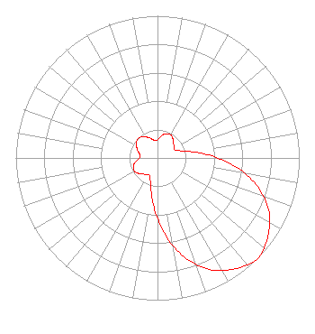 | ||||||||||||||||||
| Azimuth | Ratio | Azimuth | Ratio | Azimuth | Ratio | Azimuth | Ratio | ||||||||||||
| 5 | 0.140 | 15 | 0.171 | 25 | 0.187 | 35 | 0.181 | ||||||||||||
| 45 | 0.157 | 55 | 0.142 | 65 | 0.134 | 75 | 0.190 | ||||||||||||
| 85 | 0.329 | 95 | 0.528 | 105 | 0.718 | 115 | 0.866 | ||||||||||||
| 125 | 0.952 | 135 | 1.000 | 145 | 0.952 | 155 | 0.866 | ||||||||||||
| 165 | 0.718 | 175 | 0.528 | 185 | 0.329 | 195 | 0.190 | ||||||||||||
| 205 | 0.134 | 215 | 0.142 | 225 | 0.157 | 235 | 0.181 | ||||||||||||
| 245 | 0.187 | 255 | 0.171 | 265 | 0.140 | 275 | 0.123 | ||||||||||||
| 285 | 0.135 | 295 | 0.160 | 305 | 0.182 | 315 | 0.193 | ||||||||||||
| 325 | 0.182 | 335 | 0.160 | 345 | 0.135 | 355 | 0.123 | ||||||||||||
Structure Registration Number 1028041 [ASR Heights Differ from W263AW Application] Structure Type: TOWER Registered To: Crown Communications LLC Structure Address: Decker Ave Johnstown, PA County Name: Cambria County ASR Issued: 05/06/2016 Date Built: 10/28/1992 Site Elevation: 815.3 m (2675 ft.) Structure Height: 60.9 m (200 ft.) Height Overall: 68.3 m (224 ft.) Overall Height AMSL: 883.6 m (2899 ft.) FAA Determination: 07/22/2008 FAA Study #: 2008-AEA-3172-OE FAA Circular #: 70/7460-1J Paint & Light FAA Chapters: 4, 8, 13 PRIOR STUDY 2003-AEA-254-OE 40-22-15.5 N 78-59-00.8 W (NAD 83) 40-22-15.2 N 78-59-01.7 W (Converted to NAD 27) |
67 Bedford Square Pittsburgh, PA 15203 Phone: 412-381-9193 | Date: 10/20/2006 Application Certifier DUQUESNE UNIVERSITY 600 Forbes Ave Pittsburgh, PA 15219 Applicant CHARLES H LEAVENS II Duquesne University 600 Forbes Ave Pittsburgh, PA 15219 ENGINEER JEROLD L. JACOBS, ESQ. Cohn And Marks Llp 1920 N St., N.w. Suite 300 Washington, DC 20036-1622 | |||||||||||||||||