
FCCInfo.com
A Service of Cavell, Mertz & Associates, Inc.
(855) FCC-INFO
|
|
|
|
|
||||||||||||||||
|
|
KTOY Channel: 284A 104.7 MHz Texarkana, Arkansas Service: FM - A full-service FM station or application. Facility ID: 31348 Fac. Service: FM Status: License 73.215 Station Application Accepted: 11/17/2005 Application Granted: 12/05/2005 File Number: BLH-20051117AAA License Expires: 00/00/0000 Prefix Type: This is a license for a commercial FM station Application Type: Amendment FCC Website Links: LMS Facility Details This Application CDBS Application Other KTOY Applications Other KTOY Applications in CDBS Including Superseded Applications Mailing Address Correspondence for KTOY Correspondence related to application BLH-20051117AAA Service Contour - Open Street Map or USGS Map (60 dBu) Service Contour - KML / Google Earth (60 dBu) Public Inspection Files Facility Type: FM STATION Class: A, A Zone I; I-A; or II station; with 0.1kW-6kW ERP and a class contour distance <=28km Site Location: 33-25-45.4 N 94-07-11.7 W (NAD 83) Site Location: 33-25-45.0 N 94-07-11.0 W (Converted to NAD 27) Effective Radiated Power: 3.1 kW Transmitter Output Power: 1.37 kW Antenna Center HAAT: 138 m (453 ft.) Antenna Center AMSL: 230 m (755 ft.) Antenna Center HAG: 123 m (404 ft.) Calculated Site Elevation: 107 m. (351 ft.) Height Overall*: 137 m (449 ft.) (* As Filed In This Application, may differ from ASR Data, Below.) Directional Antenna Antenna Make/Model: Shivley 6810-3-DA Antenna ID: 69806 Polarization: | ||||||||||||||||||
| Antenna Data for Antenna Id: 69806 KTOY FM File: BLH-20051117AAA Shivley - 6810-3-DA Service: FM | 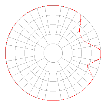 | ||||||||||||||||||
| Azimuth | Ratio | Azimuth | Ratio | Azimuth | Ratio | Azimuth | Ratio | ||||||||||||
| 0 | 1.000 | 10 | 1.000 | 20 | 1.000 | 30 | 1.000 | ||||||||||||
| 36 | 0.980 | 40 | 0.894 | 50 | 0.726 | 60 | 0.680 | ||||||||||||
| 70 | 0.712 | 80 | 0.850 | 87 | 0.999 | 90 | 1.000 | ||||||||||||
| 96 | 0.999 | 100 | 0.911 | 110 | 0.766 | 120 | 0.932 | ||||||||||||
| 123 | 0.999 | 130 | 1.000 | 140 | 1.000 | 150 | 1.000 | ||||||||||||
| 160 | 1.000 | 170 | 1.000 | 180 | 1.000 | 190 | 1.000 | ||||||||||||
| 200 | 1.000 | 210 | 1.000 | 220 | 1.000 | 230 | 1.000 | ||||||||||||
| 240 | 1.000 | 250 | 1.000 | 260 | 1.000 | 270 | 1.000 | ||||||||||||
| 280 | 1.000 | 290 | 1.000 | 300 | 1.000 | 310 | 1.000 | ||||||||||||
| 320 | 1.000 | 330 | 1.000 | 340 | 1.000 | 350 | 1.000 | ||||||||||||
Structure Registration Number 1053162 Structure Type: TOWER Registered To: Texarkana Radio Center Licenses, LLC Structure Address: .8 Km E Of Rt 989 @ Chaplewood Cemetary Texarkana, TX County Name: Bowie County ASR Issued: 05/03/2013 Date Built: 01/01/1984 Site Elevation: 106.7 m (350 ft.) Structure Height: 136.2 m (447 ft.) Height Overall: 137.2 m (450 ft.) Overall Height AMSL: 243.9 m (800 ft.) FAA Determination: 03/25/1983 FAA Study #: 83-ASW-172-OE Paint & Light FAA Chapters: 1, 3, 12, 21 RED LIGHTS/PAINT 33-25-45.0 N 94-07-12.0 W (NAD 83) 33-25-44.6 N 94-07-11.3 W (Converted to NAD 27) |
14206 Barbon Beck Ave. Bakersfield, CA 93311 Phone: 661-484-8051 Corporation | Date: 11/17/2005 Application Certifier JO-AL BROADCASTING, INC. 615 Olive Street Texarkana, TX 75501 Applicant SCOTT A. GRAY Gray Media Corporation 1031 Hickory Creek Dr Alexander, AR 72002 CONSULTANT SCOTT GRAY Gray Media Corporation | |||||||||||||||||
|
| ||||||||||||||||||