
FCCInfo.com
A Service of Cavell, Mertz & Associates, Inc.
(855) FCC-INFO
|
|
WBCG from 11/02/1998 |
|
|
||||||||||||||||
|
|
WBCG Channel: 255A 98.9 MHz Murdock, Florida Service: FM - A full-service FM station or application. Facility ID: 82071 Fac. Service: FM Status: License 73.215 Station Application Accepted: 08/03/2007 Application Granted: 12/03/2007 File Number: BLH-20070803ABP License Expires: 00/00/0000 Prefix Type: This is a license for a commercial FM station Application Type: Amendment FCC Website Links: LMS Facility Details This Application CDBS Application Other WBCG Applications Other WBCG Applications in CDBS Including Superseded Applications Mailing Address Correspondence for WBCG Correspondence related to application BLH-20070803ABP Service Contour - Open Street Map or USGS Map (60 dBu) Service Contour - KML / Google Earth (60 dBu) Public Inspection Files Facility Type: FM STATION Class: A, A Zone I; I-A; or II station; with 0.1kW-6kW ERP and a class contour distance <=28km Site Location: 27-00-10.2 N 82-10-53.3 W (NAD 83) Site Location: 27-00-09.0 N 82-10-54.0 W (Converted to NAD 27) Effective Radiated Power: 5.5 kW Transmitter Output Power: 2.8 kW Antenna Center HAAT: 104 m (341 ft.) Antenna Center AMSL: 106 m (348 ft.) Antenna Center HAG: 104 m (341 ft.) Calculated Site Elevation: 2 m. (7 ft.) Height Overall*: 108 m (354 ft.) (* As Filed In This Application, may differ from ASR Data, Below.) Directional Antenna Antenna Make/Model: Electronics Research Inc. LP-4E-DA-HW, four bays, 0.5 wavelength spacing Antenna ID: 78172 Polarization: | ||||||||||||||||||
| Antenna Data for Antenna Id: 78172 WBCG FM File: BLH-20070803ABP Electronics Research Inc. - LP-4E-DA-HW, four bays, 0.5 wavelength spacing Service: FM | 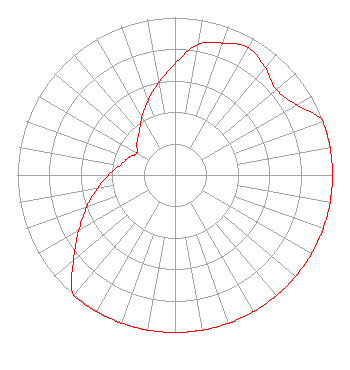 | ||||||||||||||||||
| Azimuth | Ratio | Azimuth | Ratio | Azimuth | Ratio | Azimuth | Ratio | ||||||||||||
| 0 | 0.707 | 10 | 0.841 | 20 | 0.891 | 30 | 0.933 | ||||||||||||
| 40 | 0.891 | 50 | 0.841 | 60 | 0.891 | 70 | 1.000 | ||||||||||||
| 80 | 1.000 | 90 | 1.000 | 100 | 1.000 | 110 | 1.000 | ||||||||||||
| 120 | 1.000 | 130 | 1.000 | 140 | 1.000 | 150 | 1.000 | ||||||||||||
| 160 | 1.000 | 170 | 1.000 | 180 | 1.000 | 190 | 1.000 | ||||||||||||
| 200 | 1.000 | 210 | 1.000 | 220 | 1.000 | 230 | 0.841 | ||||||||||||
| 240 | 0.707 | 250 | 0.595 | 260 | 0.501 | 270 | 0.421 | ||||||||||||
| 280 | 0.354 | 290 | 0.316 | 300 | 0.281 | 310 | 0.316 | ||||||||||||
| 320 | 0.354 | 330 | 0.421 | 340 | 0.501 | 350 | 0.595 | ||||||||||||
Structure Registration Number 1054432 [ASR Heights Differ from WBCG Application] Structure Type: GTOWER Registered To: Vertical Bridge CC FM, LLC Structure Address: 1770 Jenks Drive Murdock, FL County Name: Charlotte County ASR Issued: 12/19/2018 Date Built: 08/15/2001 Site Elevation: 2.8 m (9 ft.) Structure Height: 106 m (348 ft.) Height Overall: 106.3 m (349 ft.) Overall Height AMSL: 109.1 m (358 ft.) FAA Determination: 04/15/2014 FAA Study #: 2014-ASO-2868-OE FAA Circular #: 70/7460-1K Paint & Light FAA Chapters: 3, 4, 5, 12 PRIOR STUDY 1998-ASO-3905-OE 27-00-10.6 N 82-10-53.5 W (NAD 83) 27-00-09.4 N 82-10-54.2 W (Converted to NAD 27) |
7136 S. Yale Avenue Suite 501 Tulsa, OK 74136 Phone: 918-664-4581 | Date: 08/03/2007 Application Certifier CONCORD MEDIA GROUP, INC. 426 South River Road Tryon, NC 28782-7879 Applicant TROY LANGHAM 3762 S. Braden Ave Tulsa, OK 74135 ENGINEERING CONTRACTOR LEE W. SHUBERT, ESQ. Katten Muchin Rosenman Llp | |||||||||||||||||
| |||||||||||||||||||