
FCCInfo.com
A Service of Cavell, Mertz & Associates, Inc.
(855) FCC-INFO
|
|
WXKR from 05/21/1980 WXKR from 07/31/1979 |
|
|
|||||||||||||||||||
|
|
WXKR Channel: 233B 94.5 MHz Port Clinton, Ohio Service: FM - A full-service FM station or application. Facility ID: 69869 Fac. Service: FM Analog & Digital Status: License 73.215 Station Application Accepted: 09/10/2008 Application Granted: 10/14/2008 File Number: BLH-20080910ACQ License Expires: 00/00/0000 Prefix Type: This is a license for a commercial FM station Application Type: License To Cover FCC Website Links: LMS Facility Details This Application CDBS Application Other WXKR Applications Other WXKR Applications in CDBS Including Superseded Applications Mailing Address Correspondence for WXKR Correspondence related to application BLH-20080910ACQ Service Contour - Open Street Map or USGS Map (54 dBu) Service Contour - KML / Google Earth (54 dBu) Public Inspection Files History Cards for WXKR Facility Type: FM STATION Class: B, A Zone I or I-A station; with 25kW-50kW ERP and a class contour distance 39km-52km Site Location: 41-30-03.2 N 83-16-15.7 W (NAD 83) Site Location: 41-30-03.0 N 83-16-16.0 W (Converted to NAD 27) Effective Radiated Power: 30 kW Transmitter Output Power: 8.961 kW Antenna Center HAAT: 188.2 m (617 ft.) Antenna Center AMSL: 373.7 m (1226 ft.) Antenna Center HAG: 189 m (620 ft.) Calculated Site Elevation: 184.7 m. (606 ft.) Height Overall*: 195.8 m (642 ft.) (* As Filed In This Application, may differ from ASR Data, Below.) Directional Antenna Antenna Make/Model: Electronics Research Inc. FML-6E-DA-HW Antenna ID: 86912 Polarization:
| |||||||||||||||||||||
| Antenna Data for Antenna Id: 86912 WXKR FM File: BLH-20080910ACQ Electronics Research Inc. - FML-6E-DA-HW Service: FM | 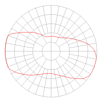 | |||||||||||||||||||||
| Azimuth | Ratio | Azimuth | Ratio | Azimuth | Ratio | Azimuth | Ratio | |||||||||||||||
| 0 | 0.319 | 10 | 0.329 | 20 | 0.330 | 30 | 0.340 | |||||||||||||||
| 40 | 0.375 | 45 | 0.410 | 50 | 0.445 | 60 | 0.538 | |||||||||||||||
| 70 | 0.660 | 80 | 0.830 | 90 | 0.950 | 100 | 1.000 | |||||||||||||||
| 110 | 1.000 | 120 | 1.000 | 130 | 0.930 | 135 | 0.850 | |||||||||||||||
| 140 | 0.770 | 150 | 0.648 | 160 | 0.564 | 170 | 0.515 | |||||||||||||||
| 180 | 0.486 | 190 | 0.497 | 200 | 0.530 | 210 | 0.591 | |||||||||||||||
| 220 | 0.678 | 225 | 0.733 | 230 | 0.787 | 240 | 0.910 | |||||||||||||||
| 250 | 1.000 | 260 | 1.000 | 270 | 1.000 | 280 | 1.000 | |||||||||||||||
| 290 | 0.986 | 300 | 0.800 | 310 | 0.640 | 315 | 0.575 | |||||||||||||||
| 320 | 0.510 | 330 | 0.410 | 340 | 0.330 | 350 | 0.320 | |||||||||||||||
Structure Registration Number 1065887 Structure Type: TOWER Registered To: VB Nimbus. LLC Structure Address: 3.2 Kilometers Northeast Of Elmore, OH County Name: Ottawa County ASR Issued: 12/03/2020 Date Built: 06/11/1999 Site Elevation: 184.7 m (606 ft.) Structure Height: 178.8 m (587 ft.) Height Overall: 195.8 m (642 ft.) Overall Height AMSL: 380.5 m (1248 ft.) FAA Determination: 06/10/1999 FAA Study #: 99-AGL-2162-OE Paint & Light FAA Chapters: 1, 3, 4, 13, 21 OM&L TO REMAIN PAINT/RED LIGHTS. 41-30-03.0 N 83-16-16.0 W (NAD 83) 41-30-02.8 N 83-16-16.3 W (Converted to NAD 27) |
780 Johnson Ferry Road Suite 500 Atlanta, GA 30342 Phone: 404-949-0700 Limited Liability Company | Date: 09/10/2008 Application Certifier CUMULUS LICENSING LLC 3280 Peachtree Road Nw Suite 2300 Atlanta, GA 30305 Applicant JEFFERSON G. BROCK Graham Brock, Inc. P. O. Box 24466 St. Simons Island, GA 31522-7466 TECHNICAL CONSULTANT MARK N. LIPP, ESQ. Wiley Rein Llp | ||||||||||||||||||||
|
| |||||||||||||||||||||