
FCCInfo.com
A Service of Cavell, Mertz & Associates, Inc.
(855) FCC-INFO
|
|
K224FF from 04/28/2016 K224FF from 12/13/2013 K224FF from 10/08/1998 |
|
|
||||||||||||||||
|
|
K224FF Channel: 224D 92.7 MHz Lenexa, Kansas Service: FX - A translator or application for a translator. Facility ID: 21063 Fac. Service: FX Programming Delivery Method: Unspecified Status: License Application Accepted: 07/24/2017 Application Granted: 07/28/2017 File Number: BLFT-20170724ABE License Expires: 00/00/0000 Prefix Type: This is a license for a translator Application Type: License To Cover FCC Website Links: LMS Facility Details This Application CDBS Application Other K224FF Applications Other K224FF Applications in CDBS Including Superseded Applications Mailing Address Correspondence for K224FF Correspondence related to application BLFT-20170724ABE Service Contour - Open Street Map or USGS Map (60 dBu) Service Contour - KML / Google Earth (60 dBu) Class: D, A Noncommercial educational operating with no more than 10W Site Location: 39-00-58.0 N 94-41-23.9 W (NAD 83) Site Location: 39-00-58.0 N 94-41-23.0 W (Converted to NAD 27) Effective Radiated Power: 0.099 kW Transmitter Output Power: 0.119 kW Antenna Center HAAT: 0 m Antenna Center AMSL: 392 m (1286 ft.) Antenna Center HAG: 80 m (262 ft.) Site Elevation: 312 m. (1024 ft.) Height Overall*: 107 m (351 ft.) (* As Filed In This Application, may differ from ASR Data, Below.) Directional Antenna Antenna Make/Model: None Antenna ID: 125381 Polarization:
| ||||||||||||||||||
| Antenna Data for Antenna Id: 125381 K224FF FX File: BLFT-20170724ABE None - Service: FX | 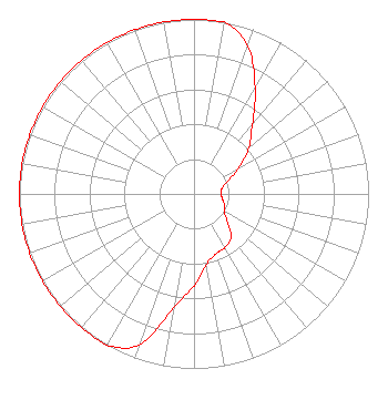 | ||||||||||||||||||
| Azimuth | Ratio | Azimuth | Ratio | Azimuth | Ratio | Azimuth | Ratio | ||||||||||||
| 0 | 1.000 | 10 | 1.000 | 20 | 0.900 | 30 | 0.700 | ||||||||||||
| 40 | 0.520 | 50 | 0.410 | 60 | 0.300 | 70 | 0.200 | ||||||||||||
| 80 | 0.160 | 90 | 0.155 | 100 | 0.166 | 110 | 0.185 | ||||||||||||
| 120 | 0.200 | 130 | 0.250 | 140 | 0.328 | 150 | 0.355 | ||||||||||||
| 160 | 0.365 | 170 | 0.411 | 180 | 0.527 | 190 | 0.660 | ||||||||||||
| 200 | 0.920 | 210 | 1.000 | 220 | 1.000 | 230 | 1.000 | ||||||||||||
| 240 | 1.000 | 250 | 1.000 | 260 | 1.000 | 270 | 1.000 | ||||||||||||
| 280 | 1.000 | 290 | 1.000 | 300 | 1.000 | 310 | 1.000 | ||||||||||||
| 320 | 1.000 | 330 | 1.000 | 340 | 1.000 | 350 | 1.000 | ||||||||||||
Structure Registration Number 1030961 Structure Type: LTOWER Registered To: American Towers LLC Structure Address: 6230 Ikea Way (90332) Shawnee Mission, KS County Name: Johnson County ASR Issued: 10/03/2022 Date Built: 04/09/2013 Site Elevation: 311.8 m (1023 ft.) Structure Height: 105.2 m (345 ft.) Height Overall: 106.7 m (350 ft.) Overall Height AMSL: 418.5 m (1373 ft.) FAA Determination: 09/29/2022 FAA Study #: 2021-ACE-10067-OE FAA Circular #: 70/7460-1K Paint & Light FAA Chapters: 4, 8, 12 PRIOR STUDY 2014-ACE-1392-OE 39-00-57.8 N 94-41-24.2 W (NAD 83) 39-00-57.8 N 94-41-23.3 W (Converted to NAD 27) |
636 Minnesota Avenue Kansas City, KS 66101 Phone: 913-563-0148 Not-for-Profit | Date: 07/24/2017 Application Certifier VISION COMMUNICATIONS, INCORPORATED 5431 West Sunshine Brookline Station, MO 65619 Applicant BERT GOLDMAN 560 Perkins Way Auburn, CA 95603 TECHNICAL CONSULTANT MICHAEL W. RICHARDS, ATTORNEY Law Office Of Michael W. Richards Lc Po Box 5842 Takoma Park, MD 20913-5842 | |||||||||||||||||