
FCCInfo.com
A Service of Cavell, Mertz & Associates, Inc.
(855) FCC-INFO
|
|
|
|
|
||||||||||||||||
|
|
K272FX Channel: 272D 102.3 MHz Eureka Springs, Arkansas Service: FX - A translator or application for a translator. Facility ID: 201165 Fac. Service: FX Programming Delivery Method: Unspecified Status: License Application Accepted: 07/09/2018 Application Granted: 07/11/2018 File Number: BLFT-20180709AAF License Expires: 00/00/0000 Prefix Type: This is a license for a translator Application Type: License To Cover FCC Website Links: LMS Facility Details This Application CDBS Application Other K272FX Applications Other K272FX Applications in CDBS Including Superseded Applications Mailing Address Correspondence for K272FX Correspondence related to application BLFT-20180709AAF Service Contour - Open Street Map or USGS Map (60 dBu) Service Contour - KML / Google Earth (60 dBu) Class: D, A Noncommercial educational operating with no more than 10W Site Location: 36-21-38.3 N 93-44-54.7 W (NAD 83) Site Location: 36-21-38.0 N 93-44-54.0 W (Converted to NAD 27) Effective Radiated Power: 0.14 kW Transmitter Output Power: 0.203 kW Antenna Center HAAT: 0 m Antenna Center AMSL: 566 m (1857 ft.) Antenna Center HAG: 66 m (217 ft.) Site Elevation: 500 m. (1640 ft.) Height Overall*: 81 m (266 ft.) (* As Filed In This Application, may differ from ASR Data, Below.) Directional Antenna Antenna Make/Model: None Antenna ID: 129913 Polarization:
| ||||||||||||||||||
| Antenna Data for Antenna Id: 129913 K272FX FX File: BLFT-20180709AAF None - Service: FX Pattern and Field Values Include a 60° Clockwise Rotation | 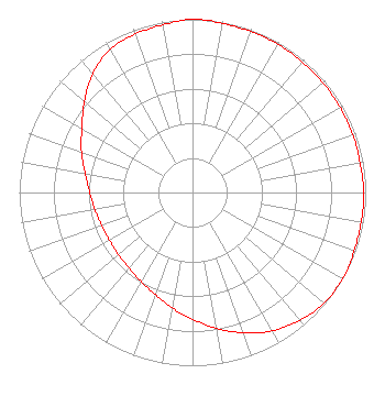 | ||||||||||||||||||
| Azimuth | Ratio | Azimuth | Ratio | Azimuth | Ratio | Azimuth | Ratio | ||||||||||||
| 0 | 1.000 | 10 | 0.992 | 20 | 0.988 | 30 | 0.988 | ||||||||||||
| 40 | 0.983 | 50 | 0.983 | 60 | 0.983 | 70 | 0.983 | ||||||||||||
| 80 | 0.983 | 90 | 0.988 | 100 | 0.988 | 110 | 0.992 | ||||||||||||
| 120 | 1.000 | 130 | 0.991 | 140 | 0.963 | 150 | 0.923 | ||||||||||||
| 160 | 0.862 | 170 | 0.797 | 180 | 0.731 | 190 | 0.676 | ||||||||||||
| 200 | 0.628 | 210 | 0.594 | 220 | 0.571 | 230 | 0.558 | ||||||||||||
| 240 | 0.553 | 250 | 0.558 | 260 | 0.571 | 270 | 0.594 | ||||||||||||
| 280 | 0.628 | 290 | 0.682 | 300 | 0.738 | 310 | 0.815 | ||||||||||||
| 320 | 0.897 | 330 | 0.953 | 340 | 0.973 | 350 | 0.983 | ||||||||||||
Structure Registration Number 1037669 Structure Type: TOWER Registered To: K2 Towers III, LLC Structure Address: 1.8 Mi S Jct Hwys 23 & 62 Eureka Springs, AR County Name: Carroll County ASR Issued: 03/04/2024 Date Built: 12/08/1995 Site Elevation: 500 m (1640 ft.) Structure Height: 73.1 m (240 ft.) Height Overall: 81.4 m (267 ft.) Overall Height AMSL: 581.4 m (1907 ft.) FAA Determination: 06/13/1995 FAA Study #: 95-ASW-0590-OE FAA Circular #: 70/7460-1H Paint & Light FAA Chapters: 3, 4, 5, 13 36-21-38.0 N 93-44-55.0 W (NAD 83) 36-21-37.7 N 93-44-54.3 W (Converted to NAD 27) |
111 Westwood Drive De Queen, AR 71832 Phone: 870-642-3637 | Date: 07/09/2018 Application Certifier CARROLL COUNTY BROADCASTING, INC. 111 Westwood Drive De Queen, AR 71832 Applicant DONALD LYNCH 111 Sam Houston Drive Kerrville, TX 78028 TECHNICAL CONSULTANT JAY BUNYARD Carroll County Broadcasting, Inc. 111 Westwood Drive Dequeen, AR 71832 | |||||||||||||||||