
FCCInfo.com
A Service of Cavell, Mertz & Associates, Inc.
(855) FCC-INFO
|
|
KDNR from 03/09/2007 KDNR from 03/27/2006 KDNR from 11/22/2003 KDNR from 06/19/2002 |
|  |
|
|||||||||||||||
|
|
KDNR Channel: 204A 88.7 MHz South Greeley, Wyoming Service: FM - A full-service FM station or application. Facility ID: 84104 Fac. Service: FM Status: License Application Accepted: 09/26/2017 Application Granted: 10/06/2017 File Number: BLED-20170926AFN License Expires: 00/00/0000 Prefix Type: This is a license for a noncommercial educational FM station Application Type: License To Cover FCC Website Links: LMS Facility Details This Application CDBS Application Other KDNR Applications Other KDNR Applications in CDBS Including Superseded Applications Mailing Address Correspondence for KDNR Correspondence related to application BLED-20170926AFN Service Contour - Open Street Map or USGS Map (60 dBu) Service Contour - KML / Google Earth (60 dBu) Public Inspection Files Facility Type: NON-COMMERCIAL EDUC. FM Class: A, A Zone I; I-A; or II station; with 0.1kW-6kW ERP and a class contour distance <=28km Site Location: 41-06-02.0 N 105-01-31.0 W (NAD 83) Site Location: 41-06-02.1 N 105-01-29.1 W (Converted to NAD 27) Effective Radiated Power: 2.5 kW Transmitter Output Power: 1.953 kW Antenna Center HAAT: 126.6 m (415 ft.) Antenna Center AMSL: 2153 m (7064 ft.) Antenna Center HAG: 70.3 m (231 ft.) Calculated Site Elevation: 2082.7 m. (6833 ft.) Height Overall*: 76.2 m (250 ft.) (* As Filed In This Application, may differ from ASR Data, Below.) Directional Antenna Antenna Make/Model: Electronics Research Inc. LP-2E-DA, two sections Antenna ID: 123587 Polarization: | ||||||||||||||||||
| Antenna Data for Antenna Id: 123587 KDNR FM File: BLED-20170926AFN Electronics Research Inc. - LP-2E-DA, two sections Service: FM | 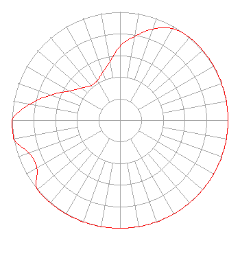 | ||||||||||||||||||
| Azimuth | Ratio | Azimuth | Ratio | Azimuth | Ratio | Azimuth | Ratio | ||||||||||||
| 0 | 0.684 | 10 | 0.788 | 20 | 0.897 | 30 | 0.976 | ||||||||||||
| 40 | 1.000 | 50 | 1.000 | 60 | 1.000 | 70 | 1.000 | ||||||||||||
| 80 | 1.000 | 90 | 1.000 | 100 | 1.000 | 110 | 1.000 | ||||||||||||
| 120 | 1.000 | 130 | 1.000 | 140 | 1.000 | 150 | 1.000 | ||||||||||||
| 160 | 1.000 | 170 | 1.000 | 180 | 1.000 | 190 | 1.000 | ||||||||||||
| 200 | 1.000 | 210 | 1.000 | 220 | 1.000 | 230 | 1.000 | ||||||||||||
| 240 | 0.889 | 250 | 0.894 | 260 | 1.000 | 270 | 1.000 | ||||||||||||
| 280 | 0.847 | 290 | 0.680 | 300 | 0.538 | 310 | 0.462 | ||||||||||||
| 320 | 0.417 | 330 | 0.423 | 340 | 0.468 | 350 | 0.545 | ||||||||||||
Structure Registration Number 1009309 Structure Type: Registered To: RF Towers, LLC Structure Address: 11 Mi W Cheyenne, WY County Name: Laramie County ASR Issued: 02/10/2024 Date Built: 01/01/1975 Site Elevation: 2082.7 m (6833 ft.) Structure Height: 76.2 m (250 ft.) Height Overall: 76.2 m (250 ft.) Overall Height AMSL: 2158.9 m (7083 ft.) FAA Determination: 11/12/1975 FAA Study #: 75-RM-378-OE Paint & Light FAA Chapters: 1, 3, 11, 21 41-06-02.0 N 105-01-31.0 W (NAD 83) 41-06-02.1 N 105-01-29.1 W (Converted to NAD 27) |
6363 Highway 50 East Carson City, NV 89701 Phone: 775-883-5647 Not-for-Profit | Date: 09/26/2017 Application Certifier WESTERN INSPIRATIONAL BROADCASTERS, INC. 6363 Hwy. 50 East Carson City, NV 89701 Applicant PAUL LIERMAN P.o. Box 18 Penney Farms, FL 32079 TECHNICAL CONSULTANT WESTERN INSPIRATIONAL BROADCASTERS, INC. Western Inspirational Broadcasters, Inc. | |||||||||||||||||