
FCCInfo.com
A Service of Cavell, Mertz & Associates, Inc.
(855) FCC-INFO
|
|
|
|
|
||||||||||||||||
|
|
W260BX Channel: 260D 99.9 MHz Lansing, Michigan Service: FX - A translator or application for a translator. Facility ID: 140610 Fac. Service: FX Programming Delivery Method: Unspecified Status: License Application Accepted: 10/26/2009 Application Granted: 11/16/2009 File Number: BLFT-20091026AAW License Expires: 00/00/0000 Prefix Type: This is a license for a translator Application Type: License To Cover FCC Website Links: LMS Facility Details This Application CDBS Application Other W260BX Applications Other W260BX Applications in CDBS Including Superseded Applications Mailing Address Correspondence for W260BX Correspondence related to application BLFT-20091026AAW Service Contour - Open Street Map or USGS Map (60 dBu) Service Contour - KML / Google Earth (60 dBu) Class: D, A Noncommercial educational operating with no more than 10W Site Location: 42-43-25.1 N 84-32-50.9 W (NAD 83) Site Location: 42-43-25.0 N 84-32-51.0 W (Converted to NAD 27) Effective Radiated Power: 0.19 kW Transmitter Output Power: 0.519 kW Antenna Center HAAT: 108.1 m Horiz.; 0 m Vert. Antenna Center AMSL: 370 m (1214 ft.) Antenna Center HAG: 114 m (374 ft.) Site Elevation: 256 m. (840 ft.) Height Overall*: 122 m (400 ft.) (* As Filed In This Application, may differ from ASR Data, Below.) Directional Antenna Antenna Make/Model: None Antenna ID: 92874 Polarization:
| ||||||||||||||||||
| Antenna Data for Antenna Id: 92874 W260BX FX File: BLFT-20091026AAW None - Service: FX Pattern and Field Values Include a 180° Clockwise Rotation | 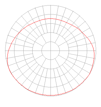 | ||||||||||||||||||
| Azimuth | Ratio | Azimuth | Ratio | Azimuth | Ratio | Azimuth | Ratio | ||||||||||||
| 0 | 0.702 | 10 | 0.702 | 20 | 0.702 | 30 | 0.712 | ||||||||||||
| 40 | 0.732 | 50 | 0.772 | 60 | 0.802 | 70 | 0.853 | ||||||||||||
| 80 | 0.909 | 90 | 0.953 | 100 | 0.973 | 110 | 0.983 | ||||||||||||
| 120 | 1.000 | 130 | 0.992 | 140 | 0.988 | 150 | 0.988 | ||||||||||||
| 160 | 0.983 | 170 | 0.983 | 180 | 0.983 | 190 | 0.983 | ||||||||||||
| 200 | 0.983 | 210 | 0.988 | 220 | 0.988 | 230 | 0.992 | ||||||||||||
| 240 | 1.000 | 250 | 0.991 | 260 | 0.963 | 270 | 0.923 | ||||||||||||
| 280 | 0.873 | 290 | 0.832 | 300 | 0.792 | 310 | 0.762 | ||||||||||||
| 320 | 0.732 | 330 | 0.710 | 340 | 0.702 | 350 | 0.702 | ||||||||||||
Structure Registration Number 1211449 [ASR Heights Differ from W260BX Application] Structure Type: GTOWER Registered To: SBA GC Towers, LLC Structure Address: 910 River Street (mi15916-a) Lansing, MI County Name: Ingham County ASR Issued: 02/15/2024 Date Built: 01/15/1993 Site Elevation: 253.3 m (831 ft.) Structure Height: 115.8 m (380 ft.) Height Overall: 118.9 m (390 ft.) Overall Height AMSL: 372.2 m (1221 ft.) FAA Determination: 12/01/2022 FAA Study #: 2022-AGL-1824-OE Paint & Light FAA Chapters: A2, H PRIOR STUDY 2014-AGL-5421-OE 42-43-25.0 N 84-32-51.8 W (NAD 83) 42-43-24.9 N 84-32-51.9 W (Converted to NAD 27) |
7355 North Oracle Road Tucson, AZ 85704 Phone: 520-219-7708 Not-for-Profit | Date: 10/26/2009 Application Certifier FAMILY LIFE BROADCASTING SYSTEM 7355 North Oracle Road Tucson, AZ 85704 Applicant MICHAEL K. BRINKS 7355 N. Oracle Road Tucson, AZ 85704 DIRECTOR OF SIGNAL DEVELOPMENT JOHN R. WILNER Fleischman And Harding Llp 1255 23rd Street, Nw Washington, DC 20037 | |||||||||||||||||