
FCCInfo.com
A Service of Cavell, Mertz & Associates, Inc.
(855) FCC-INFO
|
|
WVOS-FM from 01/12/1979 |
|  |
|
|||||||||||||||
|
|
WVOS-FM Channel: 240A 95.9 MHz Liberty, New York Service: FM - A full-service FM station or application. Facility ID: 43970 Fac. Service: FM Status: License Application Accepted: 05/21/2018 Application Granted: 05/31/2018 File Number: BMLH-20180521ABA License Expires: 00/00/0000 Prefix Type: This is a modification of a license for a commecial FM station Application Type: Minor Modification FCC Website Links: LMS Facility Details This Application CDBS Application Other WVOS-FM Applications Other WVOS-FM Applications in CDBS Including Superseded Applications Mailing Address Correspondence for WVOS-FM Correspondence related to application BMLH-20180521ABA Service Contour - Open Street Map or USGS Map (60 dBu) Service Contour - KML / Google Earth (60 dBu) Public Inspection Files History Cards for WVOS-FM Facility Type: FM STATION Class: A, A Zone I; I-A; or II station; with 0.1kW-6kW ERP and a class contour distance <=28km Site Location: 41-45-09.3 N 74-42-59.6 W (NAD 83) Site Location: 41-45-09.0 N 74-43-01.0 W (Converted to NAD 27) Effective Radiated Power: 6 kW Transmitter Output Power: 2.4 kW Antenna Center HAAT: 100 m (328 ft.) Antenna Center AMSL: 553 m (1814 ft.) Antenna Center HAG: 81 m (266 ft.) Calculated Site Elevation: 472 m. (1549 ft.) Height Overall*: 86 m (282 ft.) (* As Filed In This Application, may differ from ASR Data, Below.) Directional Antenna Antenna Make/Model: Shivley 6810-3R-DA Antenna ID: 14257 Polarization: | ||||||||||||||||||
| Antenna Data for Antenna Id: 14257 WVOS-FM FM File: BMLH-20180521ABA Shivley - 6810-3R-DA Service: FM | 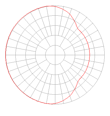 | ||||||||||||||||||
| Azimuth | Ratio | Azimuth | Ratio | Azimuth | Ratio | Azimuth | Ratio | ||||||||||||
| 0 | 0.980 | 10 | 0.935 | 20 | 0.875 | 30 | 0.785 | ||||||||||||
| 40 | 0.710 | 45 | 0.700 | 50 | 0.700 | 60 | 0.700 | ||||||||||||
| 70 | 0.700 | 80 | 0.700 | 90 | 0.700 | 100 | 0.700 | ||||||||||||
| 110 | 0.700 | 120 | 0.700 | 130 | 0.700 | 135 | 0.700 | ||||||||||||
| 140 | 0.720 | 150 | 0.800 | 160 | 0.880 | 170 | 0.940 | ||||||||||||
| 180 | 0.985 | 190 | 1.000 | 200 | 1.000 | 210 | 1.000 | ||||||||||||
| 220 | 1.000 | 230 | 1.000 | 240 | 1.000 | 250 | 1.000 | ||||||||||||
| 260 | 1.000 | 270 | 1.000 | 280 | 1.000 | 290 | 1.000 | ||||||||||||
| 300 | 1.000 | 310 | 1.000 | 320 | 1.000 | 330 | 1.000 | ||||||||||||
| 340 | 1.000 | 350 | 1.000 | ||||||||||||||||
Structure Registration Number 1240317 [ASR Heights Differ from WVOS-FM Application] Structure Type: TOWER Registered To: Seven Mountains Media, LLC Structure Address: Berwick Heights, Briar Creek Township Berwick, PA County Name: Columbia County ASR Issued: 02/12/2024 Date Built: 09/27/2004 Site Elevation: 284 m (932 ft.) Structure Height: 61.5 m (202 ft.) Height Overall: 61.5 m (202 ft.) Overall Height AMSL: 345.5 m (1134 ft.) FAA Determination: 08/11/2003 FAA Study #: 2003-AEA-2360-OE Paint & Light FAA Chapters: NONE PRIOR STUDY 2002-AEA-3309-OE 41-04-44.5 N 76-15-33.4 W (NAD 83) 41-04-44.2 N 76-15-34.6 W (Converted to NAD 27) |
575 Grove Street Honesdale, PA 18431 Phone: 570-253-1616 | Date: 05/21/2018 Application Certifier BOLD GOLD MEDIA GROUP, L.P. C/o Vince Benedetto 575 Grove Street Honesdale, PA 18431 Applicant MARK B. DENBO, ESQ. Smithwick & Belendiuk, P.c. CHARLES WILLIAMSON Digital Radio Engineering, Inc. Po Box 920 15 Neversink Drive Port Jervis, NY 12771 TECHNICAL CONSULTANT | |||||||||||||||||