
FCCInfo.com
A Service of Cavell, Mertz & Associates, Inc.
(855) FCC-INFO
|
|
|
|  |
|
|||||||||||||||
|
|
WNLD Channel: 201A 88.1 MHz Decatur, Illinois Service: FM - A full-service FM station or application. Facility ID: 28294 Fac. Service: FM Status: License Application Accepted: 12/02/1994 Application Granted: 07/18/1995 File Number: BLED-19941202KA License Expires: 00/00/0000 Prefix Type: This is a license for a noncommercial educational FM station Application Type: License To Cover FCC Website Links: LMS Facility Details This Application CDBS Application Other WNLD Applications Other WNLD Applications in CDBS Including Superseded Applications Mailing Address Correspondence for WNLD Correspondence related to application BLED-19941202KA Service Contour - Open Street Map or USGS Map (60 dBu) Service Contour - KML / Google Earth (60 dBu) Public Inspection Files Facility Type: NON-COMMERCIAL EDUC. FM Class: A, A Zone I; I-A; or II station; with 0.1kW-6kW ERP and a class contour distance <=28km Site Location: 39-48-35.1 N 88-59-31.3 W (NAD 83) Site Location: 39-48-35.0 N 88-59-31.0 W (Converted to NAD 27) Effective Radiated Power: 1 kW Transmitter Output Power: 0.46 kW Antenna Center HAAT: 93 m (305 ft.) Antenna Center AMSL: 291 m (955 ft.) Antenna Center HAG: 85 m (279 ft.) Calculated Site Elevation: 206 m. (676 ft.) Height Overall*: 152 m (499 ft.) (* As Filed In This Application, may differ from ASR Data, Below.) Directional Antenna Antenna Make/Model: Jampro JMPC-3 DA Antenna ID: 14337 Polarization: | ||||||||||||||||||
| Antenna Data for Antenna Id: 14337 WNLD FM File: BLED-19941202KA Jampro - JMPC-3 DA Service: FM | 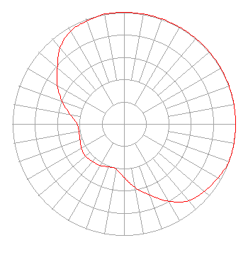 | ||||||||||||||||||
| Azimuth | Ratio | Azimuth | Ratio | Azimuth | Ratio | Azimuth | Ratio | ||||||||||||
| 0 | 1.000 | 10 | 1.000 | 20 | 1.000 | 30 | 1.000 | ||||||||||||
| 40 | 1.000 | 50 | 1.000 | 60 | 1.000 | 70 | 1.000 | ||||||||||||
| 80 | 1.000 | 90 | 1.000 | 100 | 1.000 | 110 | 1.000 | ||||||||||||
| 120 | 0.970 | 130 | 0.940 | 140 | 0.900 | 150 | 0.800 | ||||||||||||
| 160 | 0.680 | 170 | 0.580 | 180 | 0.480 | 190 | 0.410 | ||||||||||||
| 200 | 0.410 | 210 | 0.430 | 220 | 0.440 | 230 | 0.450 | ||||||||||||
| 240 | 0.440 | 250 | 0.420 | 260 | 0.410 | 270 | 0.420 | ||||||||||||
| 280 | 0.490 | 290 | 0.590 | 300 | 0.690 | 310 | 0.780 | ||||||||||||
| 320 | 0.890 | 330 | 0.960 | 340 | 0.980 | 350 | 1.000 | ||||||||||||
Structure Registration Number 1009085 Structure Type: TOWER Registered To: BURNS, MARY ELLEN DBA = WXFM RADIO Structure Address: 2420 Hulett Ln Decatur, IL County Name: Macon County ASR Issued: 02/20/1997 Date Built: 09/27/1984 Site Elevation: 205.7 m (675 ft.) Structure Height: 151.1 m (496 ft.) Height Overall: 152.1 m (499 ft.) Overall Height AMSL: 357.8 m (1174 ft.) Paint & Light FAA Chapters: 1, 3, 4, 13, 21 39-48-35.0 N 88-59-31.0 W (NAD 83) 39-48-34.9 N 88-59-30.7 W (Converted to NAD 27) |
3003 Snelling Ave N. St. Paul, MN 55133 Phone: 651-631-5009 Not-for-Profit | Date: 12/02/1994 Application Certifier ILLINOIS BIBLE INSTITUTE Illinois Bible Institute P.o. Box 140, Rr3 Carlinville, IL 62626 Applicant | |||||||||||||||||