
FCCInfo.com
A Service of Cavell, Mertz & Associates, Inc.
(855) FCC-INFO
|
|
|
|  |
|
|||||||||||||||
|
|
KTPD Channel: 207C3 89.3 MHz Del Rio, Texas Service: FM - A full-service FM station or application. Facility ID: 173346 Fac. Service: FM Status: License Application Accepted: 04/13/2016 Application Granted: 04/14/2016 File Number: BLED-20160413AAB License Expires: 00/00/0000 Prefix Type: This is a license for a noncommercial educational FM station Application Type: License To Cover FCC Website Links: LMS Facility Details This Application CDBS Application Other KTPD Applications Other KTPD Applications in CDBS Including Superseded Applications Mailing Address Correspondence for KTPD Correspondence related to application BLED-20160413AAB Service Contour - Open Street Map or USGS Map (60 dBu) Service Contour - KML / Google Earth (60 dBu) Public Inspection Files Facility Type: NON-COMMERCIAL EDUC. FM Class: C3, A Zone II station; with 6kW-25kW ERP and a class contour distance 28km-39km Site Location: 29-24-21.8 N 100-39-42.3 W (NAD 83) Site Location: 29-24-21.0 N 100-39-41.0 W (Converted to NAD 27) Effective Radiated Power: 25 kW Transmitter Output Power: 7.1 kW Antenna Center HAAT: 83 m (272 ft.) Antenna Center AMSL: 427 m (1401 ft.) Antenna Center HAG: 85 m (279 ft.) Calculated Site Elevation: 342 m. (1122 ft.) Height Overall*: 117 m (384 ft.) (* As Filed In This Application, may differ from ASR Data, Below.) Directional Antenna Antenna Make/Model: Shivley 6815-4-DA Antenna ID: 124009 Polarization:
| ||||||||||||||||||
| Antenna Data for Antenna Id: 124009 KTPD FM File: BLED-20160413AAB Shivley - 6815-4-DA Service: FM | 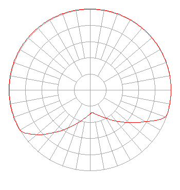 | ||||||||||||||||||
| Azimuth | Ratio | Azimuth | Ratio | Azimuth | Ratio | Azimuth | Ratio | ||||||||||||
| 0 | 1.000 | 10 | 1.000 | 20 | 1.000 | 30 | 1.000 | ||||||||||||
| 40 | 1.000 | 50 | 1.000 | 60 | 1.000 | 70 | 1.000 | ||||||||||||
| 80 | 1.000 | 90 | 1.000 | 100 | 1.000 | 110 | 0.985 | ||||||||||||
| 120 | 0.787 | 130 | 0.629 | 140 | 0.502 | 150 | 0.405 | ||||||||||||
| 160 | 0.340 | 170 | 0.297 | 175 | 0.284 | 180 | 0.301 | ||||||||||||
| 190 | 0.354 | 200 | 0.438 | 210 | 0.549 | 220 | 0.687 | ||||||||||||
| 230 | 0.860 | 240 | 1.000 | 250 | 1.000 | 260 | 1.000 | ||||||||||||
| 270 | 1.000 | 280 | 1.000 | 290 | 1.000 | 300 | 1.000 | ||||||||||||
| 310 | 1.000 | 320 | 1.000 | 330 | 1.000 | 340 | 1.000 | ||||||||||||
| 350 | 1.000 | ||||||||||||||||||
Structure Registration Number 1276326 Structure Type: TOWER Registered To: RF Services Inc Structure Address: 4 Miles North On Mud Creek Rd. Off Hwy 90 Amanda, TX County Name: Kinney County ASR Issued: 10/13/2010 Date Built: 10/22/2010 Site Elevation: 341.6 m (1121 ft.) Structure Height: 117 m (384 ft.) Height Overall: 117 m (384 ft.) Overall Height AMSL: 458.6 m (1505 ft.) FAA Determination: 10/12/2010 FAA Study #: 2010-ASW-5497-OE FAA Circular #: 70/7460-1K Paint & Light FAA Chapters: 3, 4, 5, 12 Removed expiration date from determination. Scenario 1./jjs/case#635066 29-24-21.8 N 100-39-42.3 W (NAD 83) 29-24-21.0 N 100-39-41.0 W (Converted to NAD 27) |
321 W Commerce St San Antonio, TX 78205 Phone: 210-614-8977 Not-for-Profit | Date: 04/13/2016 Application Certifier TEXAS PUBLIC RADIO 8401 Datapoint Dr. Suite 800 San Antonio, TX 78229-5903 Applicant WAYNE COBLE Texas Public Radio 8401 Datapoint Dr Ste 800 San Antonio, TX 78229-5903 VICE PRESIDENT BRAD C. DEUTSCH, ESQ. Garvey Schubert Barer | |||||||||||||||||