
FCCInfo.com
A Service of Cavell, Mertz & Associates, Inc.
(855) FCC-INFO
|
|
W251CF from 10/24/2003 |
|
|
||||||||||||||||
|
|
W251CF Channel: 251D 98.1 MHz Dover, New Hampshire Service: FX - A translator or application for a translator. Facility ID: 138295 Fac. Service: FX Programming Delivery Method: Unspecified Status: License Application Accepted: 11/14/2016 Application Granted: 11/28/2016 File Number: BLFT-20161114ACQ License Expires: 00/00/0000 Prefix Type: This is a license for a translator Application Type: License To Cover FCC Website Links: LMS Facility Details This Application CDBS Application Other W251CF Applications Other W251CF Applications in CDBS Including Superseded Applications Mailing Address Correspondence for W251CF Correspondence related to application BLFT-20161114ACQ Service Contour - Open Street Map or USGS Map (60 dBu) Service Contour - KML / Google Earth (60 dBu) Class: D, A Noncommercial educational operating with no more than 10W Site Location: 43-14-11.3 N 70-53-35.2 W (NAD 83) Site Location: 43-14-11.0 N 70-53-37.0 W (Converted to NAD 27) Effective Radiated Power: 0.25 kW Transmitter Output Power: 0.489 kW Antenna Center HAAT: 0 m Antenna Center AMSL: 125 m (410 ft.) Antenna Center HAG: 63 m (207 ft.) Site Elevation: 62 m. (203 ft.) Height Overall*: 90 m (295 ft.) (* As Filed In This Application, may differ from ASR Data, Below.) Directional Antenna Antenna Make/Model: None Antenna ID: 125174 Polarization:
| ||||||||||||||||||
| Antenna Data for Antenna Id: 125174 W251CF FX File: BLFT-20161114ACQ None - Service: FX | 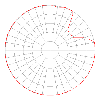 | ||||||||||||||||||
| Azimuth | Ratio | Azimuth | Ratio | Azimuth | Ratio | Azimuth | Ratio | ||||||||||||
| 0 | 1.000 | 10 | 0.973 | 20 | 1.000 | 30 | 1.000 | ||||||||||||
| 40 | 0.640 | 45 | 0.580 | 50 | 0.580 | 60 | 0.580 | ||||||||||||
| 65 | 0.650 | 70 | 0.802 | 80 | 1.000 | 90 | 1.000 | ||||||||||||
| 100 | 1.000 | 110 | 1.000 | 120 | 1.000 | 130 | 1.000 | ||||||||||||
| 140 | 1.000 | 150 | 1.000 | 160 | 1.000 | 170 | 1.000 | ||||||||||||
| 180 | 1.000 | 190 | 1.000 | 200 | 1.000 | 210 | 1.000 | ||||||||||||
| 220 | 1.000 | 230 | 1.000 | 240 | 1.000 | 250 | 1.000 | ||||||||||||
| 260 | 1.000 | 270 | 1.000 | 280 | 1.000 | 290 | 1.000 | ||||||||||||
| 300 | 1.000 | 310 | 1.000 | 320 | 1.000 | 330 | 1.000 | ||||||||||||
| 340 | 1.000 | 350 | 1.000 | ||||||||||||||||
Structure Registration Number 1033990 [ASR Heights Differ from W251CF Application] Structure Type: GTOWER Registered To: Robert L. Demers Revocable Trust of 2006 Structure Address: 120 Rt 108 Somersworth, NH County Name: Strafford County ASR Issued: 06/21/2021 Date Built: 01/01/1990 Site Elevation: 65.2 m (214 ft.) Structure Height: 90.5 m (297 ft.) Height Overall: 90.5 m (297 ft.) Overall Height AMSL: 155.7 m (511 ft.) FAA Determination: 07/25/2017 FAA Study #: 2017-ANE-2300-OE FAA Circular #: 70/7460-1H Paint & Light FAA Chapters: 3, 4, 5, 13 PRIOR STUDY 1993-ANE-51-OE 43-14-10.9 N 70-53-35.2 W (NAD 83) 43-14-10.6 N 70-53-37.0 W (Converted to NAD 27) |
126 Daniel St., Suite 200 Portsmouth, NH 03801 Phone: 603-431-0000 | Date: 11/14/2016 Application Certifier WBIN MEDIA CO., INC. 126 Daniel Street Suite 200 Portsmouth, NH 03801-3857 Applicant W. JEFFREY REYNOLDS Du Treil, Lundin & Rackley, Inc. 201 Fletcher Avenue Sarasota, FL 34237-6019 TECHNICAL CONSULTANT KATHLEEN VICTORY Fletcher Heald & Hildreth, Plc 1300 N. 17th Street Suite 1100 Arlington, VA 22209-3801 | |||||||||||||||||