
FCCInfo.com
A Service of Cavell, Mertz & Associates, Inc.
(855) FCC-INFO
|
|
K219LS from 06/30/2003 K219LS from 12/26/1996 K219LS from 04/16/1986 K219LS from 08/26/1981 |
|
|
||||||||||||||||
|
|
K219LS Channel: 219D 91.7 MHz Garberville, California Service: FX - A translator or application for a translator. Facility ID: 72005 Fac. Service: FX Programming Delivery Method: Unspecified Status: License Application Accepted: 05/16/2016 Application Granted: 06/02/2016 File Number: BLFT-20160516AAQ License Expires: 00/00/0000 Prefix Type: This is a license for a translator Application Type: License To Cover FCC Website Links: LMS Facility Details This Application CDBS Application Other K219LS Applications Other K219LS Applications in CDBS Including Superseded Applications Mailing Address Correspondence for K219LS Correspondence related to application BLFT-20160516AAQ Service Contour - Open Street Map or USGS Map (60 dBu) Service Contour - KML / Google Earth (60 dBu) Class: D, A Noncommercial educational operating with no more than 10W Site Location: 40-07-12.5 N 123-41-35.1 W (NAD 83) Site Location: 40-07-13.0 N 123-41-31.0 W (Converted to NAD 27) Effective Radiated Power: 0 kW Horiz. ; 0.01 kW Vert. Transmitter Output Power: 0.011 kW Antenna Center HAAT: 0 m Antenna Center AMSL: 0 m Horiz.; 1222 m Vert. Antenna Center HAG: 0 m Horiz.; 39 m Vert. Site Elevation: 1183 m. (3881 ft.) Height Overall*: 49 m (161 ft.) (* As Filed In This Application, may differ from ASR Data, Below.) Directional Antenna Antenna Make/Model: None Antenna ID: 31326 Polarization:
| ||||||||||||||||||
| Antenna Data for Antenna Id: 31326 K219LS FX File: BLFT-20160516AAQ None - Service: FX Pattern and Field Values Include a 300° Clockwise Rotation | 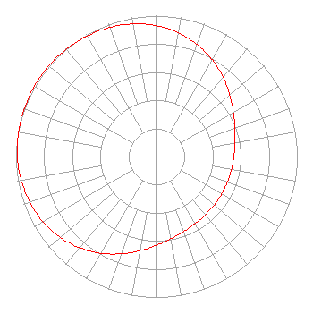 | ||||||||||||||||||
| Azimuth | Ratio | Azimuth | Ratio | Azimuth | Ratio | Azimuth | Ratio | ||||||||||||
| 0 | 0.929 | 10 | 0.892 | 20 | 0.845 | 30 | 0.792 | ||||||||||||
| 40 | 0.735 | 50 | 0.679 | 60 | 0.630 | 70 | 0.592 | ||||||||||||
| 80 | 0.566 | 90 | 0.549 | 100 | 0.540 | 110 | 0.535 | ||||||||||||
| 120 | 0.534 | 130 | 0.535 | 140 | 0.540 | 150 | 0.549 | ||||||||||||
| 160 | 0.566 | 170 | 0.592 | 180 | 0.630 | 190 | 0.679 | ||||||||||||
| 200 | 0.735 | 210 | 0.792 | 220 | 0.845 | 230 | 0.892 | ||||||||||||
| 240 | 0.929 | 250 | 0.956 | 260 | 0.975 | 270 | 0.987 | ||||||||||||
| 280 | 0.995 | 290 | 0.999 | 300 | 1.000 | 310 | 0.999 | ||||||||||||
| 320 | 0.995 | 330 | 0.987 | 340 | 0.975 | 350 | 0.956 | ||||||||||||
Structure Registration Number 1018930 Structure Type: LTOWER Structure Address: Alder Pt Rd Peak Pratt Mountain 8.53 Km E 2.25 Km N Of Garberville, CA County Name: Humboldt County ASR Issued: 05/26/2014 Date Built: 05/22/2007 Site Elevation: 1182.6 m (3880 ft.) Structure Height: 48.8 m (160 ft.) Height Overall: 48.8 m (160 ft.) Overall Height AMSL: 1231.4 m (4040 ft.) FAA Determination: 05/22/2007 FAA Study #: 2007-AWP-2742-OE FAA Circular #: 70/7460-1K Paint & Light FAA Chapters: 3, 4, 5, 12 OM&L to remain the same as prior study = PAINT/RED LIGHTS 40-07-12.4 N 123-41-35.2 W (NAD 83) 40-07-12.9 N 123-41-31.1 W (Converted to NAD 27) |
P.o. Box 391 4002 N. 3300 E. Twin Falls, ID 83303 Phone: 208-733-3133 | Date: 05/16/2016 Application Certifier CALVARY CHAPEL OF TWIN FALLS, INC. Po Box 391 Twin Falls, ID 83303 Applicant LOIS MILLS Po Box 391 Twin Falls, ID 83303 APPLICATION TECHNICIAN CARY TEPPER Tepper Law Firm, Llc 4900 Auburn Avenue, Suite 100 Bethesda, MD 20814-2632 | |||||||||||||||||