
FCCInfo.com
A Service of Cavell, Mertz & Associates, Inc.
(855) FCC-INFO
|
|
|
|
|
||||||||||||||||
|
|
WNUX Channel: 209B 89.7 MHz Montgomery, West Virginia Service: FM - A full-service FM station or application. Facility ID: 171273 Fac. Service: FM Status: License Application Accepted: 05/01/2013 Application Granted: 05/06/2013 File Number: BLED-20130501ACS License Expires: 00/00/0000 Prefix Type: This is a license for a noncommercial educational FM station Application Type: License To Cover FCC Website Links: LMS Facility Details This Application CDBS Application Other WNUX Applications Other WNUX Applications in CDBS Including Superseded Applications Mailing Address Correspondence for WNUX Correspondence related to application BLED-20130501ACS Service Contour - Open Street Map or USGS Map (60 dBu) Service Contour - KML / Google Earth (60 dBu) Public Inspection Files Facility Type: NON-COMMERCIAL EDUC. FM Class: B, A Zone I or I-A station; with 25kW-50kW ERP and a class contour distance 39km-52km Site Location: 37-56-51.0 N 81-18-28.0 W (NAD 83) Site Location: 37-56-50.6 N 81-18-28.6 W (Converted to NAD 27) Effective Radiated Power: 3.3 kW Transmitter Output Power: 1.3 kW Antenna Center HAAT: 416.6 m (1367 ft.) Antenna Center AMSL: 1007 m (3304 ft.) Antenna Center HAG: 26.2 m (86 ft.) Calculated Site Elevation: 980.8 m. (3218 ft.) Height Overall*: 57.9 m (190 ft.) (* As Filed In This Application, may differ from ASR Data, Below.) Directional Antenna Antenna Make/Model: Propagation System Inc FMR, two sections Antenna ID: 110084 Polarization: | ||||||||||||||||||
| Antenna Data for Antenna Id: 110084 WNUX FM File: BLED-20130501ACS Propagation System Inc - FMR, two sections Service: FM | 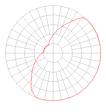 | ||||||||||||||||||
| Azimuth | Ratio | Azimuth | Ratio | Azimuth | Ratio | Azimuth | Ratio | ||||||||||||
| 0 | 0.376 | 10 | 0.475 | 20 | 0.601 | 30 | 0.760 | ||||||||||||
| 40 | 0.962 | 50 | 1.000 | 60 | 1.000 | 70 | 1.000 | ||||||||||||
| 80 | 1.000 | 90 | 1.000 | 100 | 1.000 | 110 | 1.000 | ||||||||||||
| 120 | 1.000 | 130 | 1.000 | 140 | 1.000 | 150 | 1.000 | ||||||||||||
| 160 | 1.000 | 170 | 1.000 | 180 | 1.000 | 190 | 1.000 | ||||||||||||
| 200 | 1.000 | 210 | 0.890 | 220 | 0.708 | 230 | 0.563 | ||||||||||||
| 240 | 0.448 | 250 | 0.356 | 260 | 0.283 | 270 | 0.225 | ||||||||||||
| 280 | 0.200 | 290 | 0.200 | 300 | 0.200 | 310 | 0.200 | ||||||||||||
| 320 | 0.200 | 330 | 0.190 | 340 | 0.235 | 350 | 0.297 | ||||||||||||
Structure Registration Number 1034515 Structure Type: TOWER Registered To: Southern Communications Corp. Structure Address: 1.75 Mi South Kingston, WV County Name: Raleigh County ASR Issued: 04/22/2004 Date Built: 07/24/1995 Site Elevation: 981.2 m (3219 ft.) Structure Height: 51.8 m (170 ft.) Height Overall: 57.9 m (190 ft.) Overall Height AMSL: 1039.1 m (3409 ft.) FAA Determination: 06/22/1995 FAA Study #: 95-AEA-0541-OE FAA Circular #: 70/7460-1H Paint & Light FAA Chapters: 3, 4, 5, 13 RED LIGHTS/PAINT 37-56-51.0 N 81-18-28.0 W (NAD 83) 37-56-50.6 N 81-18-28.6 W (Converted to NAD 27) |
Post Office Box 3744 Charleston, WV 25337 Phone: 304-345-2000 Not-for-Profit | Date: 05/01/2013 Application Certifier THE SAINT THOMAS MORE CATHOLIC LAWYERS SOCIETY, INC. P. O. Box 1746 Charleston, WV 25326 Applicant DAVID J DOHERTY Skywaves Consulting Llc Po Box 4 Millbury, MA 01527-0004 TECHNICAL CONSULTANT STUART W. NOLAN, JR. Legalworks Apostolate Pllc | |||||||||||||||||