
FCCInfo.com
A Service of Cavell, Mertz & Associates, Inc.
(855) FCC-INFO
|
|
W283CK from 03/16/2007 W283CK from 04/07/2004 |
|
|
||||||||||||||||
|
|
W283CK Channel: 283D 104.5 MHz West Springfield, Massachusetts Service: FX - A translator or application for a translator. Facility ID: 139393 Fac. Service: FX Programming Delivery Method: Unspecified Status: License Application Accepted: 04/11/2016 Application Granted: 04/18/2016 File Number: BLFT-20160411ABN License Expires: 00/00/0000 Prefix Type: This is a license for a translator Application Type: License To Cover FCC Website Links: LMS Facility Details This Application CDBS Application Other W283CK Applications Other W283CK Applications in CDBS Including Superseded Applications Mailing Address Correspondence for W283CK Correspondence related to application BLFT-20160411ABN Service Contour - Open Street Map or USGS Map (60 dBu) Service Contour - KML / Google Earth (60 dBu) Class: D, A Noncommercial educational operating with no more than 10W Site Location: 42-08-11.3 N 72-36-40.3 W (NAD 83) Site Location: 42-08-11.0 N 72-36-42.0 W (Converted to NAD 27) Effective Radiated Power: 0.25 kW Transmitter Output Power: 0.547 kW Antenna Center HAAT: 0 m Antenna Center AMSL: 92 m (302 ft.) Antenna Center HAG: 56 m (184 ft.) Site Elevation: 36 m. (118 ft.) Height Overall*: 61 m (200 ft.) (* As Filed In This Application, may differ from ASR Data, Below.) Directional Antenna Antenna Make/Model: None Antenna ID: 123247 Polarization:
| ||||||||||||||||||
| Antenna Data for Antenna Id: 123247 W283CK FX File: BLFT-20160411ABN None - Service: FX | 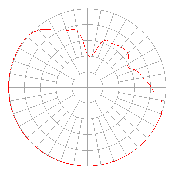 | ||||||||||||||||||
| Azimuth | Ratio | Azimuth | Ratio | Azimuth | Ratio | Azimuth | Ratio | ||||||||||||
| 0 | 0.421 | 10 | 0.432 | 20 | 0.629 | 30 | 0.640 | ||||||||||||
| 40 | 0.667 | 50 | 0.672 | 60 | 0.597 | 65 | 0.580 | ||||||||||||
| 70 | 0.648 | 80 | 0.717 | 90 | 0.810 | 95 | 0.860 | ||||||||||||
| 100 | 0.955 | 110 | 1.000 | 120 | 1.000 | 130 | 1.000 | ||||||||||||
| 140 | 1.000 | 150 | 1.000 | 160 | 1.000 | 170 | 1.000 | ||||||||||||
| 180 | 1.000 | 190 | 1.000 | 200 | 1.000 | 210 | 1.000 | ||||||||||||
| 220 | 1.000 | 230 | 1.000 | 240 | 1.000 | 250 | 1.000 | ||||||||||||
| 260 | 1.000 | 270 | 1.000 | 280 | 1.000 | 290 | 1.000 | ||||||||||||
| 300 | 1.000 | 310 | 1.000 | 320 | 0.950 | 330 | 0.840 | ||||||||||||
| 340 | 0.770 | 350 | 0.720 | ||||||||||||||||
Structure Registration Number 1222934 Structure Type: LTOWER Registered To: Industrial Tower and Wireless, LLC Structure Address: 481 Center Street Chicopee, MA County Name: Hampden County ASR Issued: 03/06/2023 Date Built: 07/19/2002 Site Elevation: 36.5 m (120 ft.) Structure Height: 57.9 m (190 ft.) Height Overall: 60.9 m (200 ft.) Overall Height AMSL: 97.4 m (320 ft.) FAA Determination: 03/01/2023 FAA Study #: 2022-ANE-2151-OE Paint & Light FAA Chapters: NONE PRIOR STUDY 2000-ANE-875-OE 42-08-12.4 N 72-36-40.1 W (NAD 83) 42-08-12.1 N 72-36-41.8 W (Converted to NAD 27) |
Po Box 357 758 Colonel Ledyard Highway Ledyard, CT 06339 Phone: 860-883-4292 | Date: 04/11/2016 Application Certifier RED WOLF BROADCASTING CORPORATION 758 Colonel Ledyard Highway P.o. Box 357 Ledyard, CT 06339 Applicant W. JEFFREY REYNOLDS Du Treil, Lundin & Rackley, Inc. 201 Fletcher Avenue Sarasota, FL 34237-6019 TECHNICAL CONSULTANT SCOTT WOODWORTH Edinger Associates Pllc 1875 I Street Nw Suite 500 Washington, DC 20006 | |||||||||||||||||