
FCCInfo.com
A Service of Cavell, Mertz & Associates, Inc.
(855) FCC-INFO
|
|
|
|  |
|
|||||||||||||||
|
|
KBMJ Channel: 208C1 89.5 MHz Heber Springs, Arkansas Service: FM - A full-service FM station or application. Facility ID: 87466 Fac. Service: FM Status: License Application Accepted: 07/15/2005 Application Granted: 09/19/2005 File Number: BLED-20050715AAG License Expires: 00/00/0000 Prefix Type: This is a license for a noncommercial educational FM station Application Type: Amendment FCC Website Links: LMS Facility Details This Application CDBS Application Other KBMJ Applications Other KBMJ Applications in CDBS Including Superseded Applications Mailing Address Correspondence for KBMJ Correspondence related to application BLED-20050715AAG Service Contour - Open Street Map or USGS Map (60 dBu) Service Contour - KML / Google Earth (60 dBu) Public Inspection Files Facility Type: NON-COMMERCIAL EDUC. FM Class: C1, A Zone II station; with 50kW-100kW ERP and a class contour distance 52km-72km Site Location: 35-44-00.3 N 92-15-37.6 W (NAD 83) Site Location: 35-44-00.0 N 92-15-37.0 W (Converted to NAD 27) Effective Radiated Power: 0 kW Horiz. ; 70 kW Vert. Transmitter Output Power: 6.35 kW Antenna Center HAAT: 0 m Horiz.; 224 m Vert. Antenna Center AMSL: 0 m Horiz.; 540 m Vert. Antenna Center HAG: 0 m Horiz.; 107 m Vert. Site Elevation: 433 m. (1421 ft.) Height Overall*: 152 m (499 ft.) (* As Filed In This Application, may differ from ASR Data, Below.) Directional Antenna Antenna Make/Model: Shivley 6513-8-DA, 8 SECTIONS Antenna ID: 68708 Polarization:
| ||||||||||||||||||
| Antenna Data for Antenna Id: 68708 KBMJ FM File: BLED-20050715AAG Shivley - 6513-8-DA, 8 SECTIONS Service: FM | 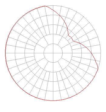 | ||||||||||||||||||
| Azimuth | Ratio | Azimuth | Ratio | Azimuth | Ratio | Azimuth | Ratio | ||||||||||||
| 0 | 0.900 | 10 | 0.800 | 20 | 0.700 | 30 | 0.600 | ||||||||||||
| 40 | 0.500 | 50 | 0.500 | 60 | 0.500 | 70 | 0.600 | ||||||||||||
| 80 | 0.700 | 90 | 0.800 | 100 | 0.900 | 110 | 1.000 | ||||||||||||
| 120 | 1.000 | 130 | 1.000 | 140 | 1.000 | 150 | 1.000 | ||||||||||||
| 160 | 1.000 | 170 | 1.000 | 180 | 1.000 | 190 | 1.000 | ||||||||||||
| 200 | 1.000 | 210 | 1.000 | 220 | 1.000 | 230 | 1.000 | ||||||||||||
| 240 | 1.000 | 250 | 1.000 | 260 | 1.000 | 270 | 1.000 | ||||||||||||
| 280 | 1.000 | 290 | 1.000 | 300 | 1.000 | 310 | 1.000 | ||||||||||||
| 320 | 1.000 | 330 | 1.000 | 340 | 1.000 | 350 | 1.000 | ||||||||||||
Structure Registration Number 1025324 Structure Type: TOWER Registered To: Freedom Broadcasting, Inc. Structure Address: Hwy 9 Rushing, AR County Name: Stone County ASR Issued: 10/04/2022 Date Built: 01/01/1989 Site Elevation: 432.6 m (1419 ft.) Structure Height: 152.4 m (500 ft.) Height Overall: 152.4 m (500 ft.) Overall Height AMSL: 585 m (1919 ft.) FAA Determination: 01/04/1990 FAA Study #: 89-ASW-1862-OE FAA Circular #: 70/7460-1G Paint & Light FAA Chapters: 3, 4, 5, 9 35-44-00.0 N 92-15-38.0 W (NAD 83) 35-43-59.7 N 92-15-37.4 W (Converted to NAD 27) |
P.o. Drawer 2440 Tupelo, MS 38801-2440 Phone: 662-844-8888 Not-for-Profit | Date: 07/15/2005 Application Certifier AMERICAN FAMILY ASSOCIATION Great Lakes Broadcast Academy, Inc. P.o. Drawer 2440 Tupelo, MS 38801 Applicant MARSHA SHRADER American Family Association P.o. Drawer 2440 Tupelo, MS 38803 TECHNICAL CONSULTANT MARSHA SHRADER American Family Association | |||||||||||||||||