
FCCInfo.com
A Service of Cavell, Mertz & Associates, Inc.
(855) FCC-INFO
|
|
K209FS from 09/14/1989 |
|
|
||||||||||||||||
|
|
K209FS Channel: 209D 89.7 MHz Columbus, Nebraska Service: FX - A translator or application for a translator. Facility ID: 47960 Fac. Service: FX Programming Delivery Method: Unspecified Status: License (Licensed And Silent) Application Accepted: 01/31/2014 Application Granted: 02/25/2014 File Number: BLFT-20140131ABB License Expires: 00/00/0000 Prefix Type: This is a license for a translator Application Type: License To Cover FCC Website Links: LMS Facility Details This Application CDBS Application Other K209FS Applications Other K209FS Applications in CDBS Including Superseded Applications Mailing Address Correspondence for K209FS Correspondence related to application BLFT-20140131ABB Service Contour - Open Street Map or USGS Map (60 dBu) Service Contour - KML / Google Earth (60 dBu) Class: D, A Noncommercial educational operating with no more than 10W Site Location: 41-26-21.0 N 97-23-45.2 W (NAD 83) Site Location: 41-26-21.0 N 97-23-44.0 W (Converted to NAD 27) Effective Radiated Power: 0 kW Horiz. ; 0.039 kW Vert. Transmitter Output Power: 0.02 kW Antenna Center HAAT: 50.4 m Horiz.; 0 m Vert. Antenna Center AMSL: 0 m Horiz.; 503 m Vert. Antenna Center HAG: 0 m Horiz.; 58 m Vert. Site Elevation: 445 m. (1460 ft.) Height Overall*: 87 m (285 ft.) (* As Filed In This Application, may differ from ASR Data, Below.) Directional Antenna Antenna Make/Model: None Antenna ID: 113522 Polarization:
| ||||||||||||||||||
| Antenna Data for Antenna Id: 113522 K209FS FX File: BLFT-20140131ABB None - Service: FX | 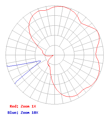 | ||||||||||||||||||
| Azimuth | Ratio | Azimuth | Ratio | Azimuth | Ratio | Azimuth | Ratio | ||||||||||||
| 0 | 0.971 | 10 | 0.990 | 20 | 0.971 | 30 | 0.917 | ||||||||||||
| 40 | 0.845 | 50 | 0.903 | 60 | 0.990 | 70 | 0.971 | ||||||||||||
| 80 | 0.883 | 90 | 0.845 | 100 | 0.913 | 110 | 0.971 | ||||||||||||
| 120 | 0.990 | 130 | 0.971 | 140 | 0.917 | 150 | 0.932 | ||||||||||||
| 160 | 0.903 | 170 | 0.806 | 180 | 0.631 | 190 | 0.427 | ||||||||||||
| 200 | 0.272 | 210 | 0.243 | 220 | 0.214 | 230 | 0.146 | ||||||||||||
| 240 | 0.049 | 250 | 0.039 | 260 | 0.136 | 270 | 0.204 | ||||||||||||
| 280 | 0.243 | 290 | 0.272 | 300 | 0.437 | 310 | 0.650 | ||||||||||||
| 320 | 0.806 | 330 | 0.903 | 340 | 0.942 | 350 | 0.922 | ||||||||||||
Structure Registration Number 1040699 Structure Type: LTOWER Registered To: PLATTE, COUNTY OF Structure Address: Sw1/4 Of Se1/4 Of Sect 14 Twp17n Range 1w Columbus, NE County Name: Platte County ASR Issued: 04/28/2023 Date Built: 01/01/1950 Site Elevation: 445.1 m (1460 ft.) Structure Height: 86.6 m (284 ft.) Height Overall: 86.6 m (284 ft.) Overall Height AMSL: 531.7 m (1744 ft.) FAA Determination: 12/14/2022 FAA Study #: 2022-ACE-7172-OE Paint & Light FAA Chapters: A1, H, 3, 11, 21, 23 PRIOR STUDY 1989-ACE-665-OE 41-26-21.6 N 97-23-48.1 W (NAD 83) 41-26-21.6 N 97-23-46.9 W (Converted to NAD 27) |
1800 N. 33rd Street Lincoln, NE 68503 Phone: 402-472-9333 Government Entity | Date: 01/31/2014 Application Certifier NEBRASKA EDUCATIONAL TELECOMMUNICATIONS COMMISSION 1800 N. 33rd Street Lincoln, NE 68503 Applicant ROGER BOOK 1800 North 33rd Street Lincoln, NE 68503 ENGINEER BARRY PERSH Gray Miller Persh Llp 1200 New Hampshire Ave, Nw Washington, DC 20036-6802 | |||||||||||||||||