
FCCInfo.com
A Service of Cavell, Mertz & Associates, Inc.
(855) FCC-INFO
|
|
|
|  |
|
||||||||||||||||||
|
|
KBIU Channel: 277C2 103.3 MHz Lake Charles, Louisiana Service: FM - A full-service FM station or application. Facility ID: 17019 Fac. Service: FM Status: License 73.215 Station Application Accepted: 06/12/2019 Application Granted: 06/13/2019 File Number: BLH-20190612AAS License Expires: 00/00/0000 Prefix Type: This is a license for a commercial FM station Application Type: License To Cover FCC Website Links: LMS Facility Details This Application CDBS Application Other KBIU Applications Other KBIU Applications in CDBS Including Superseded Applications Mailing Address Correspondence for KBIU Correspondence related to application BLH-20190612AAS Service Contour - Open Street Map or USGS Map (60 dBu) Service Contour - KML / Google Earth (60 dBu) Public Inspection Files History Cards for KBIU Facility Type: FM STATION Class: C2, A Zone II station; with 25kW-50kW ERP and a class contour distance 39km-52km Site Location: 30-14-36.7 N 93-20-38.6 W (NAD 83) Site Location: 30-14-36.0 N 93-20-38.0 W (Converted to NAD 27) Effective Radiated Power: 50 kW Transmitter Output Power: 10.5 kW Antenna Center HAAT: 115 m (377 ft.) Antenna Center AMSL: 119.1 m (391 ft.) Antenna Center HAG: 114.5 m (376 ft.) Calculated Site Elevation: 4.6 m. (15 ft.) Height Overall*: 158.5 m (520 ft.) (* As Filed In This Application, may differ from ASR Data, Below.) Directional Antenna Antenna Make/Model: Shivley 6810-6-DA Antenna ID: 134445 Polarization: | |||||||||||||||||||||
| Antenna Data for Antenna Id: 134445 KBIU FM File: BLH-20190612AAS Shivley - 6810-6-DA Service: FM | 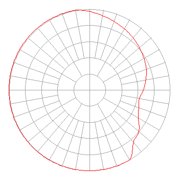 | |||||||||||||||||||||
| Azimuth | Ratio | Azimuth | Ratio | Azimuth | Ratio | Azimuth | Ratio | |||||||||||||||
| 0 | 0.970 | 10 | 0.930 | 20 | 0.900 | 30 | 0.870 | |||||||||||||||
| 40 | 0.840 | 50 | 0.810 | 60 | 0.780 | 70 | 0.750 | |||||||||||||||
| 80 | 0.710 | 90 | 0.670 | 100 | 0.630 | 110 | 0.650 | |||||||||||||||
| 120 | 0.700 | 130 | 0.800 | 140 | 0.850 | 150 | 1.000 | |||||||||||||||
| 160 | 1.000 | 170 | 1.000 | 180 | 1.000 | 190 | 1.000 | |||||||||||||||
| 200 | 1.000 | 210 | 1.000 | 220 | 1.000 | 230 | 1.000 | |||||||||||||||
| 240 | 1.000 | 250 | 1.000 | 260 | 1.000 | 270 | 1.000 | |||||||||||||||
| 280 | 1.000 | 290 | 1.000 | 300 | 1.000 | 310 | 1.000 | |||||||||||||||
| 320 | 1.000 | 330 | 1.000 | 340 | 1.000 | 350 | 1.000 | |||||||||||||||
Structure Registration Number 1022750 Structure Type: GTOWER Registered To: VB Nimbus, LLC Structure Address: 2730 E Burton (us-la-5105) Sulphur, LA County Name: Calcasieu Parish ASR Issued: 05/26/2021 Date Built: 01/01/1996 Site Elevation: 4.6 m (15 ft.) Structure Height: 157.6 m (517 ft.) Height Overall: 158.5 m (520 ft.) Overall Height AMSL: 163.1 m (535 ft.) FAA Determination: 05/10/2019 FAA Study #: 2019-ASW-4236-OE FAA Circular #: 70/7460-1L Paint & Light FAA Chapters: 4, 8, 12 30-14-36.8 N 93-20-38.7 W (NAD 83) 30-14-36.1 N 93-20-38.1 W (Converted to NAD 27) |
780 Johnson Ferry Road Suite 500 Atlanta, GA 30342 Phone: 404-949-0700 Limited Liability Company | Date: 06/12/2019 Application Certifier CUMULUS LICENSING LLC 3280 Peachtree Road, Nw Suite 2200 Atlanta, GA 30305 Applicant WILLIAM J. GETZ Carl T. Jones Corporation 7901 Yarnwood Court Springfield, VA 22153 CONSULTING ENGINEER ANDREW S. KERSTING, ESQ. Cumulus Media Inc. | ||||||||||||||||||||
|
| |||||||||||||||||||||