
FCCInfo.com
A Service of Cavell, Mertz & Associates, Inc.
(855) FCC-INFO
|
|
K223BM from 06/22/2004 |
|
|
||||||||||||||||
|
|
K223BM Channel: 223D 92.5 MHz Warren, Arkansas Service: FX - A translator or application for a translator. Facility ID: 150849 Fac. Service: FX Programming Delivery Method: Unspecified Status: License Application Accepted: 03/15/2011 Application Granted: 03/31/2011 File Number: BLFT-20110315ABI License Expires: 00/00/0000 Prefix Type: This is a license for a translator Application Type: License To Cover FCC Website Links: LMS Facility Details This Application CDBS Application Other K223BM Applications Other K223BM Applications in CDBS Including Superseded Applications Mailing Address Correspondence for K223BM Correspondence related to application BLFT-20110315ABI Service Contour - Open Street Map or USGS Map (60 dBu) Service Contour - KML / Google Earth (60 dBu) Class: D, A Noncommercial educational operating with no more than 10W Site Location: 33-38-08.4 N 92-03-56.5 W (NAD 83) Site Location: 33-38-08.0 N 92-03-56.0 W (Converted to NAD 27) Effective Radiated Power: 0.25 kW Transmitter Output Power: 0.2 kW Antenna Center HAAT: 63.9 m Horiz.; 0 m Vert. Antenna Center AMSL: 123 m (404 ft.) Antenna Center HAG: 62 m (203 ft.) Site Elevation: 61 m. (200 ft.) Height Overall*: 77 m (253 ft.) (* As Filed In This Application, may differ from ASR Data, Below.) Directional Antenna Antenna Make/Model: None Antenna ID: 103620 Polarization:
| ||||||||||||||||||
| Antenna Data for Antenna Id: 103620 K223BM FX File: BLFT-20110315ABI None - Service: FX | 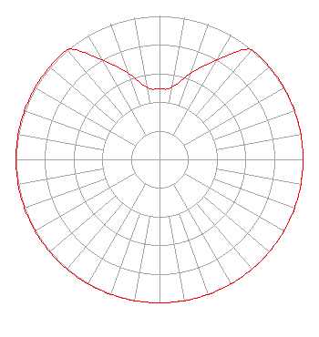 | ||||||||||||||||||
| Azimuth | Ratio | Azimuth | Ratio | Azimuth | Ratio | Azimuth | Ratio | ||||||||||||
| 0 | 0.490 | 10 | 0.510 | 20 | 0.640 | 30 | 0.800 | ||||||||||||
| 40 | 1.000 | 50 | 1.000 | 60 | 1.000 | 70 | 1.000 | ||||||||||||
| 80 | 1.000 | 90 | 1.000 | 100 | 1.000 | 110 | 1.000 | ||||||||||||
| 120 | 1.000 | 130 | 1.000 | 140 | 1.000 | 150 | 1.000 | ||||||||||||
| 160 | 1.000 | 170 | 1.000 | 180 | 1.000 | 190 | 1.000 | ||||||||||||
| 200 | 1.000 | 210 | 1.000 | 220 | 1.000 | 230 | 1.000 | ||||||||||||
| 240 | 1.000 | 250 | 1.000 | 260 | 1.000 | 270 | 1.000 | ||||||||||||
| 280 | 1.000 | 290 | 1.000 | 300 | 1.000 | 310 | 1.000 | ||||||||||||
| 320 | 1.000 | 330 | 0.800 | 340 | 0.640 | 350 | 0.510 | ||||||||||||
Structure Registration Number 1040901 Structure Type: TOWER Registered To: PINES BROADCASTING INC DBA = KWRF RADIO Structure Address: On Hwy 15 One Mi N Warren, AR County Name: Bradley County ASR Issued: 12/28/2010 Date Built: 06/01/1976 Site Elevation: 61 m (200 ft.) Structure Height: 1 m (3 ft.) Height Overall: 77.1 m (253 ft.) Overall Height AMSL: 138.1 m (453 ft.) FAA Determination: 12/07/2010 FAA Study #: 2010-ASW-6377-OE Paint & Light FAA Chapters: 1, 3, 11, 21 PRIOR STUDY 1989-ASW-1450-OE 33-38-08.3 N 92-03-56.2 W (NAD 83) 33-38-07.9 N 92-03-55.7 W (Converted to NAD 27) |
1255 North Myrtle Street Warren, AR 71671 Phone: 870-226-2653 | Date: 03/15/2011 Application Certifier PINES BROADCASTING, INC. 1255 North Myrtle Street Warren, AR 71671 Applicant JIMMY SLEDGE 1255 North Myrtle Street Warren, AR 71671 PRESIDENT JOHN F. GARZIGLIA, ESQ. Womble Carlyle Sandridge & Rice, Pllc 1401 Eye Street, Nw Suite 700 Washington, DC 20005 | |||||||||||||||||