
FCCInfo.com
A Service of Cavell, Mertz & Associates, Inc.
(855) FCC-INFO
|
|
|
|  |
|
|||||||||||||||
|
|
WUON Channel: 207A 89.3 MHz Morris, Illinois Service: FM - A full-service FM station or application. Facility ID: 176405 Fac. Service: FM Status: License Application Accepted: 04/15/2014 Application Granted: 05/02/2014 File Number: BLED-20140415AAU License Expires: 00/00/0000 Prefix Type: This is a license for a noncommercial educational FM station Application Type: License To Cover FCC Website Links: LMS Facility Details This Application CDBS Application Other WUON Applications Other WUON Applications in CDBS Including Superseded Applications Mailing Address Correspondence for WUON Correspondence related to application BLED-20140415AAU Service Contour - Open Street Map or USGS Map (60 dBu) Service Contour - KML / Google Earth (60 dBu) Public Inspection Files Facility Type: NON-COMMERCIAL EDUC. FM Class: A, A Zone I; I-A; or II station; with 0.1kW-6kW ERP and a class contour distance <=28km Site Location: 41-21-17.1 N 88-29-55.3 W (NAD 83) Site Location: 41-21-17.0 N 88-29-55.0 W (Converted to NAD 27) Effective Radiated Power: 1.35 kW Transmitter Output Power: 0.805 kW Antenna Center HAAT: 73 m (240 ft.) Antenna Center AMSL: 250.6 m (822 ft.) Antenna Center HAG: 79.9 m (262 ft.) Calculated Site Elevation: 170.7 m. (560 ft.) Height Overall*: 152 m (499 ft.) (* As Filed In This Application, may differ from ASR Data, Below.) Directional Antenna Antenna Make/Model: Electronics Research Inc. LP-2E-DA, two sections Antenna ID: 114049 Polarization:
| ||||||||||||||||||
| Antenna Data for Antenna Id: 114049 WUON FM File: BLED-20140415AAU Electronics Research Inc. - LP-2E-DA, two sections Service: FM | 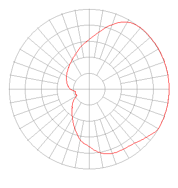 | ||||||||||||||||||
| Azimuth | Ratio | Azimuth | Ratio | Azimuth | Ratio | Azimuth | Ratio | ||||||||||||
| 0 | 0.616 | 10 | 0.721 | 20 | 0.857 | 30 | 0.962 | ||||||||||||
| 40 | 1.000 | 45 | 1.000 | 50 | 1.000 | 60 | 1.000 | ||||||||||||
| 70 | 1.000 | 80 | 1.000 | 90 | 1.000 | 100 | 1.000 | ||||||||||||
| 110 | 1.000 | 120 | 1.000 | 130 | 0.940 | 135 | 0.912 | ||||||||||||
| 140 | 0.884 | 150 | 0.867 | 160 | 0.857 | 170 | 0.810 | ||||||||||||
| 180 | 0.721 | 190 | 0.643 | 200 | 0.523 | 210 | 0.416 | ||||||||||||
| 220 | 0.330 | 225 | 0.296 | 230 | 0.262 | 240 | 0.178 | ||||||||||||
| 250 | 0.178 | 260 | 0.178 | 270 | 0.236 | 280 | 0.271 | ||||||||||||
| 290 | 0.297 | 300 | 0.324 | 310 | 0.349 | 315 | 0.366 | ||||||||||||
| 320 | 0.383 | 330 | 0.420 | 340 | 0.471 | 350 | 0.542 | ||||||||||||
Structure Registration Number 1008075 Structure Type: TOWER Registered To: University of Northwestern-St. Paul Structure Address: 91m S Of Stockdale Rd 800m W Of Saratoga Rd Morris, IL County Name: Grundy County ASR Issued: 11/04/2019 Date Built: 01/01/1989 Site Elevation: 170.7 m (560 ft.) Structure Height: 140 m (459 ft.) Height Overall: 152 m (499 ft.) Overall Height AMSL: 322.7 m (1059 ft.) FAA Determination: 02/06/1990 FAA Study #: 89-AGL-3-OE FAA Circular #: 70/7460-1G Paint & Light FAA Chapters: 3, 4, 5, 9 41-21-17.0 N 88-29-55.0 W (NAD 83) 41-21-16.9 N 88-29-54.7 W (Converted to NAD 27) |
108 Boeykens Pl Normal, IL 61761 Phone: 309-242-4244 Not-for-Profit | Date: 04/15/2014 Application Certifier OLIVET NAZARENE UNIVERSITY One University Avenue Bourbonnais, IL 60914 Applicant CARY S. TEPPER 4900 Auburn Avenue Suite 100 Bethesda, MD 20814-2632 COMMUNICATIONS COUNSEL CARY S. TEPPER, ESQ. Booth, Freret, Imlay & Tepper, P.c. | |||||||||||||||||