
FCCInfo.com
A Service of Cavell, Mertz & Associates, Inc.
(855) FCC-INFO
|
|
W241BB from 10/10/2007 W241BB from 09/01/2004 |
|
|
||||||||||||||||
|
|
W241BB Channel: 241D 96.1 MHz Wilkes-barre, Pennsylvania Service: FX - A translator or application for a translator. Facility ID: 143060 Fac. Service: FX Programming Delivery Method: Unspecified Status: License Application Accepted: 11/01/2007 Application Granted: 11/21/2007 File Number: BLFT-20071101AAD License Expires: 00/00/0000 Prefix Type: This is a license for a translator Application Type: License To Cover FCC Website Links: LMS Facility Details This Application CDBS Application Other W241BB Applications Other W241BB Applications in CDBS Including Superseded Applications Mailing Address Correspondence for W241BB Correspondence related to application BLFT-20071101AAD Service Contour - Open Street Map or USGS Map (60 dBu) Service Contour - KML / Google Earth (60 dBu) Class: D, A Noncommercial educational operating with no more than 10W Site Location: 41-11-11.3 N 75-51-31.7 W (NAD 83) Site Location: 41-11-11.0 N 75-51-33.0 W (Converted to NAD 27) Effective Radiated Power: 0 kW Horiz. ; 0.006 kW Vert. Transmitter Output Power: 0.002 kW Antenna Center HAAT: 0 m Horiz.; 251.8 m Vert. Antenna Center AMSL: 0 m Horiz.; 648 m Vert. Antenna Center HAG: 0 m Horiz.; 38 m Vert. Site Elevation: 610 m. (2001 ft.) Height Overall*: 87 m (285 ft.) (* As Filed In This Application, may differ from ASR Data, Below.) Directional Antenna Antenna Make/Model: None Antenna ID: 13383 Polarization:
| ||||||||||||||||||
| Antenna Data for Antenna Id: 13383 W241BB FX File: BLFT-20071101AAD None - Service: FX Pattern and Field Values Include a 335° Clockwise Rotation | 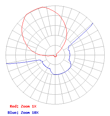 | ||||||||||||||||||
| Azimuth | Ratio | Azimuth | Ratio | Azimuth | Ratio | Azimuth | Ratio | ||||||||||||
| 5 | 0.817 | 15 | 0.690 | 20 | 0.618 | 25 | 0.543 | ||||||||||||
| 35 | 0.390 | 45 | 0.190 | 55 | 0.050 | 65 | 0.030 | ||||||||||||
| 75 | 0.030 | 85 | 0.030 | 95 | 0.030 | 105 | 0.030 | ||||||||||||
| 110 | 0.030 | 115 | 0.034 | 125 | 0.039 | 135 | 0.040 | ||||||||||||
| 145 | 0.040 | 155 | 0.040 | 165 | 0.040 | 175 | 0.040 | ||||||||||||
| 185 | 0.039 | 195 | 0.034 | 200 | 0.030 | 205 | 0.030 | ||||||||||||
| 215 | 0.030 | 225 | 0.030 | 235 | 0.030 | 245 | 0.030 | ||||||||||||
| 255 | 0.050 | 265 | 0.190 | 275 | 0.390 | 285 | 0.544 | ||||||||||||
| 290 | 0.618 | 295 | 0.690 | 305 | 0.818 | 315 | 0.917 | ||||||||||||
| 325 | 1.000 | 330 | 1.000 | 335 | 1.000 | 340 | 1.000 | ||||||||||||
| 345 | 1.000 | 355 | 0.916 | ||||||||||||||||
Structure Registration Number 1201213 Structure Type: TOWER Registered To: The Scranton Times, L.P. Structure Address: Penobscot Mountain, 1000 Sterling Street Mountain Top, PA County Name: Luzerne County ASR Issued: 03/24/2011 Date Built: 12/22/2000 Site Elevation: 609.6 m (2000 ft.) Structure Height: 85.3 m (280 ft.) Height Overall: 86.9 m (285 ft.) Overall Height AMSL: 696.5 m (2285 ft.) FAA Determination: 07/19/1999 FAA Study #: 98-AEA-3690-OE FAA Circular #: 70/7460-1J Paint & Light FAA Chapters: 4, 8, 13 Removed expiration date from determination. Scenario 1./jjs/case#635066 41-11-11.3 N 75-51-31.7 W (NAD 83) 41-11-11.0 N 75-51-33.0 W (Converted to NAD 27) |
149 Penn Avenue Scranton, PA 18503 Phone: 570-348-9100 Limited Partnership | Date: 11/01/2007 Application Certifier THE SCRANTON TIMES, L.P. 149 Penn Avenue Scranton, PA 18503 Applicant KEVIN M. FITZGERALD P.o. Box 20155 Scranton, PA 18502 DIRECTOR OF ENGINEERING KENNETH E. SATTEN Wilkinson Barker Knauer, Llp 2300 N Street, Nw, Ste. 700 Washington, DC 20037-1128 | |||||||||||||||||