
FCCInfo.com
A Service of Cavell, Mertz & Associates, Inc.
(855) FCC-INFO
|
|
WDVT from 01/14/1994 WDVT from 04/15/1991 WDVT from 09/24/1990 |
|  |
|
||||||||||||||||||
|
|
WDVT Channel: 233A 94.5 MHz Rutland, Vermont Service: FM - A full-service FM station or application. Facility ID: 14719 Fac. Service: FM Status: License 73.215 Station Application Accepted: 02/17/2010 Application Granted: 03/08/2010 File Number: BLH-20100217AAS License Expires: 00/00/0000 Prefix Type: This is a license for a commercial FM station Application Type: License To Cover FCC Website Links: LMS Facility Details This Application CDBS Application Other WDVT Applications Other WDVT Applications in CDBS Including Superseded Applications Mailing Address Correspondence for WDVT Correspondence related to application BLH-20100217AAS Service Contour - Open Street Map or USGS Map (60 dBu) Service Contour - KML / Google Earth (60 dBu) Public Inspection Files Facility Type: FM STATION Class: A, A Zone I; I-A; or II station; with 0.1kW-6kW ERP and a class contour distance <=28km Site Location: 43-34-04.2 N 73-00-30.4 W (NAD 83) Site Location: 43-34-04.0 N 73-00-32.0 W (Converted to NAD 27) Effective Radiated Power: 6 kW Transmitter Output Power: 5.1 kW Antenna Center HAAT: 98 m (322 ft.) Antenna Center AMSL: 450.4 m (1478 ft.) Antenna Center HAG: 57.2 m (188 ft.) Calculated Site Elevation: 393.2 m. (1290 ft.) Height Overall*: 59.8 m (196 ft.) (* As Filed In This Application, may differ from ASR Data, Below.) Directional Antenna Antenna Make/Model: Shivley 6810-2R-SS(0.5)-DA Antenna ID: 91689 Polarization: | |||||||||||||||||||||
| Antenna Data for Antenna Id: 91689 WDVT FM File: BLH-20100217AAS Shivley - 6810-2R-SS(0.5)-DA Service: FM | 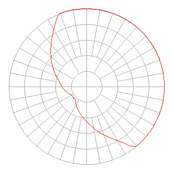 | |||||||||||||||||||||
| Azimuth | Ratio | Azimuth | Ratio | Azimuth | Ratio | Azimuth | Ratio | |||||||||||||||
| 0 | 1.000 | 10 | 1.000 | 20 | 1.000 | 30 | 1.000 | |||||||||||||||
| 40 | 1.000 | 50 | 1.000 | 60 | 1.000 | 70 | 1.000 | |||||||||||||||
| 80 | 1.000 | 90 | 1.000 | 100 | 1.000 | 110 | 1.000 | |||||||||||||||
| 120 | 1.000 | 130 | 1.000 | 140 | 1.000 | 150 | 0.803 | |||||||||||||||
| 160 | 0.660 | 170 | 0.543 | 180 | 0.446 | 190 | 0.375 | |||||||||||||||
| 200 | 0.316 | 210 | 0.266 | 220 | 0.223 | 230 | 0.223 | |||||||||||||||
| 240 | 0.223 | 250 | 0.251 | 260 | 0.281 | 270 | 0.316 | |||||||||||||||
| 280 | 0.354 | 290 | 0.421 | 300 | 0.501 | 310 | 0.595 | |||||||||||||||
| 320 | 0.707 | 330 | 0.841 | 340 | 1.000 | 350 | 1.000 | |||||||||||||||
Structure Registration Number 1040762 Structure Type: Registered To: Gray Media Group, Inc. Structure Address: Approximately 3.5 Miles (5.6 Km) South Southwest Of Rutland, VT County Name: Rutland County ASR Issued: 09/09/2020 Date Built: 06/17/2016 Site Elevation: 393.2 m (1290 ft.) Structure Height: 55.5 m (182 ft.) Height Overall: 59.8 m (196 ft.) Overall Height AMSL: 453 m (1486 ft.) FAA Determination: 08/10/2007 FAA Study #: 2007-ANE-1325-OE Paint & Light FAA Chapters: NONE Removed expiration date from determination. Scenario 1./jjs/case#635066 43-34-04.0 N 73-00-30.0 W (NAD 83) 43-34-03.8 N 73-00-31.6 W (Converted to NAD 27) |
6 Johnson Rd Latham, NY 12110-5641 Phone: 518-786-6600 | Date: 02/17/2010 Application Certifier 6 JOHNSON ROAD LICENSES, INC. 6 Johnson Road Latham, NY 12110 Applicant BERTRAM GOLDMAN 5948 Charlestown Dr. Dallas, TX 75230 TECHNICAL CONSULTANT LAWRENCE M. MILLER Schwartz, Woods & Miller | ||||||||||||||||||||
| ||||||||||||||||||||||