
FCCInfo.com
A Service of Cavell, Mertz & Associates, Inc.
(855) FCC-INFO
|
|
K253AY from 03/22/2004 |
|
|
||||||||||||||||
|
|
K253AY Channel: 253D 98.5 MHz Norman, Oklahoma Service: FX - A translator or application for a translator. Facility ID: 148125 Fac. Service: FX Programming Delivery Method: Unspecified Status: License Application Accepted: 03/27/2014 Application Granted: 04/29/2014 File Number: BLFT-20140327BGZ License Expires: 00/00/0000 Prefix Type: This is a license for a translator Application Type: License To Cover FCC Website Links: LMS Facility Details This Application CDBS Application Other K253AY Applications Other K253AY Applications in CDBS Including Superseded Applications Mailing Address Correspondence for K253AY Correspondence related to application BLFT-20140327BGZ Service Contour - Open Street Map or USGS Map (60 dBu) Service Contour - KML / Google Earth (60 dBu) Class: D, A Noncommercial educational operating with no more than 10W Site Location: 35-13-04.2 N 97-24-38.1 W (NAD 83) Site Location: 35-13-04.0 N 97-24-37.0 W (Converted to NAD 27) Effective Radiated Power: 0.25 kW Transmitter Output Power: 0.386 kW Antenna Center HAAT: 0 m Antenna Center AMSL: 419 m (1375 ft.) Antenna Center HAG: 53 m (174 ft.) Site Elevation: 366 m. (1201 ft.) Height Overall*: 56 m (184 ft.) (* As Filed In This Application, may differ from ASR Data, Below.) Directional Antenna Antenna Make/Model: None Antenna ID: 117559 Polarization:
| ||||||||||||||||||
| Antenna Data for Antenna Id: 117559 K253AY FX File: BLFT-20140327BGZ None - Service: FX Pattern and Field Values Include a 180° Clockwise Rotation | 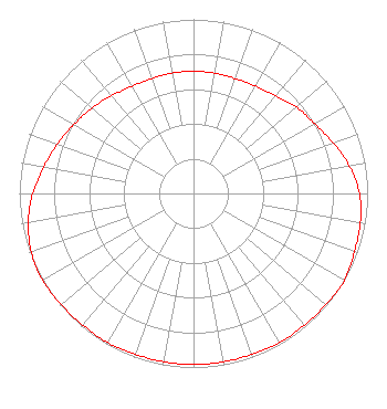 | ||||||||||||||||||
| Azimuth | Ratio | Azimuth | Ratio | Azimuth | Ratio | Azimuth | Ratio | ||||||||||||
| 0 | 0.702 | 10 | 0.702 | 20 | 0.702 | 30 | 0.712 | ||||||||||||
| 40 | 0.732 | 50 | 0.772 | 60 | 0.802 | 70 | 0.853 | ||||||||||||
| 80 | 0.909 | 90 | 0.953 | 100 | 0.973 | 110 | 0.983 | ||||||||||||
| 120 | 1.000 | 130 | 0.992 | 140 | 0.988 | 150 | 0.988 | ||||||||||||
| 160 | 0.983 | 170 | 0.983 | 180 | 0.983 | 190 | 0.983 | ||||||||||||
| 200 | 0.983 | 210 | 0.988 | 220 | 0.988 | 230 | 0.992 | ||||||||||||
| 240 | 1.000 | 250 | 0.991 | 260 | 0.963 | 270 | 0.923 | ||||||||||||
| 280 | 0.873 | 290 | 0.832 | 300 | 0.792 | 310 | 0.762 | ||||||||||||
| 320 | 0.732 | 330 | 0.710 | 340 | 0.702 | 350 | 0.702 | ||||||||||||
Structure Registration Number 1012834 Structure Type: TOWER Registered To: Metro Radio Group, LLC Structure Address: 2020 E Alameda Norman, OK County Name: Cleveland County ASR Issued: 01/27/2014 Date Built: 01/01/1977 Site Elevation: 365.7 m (1200 ft.) Structure Height: 55.1 m (181 ft.) Height Overall: 56 m (184 ft.) Overall Height AMSL: 421.7 m (1384 ft.) FAA Determination: 06/24/1977 FAA Study #: 77-ASW-865-OE Paint & Light FAA Chapters: NONE 35-13-04.0 N 97-24-38.0 W (NAD 83) 35-13-03.8 N 97-24-36.9 W (Converted to NAD 27) |
P.o. Box 14 Ponca City, OK 74602-0014 Phone: 800-324-8488 | Date: 03/27/2014 Application Certifier THE LOVE STATION, INC. P. O. Box 14 Ponca City, OK 74602-0014 Applicant GENE WISNIEWSKI 160 Gooding Street West Suite A Twin Falls, ID 83301 CONSULTING ENGINEER THE LOVE STATION, INC. The Love Station, Inc. P. O. Box 14 Ponca City, OK 74602-0014 | |||||||||||||||||