
FCCInfo.com
A Service of Cavell, Mertz & Associates, Inc.
(855) FCC-INFO
|
|
K208FM from 09/16/2010 K208FM from 12/04/1996 |
|
|
||||||||||||||||
|
|
K208FM Channel: 208D 89.5 MHz Pierre, South Dakota Service: FX - A translator or application for a translator. Facility ID: 82017 Fac. Service: FX Programming Delivery Method: Unspecified Status: License Application Accepted: 01/07/2011 Application Granted: 02/08/2011 File Number: BLFT-20110107ACG License Expires: 00/00/0000 Prefix Type: This is a license for a translator Application Type: License To Cover FCC Website Links: LMS Facility Details This Application CDBS Application Other K208FM Applications Other K208FM Applications in CDBS Including Superseded Applications Mailing Address Correspondence for K208FM Correspondence related to application BLFT-20110107ACG Service Contour - Open Street Map or USGS Map (60 dBu) Service Contour - KML / Google Earth (60 dBu) Class: D, A Noncommercial educational operating with no more than 10W Site Location: 44-25-12.9 N 100-20-49.4 W (NAD 83) Site Location: 44-25-13.0 N 100-20-47.9 W (Converted to NAD 27) Effective Radiated Power: 0 kW Horiz. ; 0.092 kW Vert. Transmitter Output Power: 0.095 kW Antenna Center HAAT: 0 m Horiz.; 118.3 m Vert. Antenna Center AMSL: 0 m Horiz.; 628 m Vert. Antenna Center HAG: 0 m Horiz.; 46 m Vert. Site Elevation: 582 m. (1909 ft.) Height Overall*: 61 m (200 ft.) (* As Filed In This Application, may differ from ASR Data, Below.) Directional Antenna Antenna Make/Model: None Antenna ID: 101897 Polarization:
| ||||||||||||||||||
| Antenna Data for Antenna Id: 101897 K208FM FX File: BLFT-20110107ACG None - Service: FX | 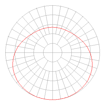 | ||||||||||||||||||
| Azimuth | Ratio | Azimuth | Ratio | Azimuth | Ratio | Azimuth | Ratio | ||||||||||||
| 0 | 0.534 | 10 | 0.535 | 20 | 0.540 | 30 | 0.549 | ||||||||||||
| 40 | 0.566 | 50 | 0.592 | 60 | 0.630 | 70 | 0.679 | ||||||||||||
| 80 | 0.735 | 90 | 0.792 | 100 | 0.845 | 110 | 0.892 | ||||||||||||
| 120 | 0.929 | 130 | 0.956 | 140 | 0.975 | 150 | 0.987 | ||||||||||||
| 160 | 0.995 | 170 | 0.999 | 180 | 1.000 | 190 | 0.999 | ||||||||||||
| 200 | 0.995 | 210 | 0.987 | 220 | 0.975 | 230 | 0.956 | ||||||||||||
| 240 | 0.929 | 250 | 0.892 | 260 | 0.845 | 270 | 0.792 | ||||||||||||
| 280 | 0.735 | 290 | 0.679 | 300 | 0.630 | 310 | 0.592 | ||||||||||||
| 320 | 0.566 | 330 | 0.549 | 340 | 0.540 | 350 | 0.535 | ||||||||||||
Structure Registration Number 1202683 Structure Type: TOWER Registered To: Pierre Radio Paging & Telephone Inc Structure Address: Pierre, South Dakota Pierre, SD County Name: Hughes County ASR Issued: 09/13/1999 Date Built: 10/17/1996 Site Elevation: 582.1 m (1910 ft.) Structure Height: 60.6 m (199 ft.) Height Overall: 60.6 m (199 ft.) Overall Height AMSL: 642.7 m (2109 ft.) FAA Determination: 04/18/1996 FAA Study #: 96-AGL-0520-OE Paint & Light FAA Chapters: NONE 44-25-12.9 N 100-20-49.4 W (NAD 83) 44-25-13.0 N 100-20-47.9 W (Converted to NAD 27) |
820 N Lasalle St Chicago, IL 60610-3214 Phone: 312-329-4438 | Date: 01/07/2011 Application Certifier THE MOODY BIBLE INSTITUTE OF CHICAGO 820 North Lasalle Boulevard Chicago, IL 60610-3284 Applicant JEFFREY D SOUTHMAYD Southmayd & Miller 4 Ocean Ridge Boulevard South Palm Coast, FL 32137 ATTORNEY JEFFREY D. SOUTHMAYD Southmayd & Miller 4 Ocean Ridge Boulevard South Palm Coast, FL 32137 | |||||||||||||||||