
FCCInfo.com
A Service of Cavell, Mertz & Associates, Inc.
(855) FCC-INFO
|
|
|
|  |
|
|||||||||||||||
|
|
WTCY Channel: 202C3 88.3 MHz Greilickville, Michigan Service: FM - A full-service FM station or application. Facility ID: 171772 Fac. Service: FM Status: License Application Accepted: 12/21/2011 Application Granted: 01/18/2012 File Number: BLED-20111221ADX License Expires: 00/00/0000 Prefix Type: This is a license for a noncommercial educational FM station Application Type: Amendment FCC Website Links: LMS Facility Details This Application CDBS Application Other WTCY Applications Other WTCY Applications in CDBS Including Superseded Applications Mailing Address Correspondence for WTCY Correspondence related to application BLED-20111221ADX Service Contour - Open Street Map or USGS Map (60 dBu) Service Contour - KML / Google Earth (60 dBu) Public Inspection Files Facility Type: NON-COMMERCIAL EDUC. FM Class: C3, A Zone II station; with 6kW-25kW ERP and a class contour distance 28km-39km Site Location: 44-57-59.0 N 85-46-28.3 W (NAD 83) Site Location: 44-57-59.0 N 85-46-28.0 W (Converted to NAD 27) Effective Radiated Power: 0 kW Horiz. ; 4.4 kW Vert. Transmitter Output Power: 1.087 kW Antenna Center HAAT: 0 m Horiz.; 207 m Vert. Antenna Center AMSL: 0 m Horiz.; 409.7 m Vert. Antenna Center HAG: 0 m Horiz.; 126.5 m Vert. Calculated Site Elevation: m. Height Overall*: 146.3 m (480 ft.) (* As Filed In This Application, may differ from ASR Data, Below.) Directional Antenna Antenna Make/Model: Shivley 6018V-1/1 Antenna ID: 107168 Polarization:
| ||||||||||||||||||
| Antenna Data for Antenna Id: 107168 WTCY FM File: BLED-20111221ADX Shivley - 6018V-1/1 Service: FM Pattern and Field Values Include a 150° Clockwise Rotation | 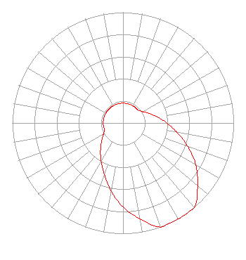 | ||||||||||||||||||
| Azimuth | Ratio | Azimuth | Ratio | Azimuth | Ratio | Azimuth | Ratio | ||||||||||||
| 0 | 0.179 | 10 | 0.179 | 20 | 0.179 | 30 | 0.179 | ||||||||||||
| 40 | 0.179 | 50 | 0.179 | 60 | 0.205 | 70 | 0.251 | ||||||||||||
| 80 | 0.316 | 90 | 0.396 | 100 | 0.495 | 110 | 0.623 | ||||||||||||
| 120 | 0.760 | 130 | 0.880 | 140 | 1.000 | 150 | 1.000 | ||||||||||||
| 160 | 1.000 | 170 | 0.880 | 180 | 0.760 | 190 | 0.623 | ||||||||||||
| 200 | 0.495 | 210 | 0.396 | 220 | 0.316 | 230 | 0.251 | ||||||||||||
| 240 | 0.205 | 250 | 0.179 | 260 | 0.179 | 270 | 0.179 | ||||||||||||
| 280 | 0.179 | 290 | 0.179 | 300 | 0.179 | 310 | 0.179 | ||||||||||||
| 320 | 0.179 | 330 | 0.179 | 340 | 0.179 | 350 | 0.179 | ||||||||||||
Structure Registration Number 1064784 [ASR Heights Differ from WTCY Application] Structure Type: TOWER Registered To: LEELANAU, COUNTY OF Structure Address: 1.5 Km S Of M22 & Shomberg Rd. Leland, MI County Name: Leelanau County ASR Issued: 09/30/2009 Date Built: 09/06/2009 Site Elevation: 283.2 m (929 ft.) Structure Height: 140 m (459 ft.) Height Overall: 146.3 m (480 ft.) Overall Height AMSL: 429.5 m (1409 ft.) FAA Determination: 07/07/2009 FAA Study #: 2009-AGL-2928-OE Paint & Light FAA Chapters: A2, H PRIOR STUDY 1996-AGL-795-OE 44-57-59.1 N 85-46-28.2 W (NAD 83) 44-57-59.1 N 85-46-27.9 W (Converted to NAD 27) |
680 Barclay Boulevard Lincolnshire, IL 60069 Phone: 877-291-0123 | Date: 12/21/2011 Application Certifier BARAGA BROADCASTING, INC. Post Office Box 1109 Indian River, MI 49749 Applicant DENNIS J. KELLY Law Office Of Dennis J. Kelly ROBERT WALKER Post Office Box 28961 Austin, TX 78755 ATTORNEY/CONSULTANT | |||||||||||||||||