
FCCInfo.com
A Service of Cavell, Mertz & Associates, Inc.
(855) FCC-INFO
|
|
W225CM from 03/10/2004 |
|
|
||||||||||||||||
|
|
W225CM Channel: 225D 92.9 MHz Delaware, Ohio Service: FX - A translator or application for a translator. Facility ID: 142214 Fac. Service: FX Programming Delivery Method: Unspecified Status: License Application Accepted: 06/21/2016 Application Granted: 07/11/2016 File Number: BLFT-20160621AAE License Expires: 00/00/0000 Prefix Type: This is a license for a translator Application Type: License To Cover FCC Website Links: LMS Facility Details This Application CDBS Application Other W225CM Applications Other W225CM Applications in CDBS Including Superseded Applications Mailing Address Correspondence for W225CM Correspondence related to application BLFT-20160621AAE Service Contour - Open Street Map or USGS Map (60 dBu) Service Contour - KML / Google Earth (60 dBu) Class: D, A Noncommercial educational operating with no more than 10W Site Location: 40-17-57.0 N 83-02-45.0 W (NAD 83) Site Location: 40-17-56.8 N 83-02-45.3 W (Converted to NAD 27) Effective Radiated Power: 0.25 kW Transmitter Output Power: 0.045 kW Antenna Center HAAT: 0 m Antenna Center AMSL: 362 m (1188 ft.) Antenna Center HAG: 76 m (249 ft.) Site Elevation: 286 m. (938 ft.) Height Overall*: 83 m (272 ft.) (* As Filed In This Application, may differ from ASR Data, Below.) Directional Antenna Antenna Make/Model: None Antenna ID: 124513 Polarization:
| ||||||||||||||||||
| Antenna Data for Antenna Id: 124513 W225CM FX File: BLFT-20160621AAE None - Service: FX | 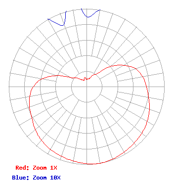 | ||||||||||||||||||
| Azimuth | Ratio | Azimuth | Ratio | Azimuth | Ratio | Azimuth | Ratio | ||||||||||||
| 0 | 0.090 | 10 | 0.100 | 20 | 0.110 | 30 | 0.170 | ||||||||||||
| 40 | 0.220 | 50 | 0.400 | 60 | 0.545 | 70 | 0.670 | ||||||||||||
| 80 | 0.730 | 90 | 0.770 | 100 | 0.810 | 110 | 0.860 | ||||||||||||
| 120 | 0.900 | 130 | 0.930 | 140 | 0.950 | 150 | 0.970 | ||||||||||||
| 160 | 0.990 | 170 | 1.000 | 180 | 0.990 | 190 | 0.970 | ||||||||||||
| 200 | 0.950 | 210 | 0.930 | 220 | 0.900 | 230 | 0.860 | ||||||||||||
| 240 | 0.810 | 250 | 0.780 | 260 | 0.740 | 270 | 0.680 | ||||||||||||
| 280 | 0.578 | 290 | 0.410 | 300 | 0.230 | 310 | 0.176 | ||||||||||||
| 320 | 0.120 | 330 | 0.100 | 340 | 0.085 | 350 | 0.120 | ||||||||||||
Structure Registration Number 1009841 Structure Type: TOWER Registered To: RADIO DELAWARE INC Structure Address: 501 Bowtown Rd Delaware, OH County Name: Delaware County ASR Issued: 12/09/1996 Date Built: 01/01/1990 Site Elevation: 286 m (938 ft.) Structure Height: 82.3 m (270 ft.) Height Overall: 82.9 m (272 ft.) Overall Height AMSL: 368.9 m (1210 ft.) FAA Determination: 06/21/1990 FAA Study #: 90-AGL-211-OE FAA Circular #: 70/7460-1G Paint & Light FAA Chapters: 3, 4, 5, 9 40-17-57.0 N 83-02-45.0 W (NAD 83) 40-17-56.8 N 83-02-45.3 W (Converted to NAD 27) |
4001 Curve Road Delaware, OH 43015 Phone: 614-832-9156 | Date: 06/21/2016 Application Certifier DELMAR COMMUNICATIONS, INC. 4001 Curve Road Delaware, OH 43015 Applicant CLARENCE M. BEVERAGE Communications Technologies, Inc. P.o. Box 1130 Marlton, NJ 08053 BROADCAST ENGINEERING CONSULTANT CARY S. TEPPER Tepper Law Firm, Llc 4900 Auburn Avenue Suite 100 Bethesda, MD 20814-2632 | |||||||||||||||||