
FCCInfo.com
A Service of Cavell, Mertz & Associates, Inc.
(855) FCC-INFO
|
|
W217CD from 12/18/1992 W217CD from 12/20/1990 |
|
|
||||||||||||||||
|
|
W217CD Channel: 217D 91.3 MHz Dyersburg, Tennessee Service: FX - A translator or application for a translator. Facility ID: 65970 Fac. Service: FX Programming Delivery Method: Unspecified Status: License Application Accepted: 04/11/2017 Application Granted: 04/19/2017 File Number: BLFT-20170411ABR License Expires: 00/00/0000 Prefix Type: This is a license for a translator Application Type: License To Cover FCC Website Links: LMS Facility Details This Application CDBS Application Other W217CD Applications Other W217CD Applications in CDBS Including Superseded Applications Mailing Address Correspondence for W217CD Correspondence related to application BLFT-20170411ABR Service Contour - Open Street Map or USGS Map (60 dBu) Service Contour - KML / Google Earth (60 dBu) Class: D, A Noncommercial educational operating with no more than 10W Site Location: 36-03-28.0 N 89-26-19.0 W (NAD 83) Site Location: 36-03-27.7 N 89-26-18.7 W (Converted to NAD 27) Effective Radiated Power: 0.027 kW Horiz. ; 0 kW Vert. Transmitter Output Power: 0.05 kW Antenna Center HAAT: 0 m Antenna Center AMSL: 180 m Horiz.; 0 m Vert. Antenna Center HAG: 70 m Horiz.; 0 m Vert. Site Elevation: 110 m. (361 ft.) Height Overall*: 152 m (499 ft.) (* As Filed In This Application, may differ from ASR Data, Below.) Directional Antenna Antenna Make/Model: None Antenna ID: 16173 Polarization:
| ||||||||||||||||||
| Antenna Data for Antenna Id: 16173 W217CD FX File: BLFT-20170411ABR None - Service: FX Pattern and Field Values Include a 115° Clockwise Rotation | 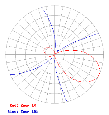 | ||||||||||||||||||
| Azimuth | Ratio | Azimuth | Ratio | Azimuth | Ratio | Azimuth | Ratio | ||||||||||||
| 5 | 0.023 | 15 | 0.010 | 25 | 0.010 | 35 | 0.010 | ||||||||||||
| 45 | 0.010 | 55 | 0.030 | 65 | 0.108 | 75 | 0.320 | ||||||||||||
| 85 | 0.585 | 95 | 0.792 | 105 | 0.937 | 115 | 1.000 | ||||||||||||
| 125 | 0.937 | 135 | 0.792 | 145 | 0.585 | 155 | 0.320 | ||||||||||||
| 165 | 0.108 | 175 | 0.030 | 185 | 0.010 | 195 | 0.010 | ||||||||||||
| 205 | 0.010 | 215 | 0.010 | 225 | 0.023 | 235 | 0.055 | ||||||||||||
| 245 | 0.097 | 255 | 0.133 | 265 | 0.162 | 275 | 0.192 | ||||||||||||
| 285 | 0.222 | 295 | 0.233 | 305 | 0.222 | 315 | 0.192 | ||||||||||||
| 325 | 0.162 | 335 | 0.133 | 345 | 0.097 | 355 | 0.055 | ||||||||||||
Structure Registration Number 1059207 Structure Type: TOWER Registered To: OMNI TOWERS Structure Address: 1755 Resthome Rd Dyersburg, TN County Name: Dyer County ASR Issued: 10/19/2004 Date Built: 12/10/1998 Site Elevation: 109.7 m (360 ft.) Structure Height: 152.4 m (500 ft.) Height Overall: 152.4 m (500 ft.) Overall Height AMSL: 262.1 m (860 ft.) FAA Determination: 12/10/1998 FAA Study #: 98-ASO-7001-OE FAA Circular #: 70/7460-1J Paint & Light FAA Chapters: 4, 6, 13 36-03-28.0 N 89-26-19.0 W (NAD 83) 36-03-27.7 N 89-26-18.7 W (Converted to NAD 27) |
820 N Lasalle St Chicago, IL 60610-3214 Phone: 312-329-4438 | Date: 04/11/2017 Application Certifier THE MOODY BIBLE INSTITUTE OF CHICAGO 820 North Lasalle Boulevard Chicago, IL 60610-3284 Applicant JEFFREY D SOUTHMAYD Southmayd & Miller 4 Ocean Ridge Boulevard South Palm Coast, FL 32137 ATTORNEY JEFFREY D. SOUTHMAYD Southmayd & Miller 4 Ocean Ridge Boulevard South Palm Coast, FL 32137 | |||||||||||||||||