
FCCInfo.com
A Service of Cavell, Mertz & Associates, Inc.
(855) FCC-INFO
|
|
KIAD from 09/08/1998 |
|  |
|
|||||||||||||||
|
|
KIAD Channel: 203A 88.5 MHz Dubuque, Iowa Service: FM - A full-service FM station or application. Facility ID: 91585 Fac. Service: FM Status: License Application Accepted: 04/24/2006 Application Granted: 09/21/2006 File Number: BLED-20060424ADO License Expires: 00/00/0000 Prefix Type: This is a license for a noncommercial educational FM station Application Type: License To Cover FCC Website Links: LMS Facility Details This Application CDBS Application Other KIAD Applications Other KIAD Applications in CDBS Including Superseded Applications Mailing Address Correspondence for KIAD Correspondence related to application BLED-20060424ADO Service Contour - Open Street Map or USGS Map (60 dBu) Service Contour - KML / Google Earth (60 dBu) Public Inspection Files Facility Type: NON-COMMERCIAL EDUC. FM Class: A, A Zone I; I-A; or II station; with 0.1kW-6kW ERP and a class contour distance <=28km Site Location: 42-24-16.0 N 90-34-12.5 W (NAD 83) Site Location: 42-24-16.0 N 90-34-12.0 W (Converted to NAD 27) Effective Radiated Power: 0 kW Horiz. ; 0.75 kW Vert. Transmitter Output Power: 0.29 kW Antenna Center HAAT: 0 m Horiz.; 158 m Vert. Antenna Center AMSL: 0 m Horiz.; 435.4 m Vert. Antenna Center HAG: 0 m Horiz.; 94 m Vert. Site Elevation: 341.4 m. (1120 ft.) Height Overall*: 115.2 m (378 ft.) (* As Filed In This Application, may differ from ASR Data, Below.) Directional Antenna Antenna Make/Model: Shivley 6513-2-DA Antenna ID: 72684 Polarization:
| ||||||||||||||||||
| Antenna Data for Antenna Id: 72684 KIAD FM File: BLED-20060424ADO Shivley - 6513-2-DA Service: FM | 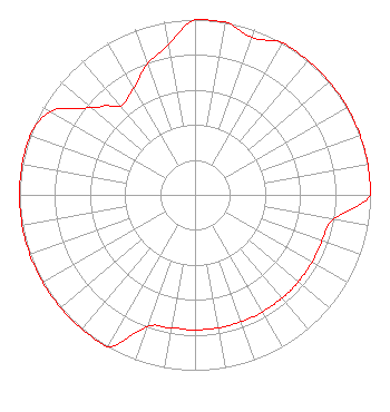 | ||||||||||||||||||
| Azimuth | Ratio | Azimuth | Ratio | Azimuth | Ratio | Azimuth | Ratio | ||||||||||||
| 0 | 1.000 | 10 | 1.000 | 20 | 0.953 | 30 | 1.000 | ||||||||||||
| 40 | 1.000 | 45 | 1.000 | 50 | 1.000 | 60 | 1.000 | ||||||||||||
| 70 | 1.000 | 80 | 1.000 | 90 | 1.000 | 100 | 0.800 | ||||||||||||
| 110 | 0.770 | 120 | 0.770 | 130 | 0.770 | 135 | 0.770 | ||||||||||||
| 140 | 0.770 | 150 | 0.770 | 160 | 0.770 | 170 | 0.770 | ||||||||||||
| 180 | 0.770 | 190 | 0.770 | 200 | 0.800 | 210 | 1.000 | ||||||||||||
| 220 | 1.000 | 225 | 1.000 | 230 | 1.000 | 240 | 1.000 | ||||||||||||
| 250 | 1.000 | 260 | 1.000 | 270 | 1.000 | 275 | 1.000 | ||||||||||||
| 280 | 1.000 | 290 | 1.000 | 300 | 0.950 | 310 | 0.775 | ||||||||||||
| 315 | 0.720 | 320 | 0.660 | 330 | 0.700 | 340 | 0.793 | ||||||||||||
| 350 | 0.871 | ||||||||||||||||||
Structure Registration Number 1051946 Structure Type: LTOWER Registered To: Global Tower, LLC. through American Towers, LLC Structure Address: 4051 St. Catherines Road (370988) Dubuque County, IA County Name: Dubuque County ASR Issued: 10/14/2016 Date Built: 06/23/2006 Site Elevation: 341.4 m (1120 ft.) Structure Height: 114.3 m (375 ft.) Height Overall: 115.2 m (378 ft.) Overall Height AMSL: 456.6 m (1498 ft.) FAA Determination: 05/23/2016 FAA Study #: 2016-ACE-2275-OE FAA Circular #: 70/7460-1L Paint & Light FAA Chapters: 4, 8, 12 PRIOR STUDY 2006-ACE-245-OE 42-24-16.0 N 90-34-12.0 W (NAD 83) 42-24-16.0 N 90-34-11.5 W (Converted to NAD 27) |
Po Drawer 2440 Tupelo, MS 38803 Phone: 662-844-8888 Not-for-Profit | Date: 04/24/2006 Application Certifier AMERICAN FAMILY ASSOCIATION P.o. Drawer 2440 Tupelo, MS 38801 Applicant JESSICA HUCKABY P.o. Drawer 2440 Tupelo, MS 38803 TECHNICAL CONSULTANT JESSICA HUCKABY American Family Association | |||||||||||||||||