
FCCInfo.com
A Service of Cavell, Mertz & Associates, Inc.
(855) FCC-INFO
|
|
K213EH from 10/04/1999 |
|
|
||||||||||||||||
|
|
K213EH Channel: 213D 90.5 MHz Chico, California Service: FX - A translator or application for a translator. Facility ID: 92826 Fac. Service: FX Programming Delivery Method: Unspecified Status: License Application Accepted: 02/19/2015 Application Granted: 03/13/2015 File Number: BLFT-20150219ABZ License Expires: 00/00/0000 Prefix Type: This is a license for a translator Application Type: License To Cover FCC Website Links: LMS Facility Details This Application CDBS Application Other K213EH Applications Other K213EH Applications in CDBS Including Superseded Applications Mailing Address Correspondence for K213EH Correspondence related to application BLFT-20150219ABZ Service Contour - Open Street Map or USGS Map (60 dBu) Service Contour - KML / Google Earth (60 dBu) Class: D, A Noncommercial educational operating with no more than 10W Site Location: 39-43-36.6 N 121-40-48.9 W (NAD 83) Site Location: 39-43-37.0 N 121-40-45.0 W (Converted to NAD 27) Effective Radiated Power: 0 kW Horiz. ; 0.01 kW Vert. Transmitter Output Power: 0.009 kW Antenna Center HAAT: 0 m Antenna Center AMSL: 0 m Horiz.; 392 m Vert. Antenna Center HAG: 0 m Horiz.; 64 m Vert. Site Elevation: 328 m. (1076 ft.) Height Overall*: 79 m (259 ft.) (* As Filed In This Application, may differ from ASR Data, Below.) Directional Antenna Antenna Make/Model: None Antenna ID: 16130 Polarization:
| ||||||||||||||||||
| Antenna Data for Antenna Id: 16130 K213EH FX File: BLFT-20150219ABZ None - Service: FX Pattern and Field Values Include a 285° Clockwise Rotation | 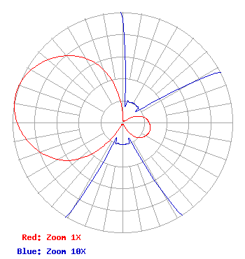 | ||||||||||||||||||
| Azimuth | Ratio | Azimuth | Ratio | Azimuth | Ratio | Azimuth | Ratio | ||||||||||||
| 5 | 0.030 | 15 | 0.020 | 25 | 0.020 | 35 | 0.020 | ||||||||||||
| 45 | 0.020 | 55 | 0.025 | 65 | 0.125 | 75 | 0.195 | ||||||||||||
| 85 | 0.230 | 95 | 0.250 | 105 | 0.260 | 115 | 0.250 | ||||||||||||
| 125 | 0.230 | 135 | 0.195 | 145 | 0.125 | 155 | 0.025 | ||||||||||||
| 165 | 0.020 | 175 | 0.020 | 185 | 0.020 | 195 | 0.020 | ||||||||||||
| 205 | 0.030 | 215 | 0.185 | 225 | 0.410 | 235 | 0.600 | ||||||||||||
| 245 | 0.735 | 255 | 0.840 | 265 | 0.923 | 275 | 0.980 | ||||||||||||
| 285 | 1.000 | 295 | 0.980 | 305 | 0.923 | 315 | 0.840 | ||||||||||||
| 325 | 0.735 | 335 | 0.600 | 345 | 0.410 | 355 | 0.185 | ||||||||||||
Structure Registration Number 1060388 Structure Type: TOWER Registered To: BUTTE BROADCASTING COMPANY INC DBA = KKXX AM Structure Address: 3.8 Mi W On Skyway Paradise, CA County Name: Butte County ASR Issued: 12/14/2010 Date Built: 01/01/1960 Site Elevation: 327.6 m (1075 ft.) Structure Height: 78.3 m (257 ft.) Height Overall: 79.2 m (260 ft.) Overall Height AMSL: 406.8 m (1335 ft.) FAA Determination: 07/29/1988 FAA Study #: 88-AWP-689-OE FAA Circular #: 70/7460-1G Paint & Light FAA Chapters: 3, 4, 5, 9 39-43-37.0 N 121-40-49.0 W (NAD 83) 39-43-37.4 N 121-40-45.1 W (Converted to NAD 27) |
4002 N. 3300 E. Twin Falls, ID 83301 Phone: 208-734-6633 Not-for-Profit | Date: 02/19/2015 Application Certifier CALVARY CHAPEL OF TWIN FALLS, INC. Po Box 391 Twin Falls, ID 83303 Applicant LOIS MILLS Po Box 391 Twin Falls, ID 83303 APPLICATION TECHNICIAN LOIS MILLS Lois Mills Po Box 391 Twin Falls, ID 83303 | |||||||||||||||||