
FCCInfo.com
A Service of Cavell, Mertz & Associates, Inc.
(855) FCC-INFO
|
|
|
|  |
|
|||||||||||||||
|
|
WYRR Channel: 205A 88.9 MHz Lakewood, New York Service: FM - A full-service FM station or application. Facility ID: 175899 Fac. Service: FM Status: License Application Accepted: 02/18/2010 Application Granted: 03/02/2010 File Number: BLED-20100218AAJ License Expires: 00/00/0000 Prefix Type: This is a license for a noncommercial educational FM station Application Type: License To Cover FCC Website Links: LMS Facility Details This Application CDBS Application Other WYRR Applications Other WYRR Applications in CDBS Including Superseded Applications Mailing Address Correspondence for WYRR Correspondence related to application BLED-20100218AAJ Service Contour - Open Street Map or USGS Map (60 dBu) Service Contour - KML / Google Earth (60 dBu) Public Inspection Files Facility Type: NON-COMMERCIAL EDUC. FM Class: A, A Zone I; I-A; or II station; with 0.1kW-6kW ERP and a class contour distance <=28km Site Location: 42-10-33.2 N 79-19-01.2 W (NAD 83) Site Location: 42-10-33.0 N 79-19-02.0 W (Converted to NAD 27) Effective Radiated Power: 0.42 kW Horiz. ; 0.336 kW Vert. Transmitter Output Power: 0.162 kW Antenna Center HAAT: 102 m (335 ft.) Antenna Center AMSL: 563 m (1847 ft.) Antenna Center HAG: 27.2 m (89 ft.) Calculated Site Elevation: 535.8 m. (1758 ft.) Height Overall*: 30.5 m (100 ft.) (* As Filed In This Application, may differ from ASR Data, Below.) Directional Antenna Antenna Make/Model: Propagation System Inc PSIFMY-1-DA, One Section Antenna ID: 83506 Polarization: | ||||||||||||||||||
| Antenna Data for Antenna Id: 83506 WYRR FM File: BLED-20100218AAJ Propagation System Inc - PSIFMY-1-DA, One Section Service: FM | 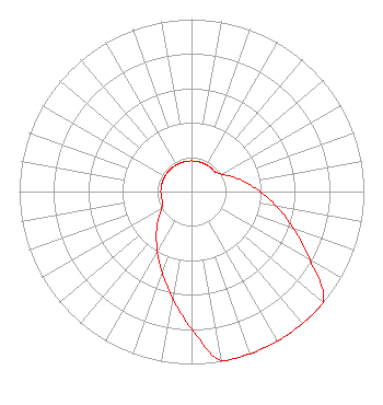 | ||||||||||||||||||
| Azimuth | Ratio | Azimuth | Ratio | Azimuth | Ratio | Azimuth | Ratio | ||||||||||||
| 0 | 0.178 | 10 | 0.178 | 20 | 0.178 | 30 | 0.178 | ||||||||||||
| 40 | 0.178 | 50 | 0.178 | 60 | 0.201 | 70 | 0.252 | ||||||||||||
| 80 | 0.317 | 90 | 0.399 | 100 | 0.502 | 110 | 0.632 | ||||||||||||
| 120 | 0.795 | 130 | 1.000 | 140 | 1.000 | 150 | 1.000 | ||||||||||||
| 160 | 1.000 | 170 | 0.999 | 180 | 0.794 | 190 | 0.631 | ||||||||||||
| 200 | 0.501 | 210 | 0.398 | 220 | 0.317 | 230 | 0.252 | ||||||||||||
| 240 | 0.201 | 250 | 0.178 | 260 | 0.178 | 270 | 0.178 | ||||||||||||
| 280 | 0.178 | 290 | 0.178 | 300 | 0.178 | 310 | 0.178 | ||||||||||||
| 320 | 0.178 | 330 | 0.178 | 340 | 0.178 | 350 | 0.178 | ||||||||||||
Structure Registration Number 1005709 [ASR Heights Differ from WYRR Application] Structure Type: GTOWER Registered To: VB-S1 Assets, LLC Structure Address: 4330 Beck Road / Us-ny-5027 Jamestown, NY County Name: Chautauqua County ASR Issued: 01/10/2020 Date Built: 01/01/1993 Site Elevation: 532.2 m (1746 ft.) Structure Height: 43.3 m (142 ft.) Height Overall: 45.4 m (149 ft.) Overall Height AMSL: 577.6 m (1895 ft.) FAA Determination: 09/13/2019 FAA Study #: 2019-AEA-7172-OE Paint & Light FAA Chapters: NONE PRIOR STUDY 1992-AEA-736-OE 42-10-34.5 N 79-19-00.7 W (NAD 83) 42-10-34.3 N 79-19-01.5 W (Converted to NAD 27) |
8919 World Ministry Avenue Baton Rouge, LA 70810 Phone: 225-768-3102 | Date: 02/18/2010 Application Certifier FAMILY WORSHIP CENTER CHURCH, INC. P.o. Box 262550 Baton Rouge, LA 70810 Applicant JEFFERSON G. BROCK Graham Brock, Inc. P.o. Box 24466 St. Simons Island, GA 31522-7466 TECHNICAL CONSULTANT JOHN C. TRENT, ESQUIRE Putbrese Hunsaker & Trent, P.c. | |||||||||||||||||