
FCCInfo.com
A Service of Cavell, Mertz & Associates, Inc.
(855) FCC-INFO
|
|
DKTDO-LP from 02/08/2017 DKTDO-LP from 02/24/2004 DKTDO-LP from 03/18/1993 |
|
|
||||||||||||||||
|
|
Status: License Application Accepted: 12/21/2018 License Expires: 08/01/2022 File Number: -0000064333 FCC Website Links: LMS Facility Details This Application Other DKTDO-LP Applications Including Superseded Applications Mailing Address Correspondence for DKTDO-LP Correspondence related to application -0000064333 Service Contour - Open Street Map or USGS Map (74 dBu) Service Contour - KML / Google Earth (74 dBu) Rabbit Ears Info Search for DKTDO-LP Site Location: 31-47-15.0 N 106-28-49.0 W (NAD 83) Site Location: 31-47-14.6 N 106-28-47.0 W (Converted to NAD 27) ERP: 150 kW R/C AGL: 25.9 m (85 ft.) R/C AMSL: 1447.2 m (4748 ft.) Site Elevation: 1421.3 m. (4663 ft.) Height Overall*: 90.5 m (297 ft.) (* As Filed In This Application, may differ from ASR Data, Below.) Directional Antenna - Antenna Make/Model: Andrew ALP12M8-HSWR-48 Antenna ID: 60128 | ||||||||||||||||||
| Antenna Data for Antenna Id: 60128 DKTDO-LP TX File: -0000064333 Andrew - ALP12M8-HSWR-48 Service: TX Standard Pattern: Y | 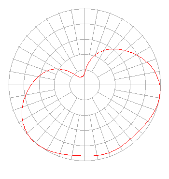 | ||||||||||||||||||
| Azimuth | Ratio | Azimuth | Ratio | Azimuth | Ratio | Azimuth | Ratio | ||||||||||||
| 0 | 0.148 | 10 | 0.272 | 20 | 0.412 | 30 | 0.521 | ||||||||||||
| 40 | 0.612 | 50 | 0.697 | 60 | 0.785 | 70 | 0.870 | ||||||||||||
| 80 | 0.942 | 90 | 0.988 | 100 | 1.000 | 110 | 0.986 | ||||||||||||
| 120 | 0.961 | 130 | 0.940 | 140 | 0.934 | 150 | 0.944 | ||||||||||||
| 160 | 0.950 | 170 | 0.944 | 180 | 0.934 | 190 | 0.940 | ||||||||||||
| 200 | 0.961 | 210 | 0.986 | 220 | 1.000 | 230 | 0.988 | ||||||||||||
| 240 | 0.942 | 250 | 0.870 | 260 | 0.785 | 270 | 0.697 | ||||||||||||
| 280 | 0.612 | 290 | 0.521 | 300 | 0.412 | 310 | 0.272 | ||||||||||||
| 320 | 0.148 | 330 | 0.112 | 340 | 0.111 | 350 | 0.112 | ||||||||||||
Structure Registration Number 1047783 Structure Type: TOWER Registered To: 88 Investments, Inc. Structure Address: South Slope Commanche Peak El Paso, TX County Name: El Paso County ASR Issued: 10/04/2006 Date Built: 01/01/1960 Site Elevation: 1421.3 m (4663 ft.) Structure Height: 67.7 m (222 ft.) Height Overall: 90.5 m (297 ft.) Overall Height AMSL: 1511.8 m (4960 ft.) FAA Determination: 03/17/1982 FAA Study #: 82-ASW-512-OE Paint & Light FAA Chapters: 1, 3, 11, 21 RED LIGHTS/PAINT 31-47-15.0 N 106-28-49.0 W (NAD 83) 31-47-14.6 N 106-28-47.0 W (Converted to NAD 27) |
300 New Jersey Avenue, Nw Suite 700 Washington, DC 20001 Phone: 202-524-6401 Limited Liability Company | Title: Assistant Secretary Date: 12/21/2018 Application Certifier NBC TELEMUNDO LICENSE LLC Nbc Telemundo License Llc 300 New Jersey Avenue, Nw Suite 700 Washington, DC 20001 Applicant H. Douglas Lung Nbcuniversal, Llc Honomu, HI 96728 Corporate Engineering Manager Margaret L. Tobey Nbc Telemundo License Llc 300 New Jersey Avenue, Nw Suite 700 Washington, DC 20001 Assistant Secretary | |||||||||||||||||