
FCCInfo.com
A Service of Cavell, Mertz & Associates, Inc.
(855) FCC-INFO
|
|
WFBN-LD from 03/16/2007 |
|
|
||||||||||||||||
|
|
Status: License Application Accepted: 10/31/2019 License Expires: 12/01/2021 File Number: -0000087738 FCC Website Links: LMS Facility Details This Application Other WFBN-LD Applications Including Superseded Applications Mailing Address Correspondence for WFBN-LD Correspondence related to application -0000087738 Service Contour - Open Street Map or USGS Map (51 dBu) Service Contour - KML / Google Earth (51 dBu) Rabbit Ears Info Search for WFBN-LD Site Location: 42-17-48.0 N 89-10-15.0 W (NAD 83) Site Location: 42-17-47.9 N 89-10-14.6 W (Converted to NAD 27) ERP: 15 kW Polarization: Elliptically polarized Electrical Beam Tilt: 1.0 degree R/C AGL: 191 m (627 ft.) R/C AMSL: 440.9 m (1447 ft.) Emission Mask: Stringent Site Elevation: 249.9 m. (820 ft.) Height Overall*: 222.2 m (729 ft.) (* As Filed In This Application, may differ from ASR Data, Below.) Directional Antenna - Antenna Make/Model: ATC ATC-BCE48CF-V2-23 Antenna ID: 1005883 Polarization: Elliptically polarized | ||||||||||||||||||
| Antenna Data for Antenna Id: 1005883 WFBN-LD LD File: -0000087738 ATC - ATC-BCE48CF-V2-23 Service: LD Standard Pattern: N Pattern and Field Values Include a 90° Clockwise Rotation | 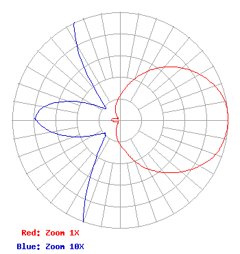 | ||||||||||||||||||
| Azimuth | Ratio | Azimuth | Ratio | Azimuth | Ratio | Azimuth | Ratio | ||||||||||||
| 0 | 0.224 | 10 | 0.304 | 20 | 0.409 | 30 | 0.525 | ||||||||||||
| 40 | 0.640 | 50 | 0.750 | 60 | 0.849 | 70 | 0.932 | ||||||||||||
| 80 | 0.987 | 90 | 1.000 | 100 | 0.983 | 110 | 0.939 | ||||||||||||
| 120 | 0.850 | 130 | 0.745 | 140 | 0.634 | 150 | 0.521 | ||||||||||||
| 160 | 0.405 | 170 | 0.296 | 180 | 0.223 | 190 | 0.165 | ||||||||||||
| 200 | 0.101 | 210 | 0.049 | 220 | 0.023 | 227 | 0.019 | ||||||||||||
| 230 | 0.019 | 240 | 0.028 | 250 | 0.045 | 260 | 0.064 | ||||||||||||
| 270 | 0.077 | 272 | 0.078 | 280 | 0.071 | 290 | 0.051 | ||||||||||||
| 300 | 0.028 | 310 | 0.017 | 320 | 0.035 | 330 | 0.080 | ||||||||||||
| 340 | 0.125 | 350 | 0.168 | ||||||||||||||||
Structure Registration Number 1209945 [ASR Heights Differ from WFBN-LD Application] Structure Type: GTOWER Registered To: Gray Media Group, Inc. Structure Address: 2523 North Meridian Road Rockford, IL County Name: Winnebago County ASR Issued: 08/25/2022 Date Built: 03/01/2000 Site Elevation: 249.3 m (818 ft.) Structure Height: 205.9 m (676 ft.) Height Overall: 214.3 m (703 ft.) Overall Height AMSL: 463.6 m (1521 ft.) FAA Determination: 04/26/2021 FAA Study #: 2021-AGL-7283-OE Paint & Light FAA Chapters: 1, 3, 6, 15, 21 Continue As Is OM&L = PAINT/RED LIGHTS 42-17-48.3 N 89-10-15.0 W (NAD 83) 42-17-48.2 N 89-10-14.6 W (Converted to NAD 27) |
26 North Halsted Street Chicago, IL 60661 Phone: 312-705-2600 Corporation | Title: President/secretary/treasurer Date: 10/31/2019 Application Certifier WEIGEL BROADCASTING CO. Weigel Broadcasting Co. 26 North Halsted Street Chicago, IL 60661 Applicant Matthew S. DelNero, Esq Covington & Burling Llp One Citycenter, 850 Tenth Street, N.w. Washington, DC 20001 Legal Counsel Louis R duTreil, Jr Dutreil Lundin & Rackley Inc 3135 Southgate Circle Sarasota, FL 34239 Technical Consultant | |||||||||||||||||