
FCCInfo.com
A Service of Cavell, Mertz & Associates, Inc.
(855) FCC-INFO
|
|
WGCT-CD from 05/04/2004 WGCT-CD from 06/12/1998 WGCT-CD from 11/10/1983 |
|
|
||||||||||||||||
|
|
Repacking Information: No changes Status: License Application Accepted: 09/06/2022 License Expires: 10/01/2029 File Number: -0000199291 FCC Website Links: LMS Facility Details This Application Other WGCT-CD Applications Including Superseded Applications Mailing Address Correspondence for WGCT-CD Correspondence related to application -0000199291 Service Contour - Open Street Map or USGS Map (48 dBu) Service Contour - KML / Google Earth (48 dBu) Public Inspection Files Rabbit Ears Info Search for WGCT-CD Site Location: 39-58-16.0 N 83-01-40.0 W (NAD 83) Site Location: 39-58-15.8 N 83-01-40.3 W (Converted to NAD 27) ERP: 3 kW Polarization: Elliptically polarized Electrical Beam Tilt: 1.0 degree R/C AGL: 123.5 m (405 ft.) R/C AMSL: 343 m (1125 ft.) Emission Mask: Stringent Site Elevation: 219.5 m. (720 ft.) Height Overall*: 313.5 m (1029 ft.) (* As Filed In This Application, may differ from ASR Data, Below.) Directional Antenna - Antenna Make/Model: ALIVE ATC-BCE4C1-V1-8 Antenna ID: 1010030 Polarization: Elliptically polarized | ||||||||||||||||||
| Antenna Data for Antenna Id: 1010030 WGCT-CD DC File: -0000199291 ALIVE - ATC-BCE4C1-V1-8 Service: DC Standard Pattern: N Pattern and Field Values Include a 123° Clockwise Rotation | 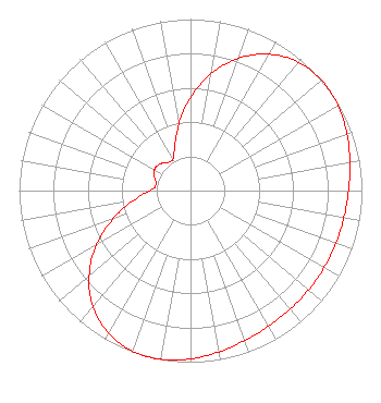 | ||||||||||||||||||
| Azimuth | Ratio | Azimuth | Ratio | Azimuth | Ratio | Azimuth | Ratio | ||||||||||||
| 3 | 0.588 | 13 | 0.733 | 23 | 0.854 | 33 | 0.940 | ||||||||||||
| 43 | 0.987 | 53 | 1.000 | 63 | 0.988 | 73 | 0.963 | ||||||||||||
| 83 | 0.936 | 93 | 0.917 | 103 | 0.906 | 113 | 0.900 | ||||||||||||
| 123 | 0.899 | 133 | 0.900 | 143 | 0.905 | 153 | 0.917 | ||||||||||||
| 163 | 0.936 | 173 | 0.963 | 183 | 0.988 | 193 | 1.000 | ||||||||||||
| 203 | 0.987 | 213 | 0.940 | 223 | 0.854 | 233 | 0.733 | ||||||||||||
| 243 | 0.588 | 253 | 0.437 | 263 | 0.302 | 273 | 0.218 | ||||||||||||
| 283 | 0.207 | 293 | 0.232 | 303 | 0.245 | 313 | 0.232 | ||||||||||||
| 323 | 0.207 | 333 | 0.218 | 343 | 0.302 | 353 | 0.437 | ||||||||||||
Structure Registration Number 1040501 Structure Type: Registered To: WBNS-TV, Inc. Structure Address: 766 Twin Rivers Drive Columbus, OH County Name: Franklin County ASR Issued: 08/20/2019 Date Built: 06/30/1982 Site Elevation: 219.5 m (720 ft.) Structure Height: 277.4 m (910 ft.) Height Overall: 313.5 m (1029 ft.) Overall Height AMSL: 533 m (1749 ft.) FAA Determination: 04/26/1997 FAA Study #: 76-AGL-1614-OE FAA Circular #: 70/7460-1F Paint & Light FAA Chapters: 4, 6, 7, 9 39-58-16.0 N 83-01-40.0 W (NAD 83) 39-58-15.8 N 83-01-40.3 W (Converted to NAD 27) |
1282 N. Main Street Marion, OH 43302 Phone: 740-383-1794 Not-for-Profit | Title: President Date: 09/06/2022 Application Certifier CENTRAL OHIO ASSOCIATION OF CHRISTIAN BROADCASTERS, INC. Central Ohio Association Of Christian Broadcasters, Inc. 1282 N. Main Street Marion, OH 43302 Applicant Jonathan David Aiken The Central Ohio Asssociation Of Christian Broadcasters 1282 North Main Street Marion, OH 43302 President Greg Best Greg Best Consulting, Inc. 16100 Outlook Avenue Stilwell, KS 66085 Consulting Engineer | |||||||||||||||||