
FCCInfo.com
A Service of Cavell, Mertz & Associates, Inc.
(855) FCC-INFO
|
|
|
Virtual Channel 53 |  |
|
||||||||||||||||||
|
|
Repacking Information: No changes Status: License Application Accepted: 05/16/2023 License Expires: 04/01/2031 File Number: -0000207355 FCC Website Links: LMS Facility Details This Application Other WEDN Applications Including Superseded Applications Mailing Address Correspondence for WEDN Correspondence related to application -0000207355 Service Contour - Open Street Map or USGS Map (36 dBu) Service Contour - KML / Google Earth (36 dBu) Public Inspection Files History Cards for WEDN Rabbit Ears Info Search for WEDN Site Location: 41-31-14.0 N 72-10-01.0 W (NAD 83) Site Location: 41-31-13.6 N 72-10-02.7 W (Converted to NAD 27) ERP: 4.2 kW Polarization: Horizontally polarized HAAT: 192 m (630 ft.) R/C AGL: 129 m (423 ft.) R/C AMSL: 284.4 m (933 ft.) Site Elevation: 155.4 m. (510 ft.) Height Overall*: 145.3 m (477 ft.) (* As Filed In This Application, may differ from ASR Data, Below.) Directional Antenna - Antenna Make/Model: DIELECTRIC TLS-V4 Antenna ID: 91371 Polarization: Horizontally polarized | |||||||||||||||||||||
| Antenna Data for Antenna Id: 91371 WEDN DT File: -0000207355 DIELECTRIC - TLS-V4 Service: DT Standard Pattern: Y | 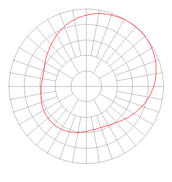 | |||||||||||||||||||||
| Azimuth | Ratio | Azimuth | Ratio | Azimuth | Ratio | Azimuth | Ratio | |||||||||||||||
| 0 | 0.914 | 10 | 0.951 | 20 | 0.975 | 30 | 0.993 | |||||||||||||||
| 40 | 1.000 | 50 | 0.996 | 60 | 0.981 | 70 | 0.955 | |||||||||||||||
| 80 | 0.920 | 90 | 0.876 | 100 | 0.826 | 110 | 0.771 | |||||||||||||||
| 120 | 0.714 | 130 | 0.661 | 140 | 0.615 | 150 | 0.583 | |||||||||||||||
| 160 | 0.569 | 170 | 0.571 | 180 | 0.586 | 190 | 0.607 | |||||||||||||||
| 200 | 0.627 | 210 | 0.640 | 220 | 0.645 | 230 | 0.641 | |||||||||||||||
| 240 | 0.631 | 250 | 0.613 | 260 | 0.592 | 270 | 0.579 | |||||||||||||||
| 280 | 0.570 | 290 | 0.579 | 300 | 0.610 | 310 | 0.650 | |||||||||||||||
| 320 | 0.699 | 330 | 0.759 | 340 | 0.817 | 350 | 0.869 | |||||||||||||||
Structure Registration Number 1035286 Structure Type: TOWER Registered To: CONNECTICUT PUBLIC BROADCASTING, INC. Structure Address: Bishop Road, 3.2 Miles South Of Fitchville, Ct Bozrah, CT County Name: New London County ASR Issued: 01/15/1998 Date Built: 01/01/1967 Site Elevation: 155.4 m (510 ft.) Structure Height: 137.1 m (450 ft.) Height Overall: 145.3 m (477 ft.) Overall Height AMSL: 300.7 m (987 ft.) FAA Determination: 10/16/1997 FAA Study #: 97-ANE-0511-OE Paint & Light FAA Chapters: 1, 3, 4, 13, 21 Removed expiration date from determination. Scenario 1./jjs/case#635066 41-31-14.0 N 72-10-01.0 W (NAD 83) 41-31-13.6 N 72-10-02.7 W (Converted to NAD 27) |
1049 Asylum Avenue Hartford, CT 06105 Phone: 860-275-7314 Not-for-Profit | Title: Cfo Date: 05/16/2023 Application Certifier CONNECTICUT PUBLIC BROADCASTING, INC. Connecticut Public Broadcasting, Inc. 1049 Asylum Avenue Hartford, CT 06105 Applicant Louis R duTreil, Jr Dutreil Lundin & Rackley Inc 5212 Station Way Sarasota, FL 34233 Sally A. Buckman Lerman Senter Pllc 2001 L Street, Nw, Suite 400 Washington, DC 20036 Attorney | ||||||||||||||||||||
| ||||||||||||||||||||||
