
FCCInfo.com
A Service of Cavell, Mertz & Associates, Inc.
(855) FCC-INFO
|
|
KFAW-LD from 04/04/2013 KFAW-LD from 03/28/2013 KFAW-LD from 01/30/2012 |
|
|
||||||||||||||||
|
|
Status: License Application Accepted: 07/17/2023 License Expires: 08/01/2030 File Number: -0000218023 FCC Website Links: LMS Facility Details This Application Other KFAW-LD Applications Including Superseded Applications Mailing Address Correspondence for KFAW-LD Correspondence related to application -0000218023 Service Contour - Open Street Map or USGS Map (51 dBu) Service Contour - KML / Google Earth (51 dBu) Rabbit Ears Info Search for KFAW-LD Site Location: 32-17-45.0 N 102-10-00.0 W (NAD 83) Site Location: 32-17-44.6 N 102-09-58.5 W (Converted to NAD 27) ERP: 15 kW Polarization: Horizontally polarized R/C AGL: 89 m (292 ft.) R/C AMSL: 975.4 m (3200 ft.) Emission Mask: Full Service Site Elevation: 886.4 m. (2908 ft.) Height Overall*: 91.4 m (300 ft.) (* As Filed In This Application, may differ from ASR Data, Below.) Directional Antenna - Antenna Make/Model: SIRA UTV01 x2 BC Antenna ID: 1010889 Polarization: Horizontally polarized | ||||||||||||||||||
| Antenna Data for Antenna Id: 1010889 KFAW-LD LD File: -0000218023 SIRA - UTV01 x2 BC Service: LD Standard Pattern: N | 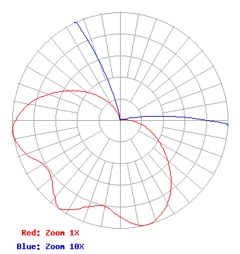 | ||||||||||||||||||
| Azimuth | Ratio | Azimuth | Ratio | Azimuth | Ratio | Azimuth | Ratio | ||||||||||||
| 0 | 0.001 | 10 | 0.001 | 20 | 0.001 | 30 | 0.001 | ||||||||||||
| 40 | 0.001 | 50 | 0.001 | 60 | 0.001 | 70 | 0.001 | ||||||||||||
| 80 | 0.014 | 90 | 0.081 | 100 | 0.189 | 110 | 0.303 | ||||||||||||
| 120 | 0.429 | 130 | 0.575 | 140 | 0.735 | 150 | 0.884 | ||||||||||||
| 160 | 0.975 | 165 | 1.000 | 170 | 0.985 | 180 | 0.894 | ||||||||||||
| 190 | 0.809 | 200 | 0.852 | 210 | 0.957 | 215 | 0.988 | ||||||||||||
| 220 | 0.936 | 230 | 0.831 | 240 | 0.819 | 250 | 0.921 | ||||||||||||
| 260 | 0.990 | 265 | 1.000 | 270 | 0.963 | 280 | 0.857 | ||||||||||||
| 290 | 0.702 | 300 | 0.545 | 310 | 0.402 | 320 | 0.281 | ||||||||||||
| 330 | 0.166 | 340 | 0.062 | 350 | 0.009 | ||||||||||||||
Structure Registration Number 1048229 Structure Type: TOWER Registered To: South Plains Communications Structure Address: 1/4 Mi S Of Jct Hwy 176 & 349 Midland, TX County Name: Martin County ASR Issued: 11/18/2009 Date Built: 07/01/1987 Site Elevation: 886.4 m (2908 ft.) Structure Height: 91.4 m (300 ft.) Height Overall: 91.4 m (300 ft.) Overall Height AMSL: 977.8 m (3208 ft.) FAA Determination: 07/07/1987 FAA Study #: 87-ASW-0919-OE Paint & Light FAA Chapters: 1, 3, 11, 21 32-17-45.0 N 102-10-00.0 W (NAD 83) 32-17-44.6 N 102-09-58.5 W (Converted to NAD 27) |
3101 North Midland Drive Suite 700 Midland, TX 79710 Phone: 432-967-5623 Corporation | Title: Manager Date: 07/17/2023 Application Certifier Anointing Winds, Inc. 3101 North Midland Drive Suite 700 Midland, TX 79710 Applicant Jim McPhetridge Jim Mcphetridge 104 Woodmont Montgomery, TX 77356 Broadcast Engineer David G. O'Neil, Esq Rini O'neil, Pc 2101 L Street, Nw Suite 700 Washington, DC 20037 | |||||||||||||||||